
Geographical Features of Algeria
Algeria, located in North Africa, features a diverse and striking landscape shaped by its vast size and varied climate. The country’s geography includes expansive deserts, towering mountain ranges, fertile plains, and a rugged coastline along the Mediterranean Sea. These geographical features play a significant role in shaping Algeria’s climate, biodiversity, and human activities throughout its regions.
Desert Landscapes and the Sahara
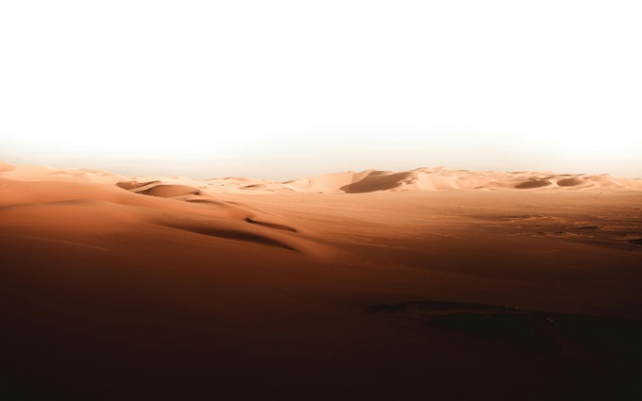
Algeria is a country renowned for its diverse geographical features, which include vast deserts, rugged mountains, and coastal plains. Its landscape is largely shaped by the expansive Sahara Desert, which covers a significant portion of the country, giving Algeria its characteristic desert landscapes. These areas are marked by endless sand dunes, rocky plateaus, and sparse vegetation, creating a striking and vast desert environment. The Sahara’s presence influences much of Algeria’s climate, making it arid and harsh, especially in the southern regions.
- Desert Landscapes: Characterized by towering sand dunes, oases, and rocky outcrops. These regions are mostly uninhabited and are home to unique desert flora and fauna.
- Sahara Desert: The largest hot desert in the world, covering approximately 80% of Algeria. It features iconic features such as erg (sand seas), hamadas (stone plateaus), and Erg Chech dunes.
- Mountain Ranges: The Tell Atlas along the northern coast and the Saharan Atlas in the north-central region provide elevation changes, with the Atlas Mountains reaching heights of over 2,700 meters in some areas.
- Coastal Plains: Fertile regions along the Mediterranean Sea, supporting agriculture and urban development.
Mountain Ranges: The Atlas and Tell Mountains
Algeria, a country situated in North Africa, boasts diverse geographical features, including prominent mountain ranges such as the Atlas and Tell Mountains. The Atlas Mountains stretch across the northern part of the country, forming a rugged barrier that separates the coastal plains from the Sahara Desert. These mountains are characterized by deep valleys, high peaks, and rich green landscapes, supporting various flora and fauna. The Tell Mountains, part of the larger system of the Atlas, run parallel to the Mediterranean coast and are known for their fertile valleys and agricultural significance. Together, these mountain ranges contribute to Algeria’s diverse climate and topography, playing a vital role in the country’s natural ecosystem and human settlement patterns.
Coastal Plains and Beaches
Algeria, a country located in North Africa, boasts a diverse array of geographical features, including extensive coastal plains and beautiful beaches along the Mediterranean Sea. The coastal plains extend along the northern edge of the country, offering flat and fertile land that supports agriculture and urban development. These plains are characterized by their lush vegetation and suitable climate, which benefits both local communities and tourism. The beaches in Algeria are renowned for their pristine sands and clear waters, attracting visitors from around the world. Notable beaches like those near Algiers, Oran, and Annaba provide ideal spots for swimming, sunbathing, and water sports, making the coastal region an important part of Algeria’s natural landscape and economic activity. Overall, the coastal plains and beaches significantly contribute to the country’s rich geographical diversity and appeal.
Major Rivers and Water Bodies
Algeria, a country in North Africa, is characterized by diverse geographical features that shape its landscape and climate. Its terrain includes vast deserts, mountainous regions, and fertile plains, making it a unique and varied region.
Major rivers and water bodies in Algeria include several significant waterways that contribute to the country’s hydrography and ecosystem. These water bodies play an essential role in agriculture, transportation, and regional water supply.
- Rivers:
- Rhumel River: Flows through the eastern part of the country and passes through the city of Constantine.
- Mila River: A prominent river in northeastern Algeria, vital for agriculture in the region.
- Seybouse River: Located in the northeastern part, it is an important waterway for local communities.
- Chelif River: The longest river in Algeria, running through the Tell Atlas and supporting regional agriculture.
- Medjerda River: Originates in Tunisia but forms part of the border with Algeria and is significant in surrounding areas.
- Water Bodies:
- Mediterranean Sea: Borders northern Algeria, providing access to maritime trade and marine biodiversity.
- Chott el Djerid: A large salt lake in the southeastern part of the country, part of the Algerian Sahara region.
- Lake Chad: Though primarily in Chad, it influences the eastern region nearby, important for regional water systems.
Climatic Zones and Weather Patterns
Algeria, a country characterized by diverse landscapes and climates, exhibits a range of climatic zones and weather patterns that influence its environment and way of life. From the arid Sahara Desert in the south to the Mediterranean coastal region in the north, each zone experiences distinct weather conditions. Understanding these climatic variations is essential to appreciating the natural diversity and ecological challenges faced by Algeria.
Arid Desert Climate
The Algeria region features a diverse range of climatic zones, with the arid desert climate being the most prominent, especially in the interior areas such as the Sahara Desert. This climate is characterized by extremely low rainfall, high temperatures during the day, and significant temperature drops at night. Weather patterns in these regions are largely dictated by the influence of the Sahara, resulting in long, hot summers and mild winters with minimal precipitation. In coastal areas, the climate is more temperate with milder temperatures and higher humidity, influenced by the Mediterranean Sea. Overall, the climatic variation across Algeria plays a crucial role in shaping the environment, flora, and fauna of the region, with the arid desert climate dominating the vast central and southern parts of the country.
Mediterranean Climate along the Coast
The Mediterranean climate along the coast of Algeria is characterized by warm, dry summers and mild, wet winters. This climatic zone influences the region’s vegetation, agriculture, and lifestyle, creating a distinct climate pattern compared to other parts of the country.
- Summer temperatures often rise above 30°C (86°F), with extended dry periods that support drought-resistant vegetation.
- Winter months bring rainfall, helping to sustain agriculture and replenish water sources in the coastal areas.
- Humidity levels are moderate, creating a comfortable climate for residents and visitors during most of the year.
- Precipitation primarily occurs between October and April, with the highest rainfall typically seen in the winter months.
This climate zone fosters the growth of Mediterranean flora such as olives, grapes, and citrus fruits, making agriculture a vital part of the region’s economy. The weather patterns also influence cultural and social activities, with many festivals and outdoor events taking advantage of the mild winters and warm summers.
Mountain Climate Variations
Algeria’s diverse geography results in a variety of climatic zones and weather patterns. The coastal regions along the Mediterranean Sea enjoy a Mediterranean climate characterized by mild, wet winters and hot, dry summers. Moving inland, the climate becomes more continental with greater temperature variations and less precipitation. The Saharan desert region experiences an arid climate marked by extreme temperature fluctuations between day and night, with very little rainfall throughout the year. Mountain areas, particularly the Atlas Mountains, display unique climate variations due to their elevation. As altitude increases, temperatures drop significantly, leading to cooler environments and increased precipitation, often in the form of snow at higher altitudes. These variations influence local weather patterns, vegetation, and human activity across the country.
Seasonal Weather Changes
Algeria, a vast country in North Africa, spans multiple climatic zones and experiences diverse weather patterns throughout the year. Its geographical diversity, from the Mediterranean coast to the Sahara Desert, influences its climate and seasonal weather changes.
The coastal region of Algeria, along the Mediterranean Sea, has a Mediterranean climate characterized by mild, wet winters and hot, dry summers. This zone experiences moderate seasonal variations with abundant rainfall during winter months, supporting lush vegetation and agriculture.
Further inland, the areas in the Atlas Mountains showcase a Mediterranean mountain climate, marked by cooler temperatures and higher precipitation, especially in the winter, often resulting in snowfall which supports winter sports and alpine ecosystems.
In contrast, the Sahara Desert in the south exhibits an arid climate with extreme temperature fluctuations, very low rainfall, and intense heat during the day. Winters are milder but can be surprisingly cold at night, and the region experiences drastic seasonal weather changes due to its desert nature.
- Winter (December to February): The northern regions experience cooler temperatures with increased rainfall, particularly along the coast and mountainous areas. The Sahara region remains dry with minimal changes in temperature.
- Summer (June to August): The coastal and mountainous areas face high temperatures and dry conditions. In the Sahara, temperatures often soar above 40°C (104°F), with almost no rainfall.
- Spring and Autumn: These transitional seasons bring moderate temperatures, with spring seeing flowering and greenery in the north, while autumn gradually cools the climate before winter.
Overall, Algeria’s climatic zones and weather patterns are deeply influenced by its topography, with coastal regions enjoying milder weather, mountainous zones experiencing cooler and wetter conditions, and the Sahara hosting extreme desert climates with significant temperature swings throughout the year.
Regions and Administrative Divisions
Algeria is a diverse country characterized by its various regions and administrative divisions, each reflecting unique cultural, geographical, and historical traits. These divisions help organize the nation’s governance, facilitate regional development, and preserve local identities. Understanding Algeria’s regions and administrative structure provides insight into the country’s rich diversity and complex administrative framework.
Algiers and the Central Region
The Central Region of Algeria, including Algiers, serves as a vital administrative and economic hub. Algiers, the capital city, is situated within the Algiers Province, which is part of the broader Central Region. This region is characterized by its urbanization, diverse cultural heritage, and significant political importance. Administrative divisions in Algeria typically consist of provinces known as “wilayas,” with Algiers being one of the most prominent due to its historical and strategic significance. The Central Region plays a crucial role in the country’s governance, commerce, and transportation networks, making it a key area for both administrative functions and regional development.
Eastern Algeria: Annaba and Constantine
Eastern Algeria is a significant region characterized by its diverse landscapes, rich history, and vibrant cultural heritage. Among its most prominent areas are the provinces of Annaba and Constantine, which serve as important centers of economic activity, education, and cultural traditions.
Annaba, located along the Mediterranean coast, is a major port city known for its industrial contributions, including steel production and maritime trade. It boasts a picturesque coastline with beautiful beaches and historical sites, reflecting its ancient roots as the Roman city of Hippo Regius.
Constantine, often called the “City of Bridges,” is renowned for its dramatic mountainous terrain and impressive architecture. It functions as a regional hub for education and administration, featuring numerous universities, cultural institutions, and historical landmarks such as its numerous bridges spanning deep gorges. The city’s history dates back to antiquity, with significant archaeological sites and museums highlighting its rich past.
Both Annaba and Constantine contribute significantly to the economic and cultural landscape of eastern Algeria, embodying the region’s blend of historical significance and modern development. Their unique features make them vital components of Algeria’s overall national identity and regional diversity.
Western Algeria: Oran and Tlemcen
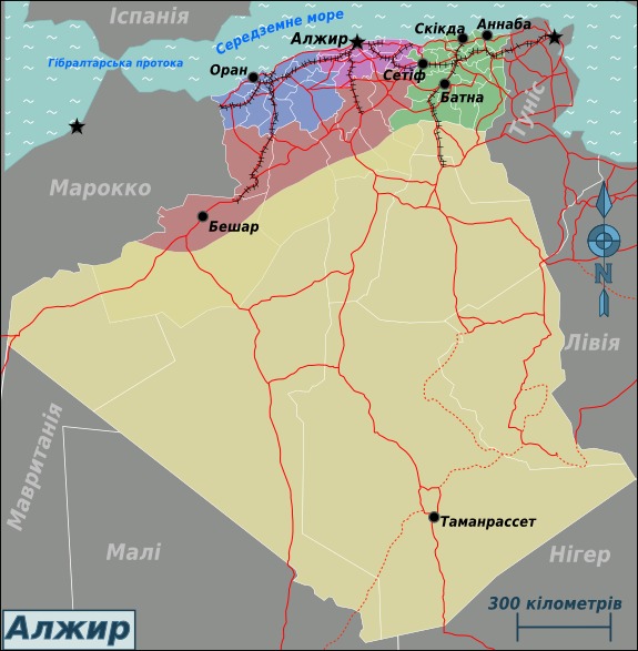
Western Algeria is a historically significant and culturally rich region that encompasses various administrative divisions, with Oran and Tlemcen serving as prominent cities. These areas are known for their diverse landscapes, vibrant traditions, and economic importance within the country.
Oran, the second largest city in Algeria, is a major port and commercial hub situated along the Mediterranean coast. It has a lively cultural scene, notable for its music, festivals, and historical sites such as the Santa Cruz Fortress. The city plays a vital role in Algeria’s economy, particularly in industry, trade, and transportation.
Tlemcen, located inland, is renowned for its historical significance and Islamic heritage. It has a rich history as a center for learning, art, and architecture, with landmarks like the Great Mosque of Tlemcen and the Tlemcen Palace. The region’s landscape features mountains, olive groves, and lush greenery, contributing to its agricultural activities.
Together, Oran and Tlemcen exemplify the diverse cultural and geographic features of Western Algeria, making the region an essential part of the country’s national identity and development.
Southern Sahara Region
The Southern Sahara Region of Algeria is a vast and sparsely populated area characterized by its arid desert landscape, including parts of the Sahara Desert. This region is known for its extreme climate, with high temperatures during the day and cooler nights, and minimal rainfall throughout the year. It holds significant cultural and historical importance, with nomadic tribes and ancient caravan routes contributing to its rich heritage. Administratively, the Southern Sahara is divided into several provinces, each managing local governance and development efforts. These regions are vital for Algeria’s mineral resources, including oil and gas, which are crucial to the country’s economy. Despite its challenging environment, the Southern Sahara Region plays a key role in the nation’s overall geographical and economic landscape.
Cultural and Historical Regions
Algeria is a country rich in diverse cultural and historical regions, each with its unique traditions, languages, and historical significance. From the ancient ruins of Carthage to the vibrant urban centers of Algiers, these regions reflect the layered history of Berber, Arab, French, and other influences. Exploring Algeria’s regions offers insight into the country’s complex identity and cultural heritage, shaped by centuries of various civilizations and local traditions.
Ancient Numidia and Roman Ruins
Algeria is a country rich in cultural heritage and historical significance, particularly evident in its ancient regions such as Numidia and its numerous Roman ruins that attract scholars and tourists alike. These areas offer a glimpse into the diverse civilizations that shaped North Africa over millennia.
- Ancient Numidia: Numidia was an ancient Berber kingdom located in what is now northeastern Algeria and western Tunisia. It flourished during the period of Carthaginian dominance and later became a Roman client state. The Numidians were known for their skilled cavalry and played a significant role in the Punic and Roman periods. Today, the remnants of Numidian culture can be seen in archaeological sites, inscriptions, and artifacts scattered across the region.
- Roman Ruins: Algeria is home to some of the most remarkable Roman archaeological sites in North Africa. The city of Timgad, often called the “Bastion of Roman Africa,” features a well-preserved Roman theater, arches, and a grid-like street plan. Djemila (Cuicul) showcases ancient temples, basilicas, and an amphitheater, illustrating the extensive Roman urbanization in the area. These ruins highlight the importance of Algeria as a Roman frontier province and reflect the advanced engineering and architectural skills of the Romans.
- Cultural Significance: These regions exemplify the blending of indigenous Berber traditions with Roman and Arab influences, creating a unique cultural mosaic. They continue to influence Algerian identity and are celebrated through festivals, museums, and preserved archaeological sites.
Berber Tribes and Communities
Algeria is a country rich in cultural and historical diversity, reflected in its various regions, tribes, and communities. The North African nation encompasses a variety of landscapes, from the Mediterranean coastline to the vast Saharan desert, each shaping unique cultural identities. The Berber tribes and communities play a significant role in preserving the indigenous heritage of the region, with notable groups such as the Kabyles in the Kabylie region and the Chechias in the Aurès Mountains. These communities maintain their languages, traditions, and customs, which are vital to Algeria’s cultural mosaic. Historically, these regions have been centers of Berber civilization, with archaeological sites and artifacts showcasing their long-standing presence. The interplay between Arab and Berber influences has also contributed to the diverse cultural landscape, evident in local music, dance, and festivals. Today, efforts to preserve and promote Berber identity are ongoing, highlighting the importance of these historical and cultural regions within Algeria’s national identity.
Colonial Heritage and French Influence
Algeria is a country rich in diverse cultural and historical regions that reflect its complex history and colonial legacy. The region’s landscape is shaped by a blend of indigenous Berber traditions, Arab influences, and the remnants of French colonial rule. Throughout its history, Algeria has been a crossroads of civilizations, from ancient Numidian and Roman settlements to Arab conquests and Ottoman influence. These historical layers are evident in its architecture, customs, and social practices, which vary across different regions. The colonial heritage left a lasting impact, seen in the widespread use of the French language, European-style cities, and educational institutions modeled after French systems. French influence is particularly prominent in urban areas like Algiers, where the architecture and administrative structures bear clear marks of colonial design. Despite the effects of colonialism, Algerian culture has steadfastly maintained its Berber and Arab roots, creating a unique cultural mosaic that continues to evolve today.
Modern Urban and Rural Areas
Algeria is a country rich in diverse cultural and historical regions, shaped by its long history and varied geography. The northern coast is home to vibrant urban areas such as Algiers, Oran, and Constantine, which serve as major economic and cultural centers, blending modern development with historic sites. In contrast, the southern regions, including the Sahara Desert, are characterized by expansive rural areas and traditional Berber communities that maintain their ancestral lifestyles and customs. These regions reflect Algeria’s complex history, from ancient indigenous populations and Arab influences to French colonial legacy.
Modern urban areas in Algeria are hubs of commerce, education, and political activity, often marked by contemporary architecture and bustling markets. Rural areas, on the other hand, tend to preserve traditional ways of life, with agriculture and nomadic practices playing a significant role in daily life. The contrast between these areas highlights the country’s ongoing balance between modernization and cultural preservation, creating a multifaceted national identity rooted in both its historical legacy and evolving present.
Protected Natural Areas and National Parks
Protected Natural Areas and National Parks in Algeria play a vital role in conserving the country’s diverse ecosystems and rich biodiversity. These protected regions showcase Algeria’s stunning landscapes, from mountains and deserts to coastal zones, offering a sanctuary for rare and endangered species. They also provide opportunities for eco-tourism and environmental education, fostering awareness and appreciation for Algeria’s natural heritage.
Tassili n’Ajjer National Park
Protected Natural Areas and National Parks in Algeria showcase the country’s rich biodiversity and stunning landscapes. Among these, Tassili n’Ajjer National Park stands out as a UNESCO World Heritage Site, renowned for its exceptional geological formations, ancient rock art, and diverse ecosystems.
- Located in southeastern Algeria, Tassili n’Ajjer covers an area of approximately 72,000 square kilometers.
- The park features dramatic sandstone mountains, deep gorges, and vast desert plains, creating a unique and awe-inspiring landscape.
- It is famous for its prehistoric cave paintings and rock engravings that date back thousands of years, depicting early human life and wildlife.
- The diverse habitats within the park are home to many endemic and endangered species, including the Barbary sheep, dromedaries, and various bird species.
- Protection of Tassili n’Ajjer helps conserve these natural and cultural treasures, promoting tourism and scientific research in the region.
El Kala National Park
El Kala National Park, located in northeastern Algeria, is a protected natural area renowned for its rich biodiversity and diverse ecosystems. As part of Algeria’s commitment to preserving its natural heritage, the park covers a vast expanse of wetlands, forests, and coastal zones that serve as a habitat for numerous plant and animal species. The park’s unique landscape includes mangroves, marshes, and cedar forests, making it an important site for conservation efforts in the region.
Designated as a protected area, El Kala National Park plays a vital role in safeguarding endangered species such as the Barbary macaque, flamingos, and various migratory birds. It is also recognized as a UNESCO Biosphere Reserve, emphasizing its significance in global conservation initiatives. Visitors to the park can enjoy activities like bird-watching, hiking, and eco-tourism, all while contributing to the preservation of this pristine environment.
The park’s location along the Mediterranean coast provides crucial ecological functions, including coastal protection and maintaining water quality. Its management aims to balance environmental preservation with sustainable tourism and local community involvement. El Kala National Park stands as a testament to Algeria’s dedication to conserving its natural landscapes for future generations.
Ahaggar Mountains and Hoggar National Park
Algeria is renowned for its diverse and protected natural landscapes, including the vast Protected Natural Areas and iconic National Parks that showcase its rich biodiversity. Among these, the Ahaggar Mountains and Hoggar National Park stand out as prominent features of the region.
The Ahaggar Mountains, also known as the Hoggar, form a dramatic mountain range in the central Sahara, characterized by rugged peaks, deep gorges, and unique geological formations. This area is a haven for wildlife and hosts rare plant species, making it an important part of Algeria’s natural heritage. The mountains also hold cultural significance, with ancient rock art and traditional Tuareg settlements dotting the landscape.
Hoggar National Park, established to protect the unique ecosystem of the Ahaggar Mountains, covers a vast area that encompasses various habitats including desert, high mountain, and semi-arid zones. The park is home to species such as the Barbary sheep, Saharan cheetah, and various birds of prey, reflecting its importance for conservation efforts. It also offers visitors a chance to explore Algeria’s rugged wilderness, witness breathtaking desert vistas, and learn about the region’s indigenous cultures.
Other Conservation Areas
Algeria is renowned for its diverse natural landscapes, which include Protected Natural Areas, National Parks, and Other Conservation Areas dedicated to preserving its rich biodiversity. These areas serve as crucial habitats for many endemic and threatened species of flora and fauna, contributing significantly to the country’s ecological heritage.
National Parks such as Tassili n’Ajjer and Ahaggar are prominent examples, offering unique geological formations, vast deserts, and mountain ranges that attract researchers and tourists alike. These parks are essential for conservation efforts and environmental education, helping to maintain the country’s ecological balance.
Additionally, Algeria has established various protected areas and conservation zones aimed at safeguarding its coastal ecosystems, wetlands, forests, and steppe regions. These areas promote sustainable tourism and resource management while ensuring the survival of diverse species and landscapes for future generations.

0 Comments