.jpeg")
Geographical Overview of Algeria
Algeria, located in North Africa, is the largest country on the continent, characterized by its diverse geographical features. It is bordered by the Mediterranean Sea to the north, offering extensive coastlines, while its vast interior includes the imposing Sahara Desert in the south. The country’s landscape features a mix of mountainous regions, fertile plains, and arid deserts, creating a rich and varied environment. Algeria’s strategic location and diverse topography have significantly influenced its climate, biodiversity, and historical development.
Location and Boundaries
Algeria, the largest country in Africa, is situated in the northern part of the continent, offering a diverse geographical landscape. It shares borders with several countries and features a variety of terrains ranging from coastal plains to vast deserts.
- Located in North Africa, Algeria is bordered to the north by the Mediterranean Sea, which provides it with an extensive coastline.
- To the northeast, it shares a border with Tunisia and Libya.
- To the east, Algeria is bordered by Niger and Libya.
- To the southeast, it borders Chad and Niger.
- To the southwest, it shares boundaries with Mali and Mauritania.
- To the west, Algeria is bounded by Western Sahara and Morocco.
The country’s geographical position places it at the crossroads of Africa and the Mediterranean, influencing its diverse climate and landscape features, which include the coastal Tell Atlas, the high Plateaus, and the expansive Sahara Desert in the south.
Coordinates and Map Overview
Algeria is located in North Africa and is the largest country on the continent, offering a diverse geographical landscape that includes deserts, mountains, and coastal plains. Its strategic position borders Tunisia to the northeast, Libya to the east, Niger to the southeast, Mali and Mauritania to the southwest, Western Sahara to the west, and Morocco to the northwest. The country’s varied terrain significantly influences its climate and natural resources.
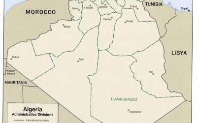
The coordinates of Algeria are approximately 28° to 37° North latitude and 8° to 12° East longitude. The country spans a vast area of about 2.38 million square kilometers, making it the 10th largest country worldwide. Its map features a prominent Mediterranean coastline along the north, the expansive Sahara Desert in the south, and the Atlas Mountains running parallel to the coast in the north-central regions.
- Map Overview:
- The northern part of Algeria features a narrow coastal plain known as the Tell Atlas, which is lush and densely populated.
- The Atlas Mountains extend across northern Algeria, elevating to peaks such as Mount Tahat, the highest point in the country at 2,908 meters.
- The Sahara Desert dominates the southern part, characterized by vast sand dunes, plateaus, and oases, including the Hoggar Mountains and Tassili n’Ajjer plateau.
- Major cities like Algiers, Oran, and Constantine are located along the Mediterranean coast, serving as cultural and economic hubs.
Bordering Countries
Algeria, located in North Africa, is the largest country on the continent, covering a vast area with diverse geographical features. It boasts a varied landscape that includes the expansive Sahara Desert in the south, the mountainous Atlas ranges in the north, and a Mediterranean coastline along the northwestern border. The country’s location significantly influences its climate, ecosystems, and natural resources.
- To the northeast, Algeria borders Tunisia and Libya, sharing borders across deserts and mountains.
- On the eastern side, it is bordered by Niger and Mali, with border regions characterized by desert landscapes.
- Southward, it shares borders with Mauritania, Western Sahara, and notably Morocco, with extensive desert regions in these areas.
- In the north, the Mediterranean Sea provides Algeria with a coastline that spans around 1,200 kilometers, facilitating maritime trade and cultural exchange.
Topography and Landscape
Algeria’s geography is marked by diverse topography and striking landscapes that shape the country’s climate and natural environment. From vast deserts to lush coastal plains, the varied terrain reflects a complex geological history. Understanding the topography and landscape of Algeria provides insight into its cultural, ecological, and economic significance within North Africa.
Mountain Ranges
Algeria’s geography is characterized by diverse topography and striking landscapes, shaped by its vast size and varied climate zones. The country features expansive deserts, rugged mountain ranges, fertile plains, and a lengthy Mediterranean coastline. The Atlas Mountain range is a dominant feature, stretching across the northern part of the country and including prominent subranges such as the Tell Atlas and Saharan Atlas. These mountains influence the climate and support various ecosystems, contrasting sharply with the arid Sahara Desert to the south. The Tell Atlas runs parallel to the Mediterranean coast, creating fertile coastal plains that are vital for agriculture and habitation. The Saharan Atlas, further inland, forms part of the larger Saharan Desert landscape, characterized by rocky plateaus, dunes, and sparse vegetation. Overall, Algeria’s topography significantly impacts its climate, biodiversity, and human activity, making it a country of contrasting landscapes and geographical features.
Plains and Plateaus
Algeria’s geography features a diverse and fascinating topography that includes vast plains and expansive plateaus. The plains, such as the Mitidja Plain near Algiers, are typically fertile areas suitable for agriculture and are often situated near the coast. In contrast, the plateaus, like the Hautes Plaines, are elevated flatlands that extend across central Algeria, characterized by a semi-arid climate and rugged terrain. These landforms contribute to the country’s varied landscape, shaping its climate, vegetation, and human settlements throughout the region.
Deserts and Oases
Algeria’s geography is characterized by diverse topography and striking landscapes that significantly influence its climate and ecosystems. The country features a vast coastal plains along the Mediterranean Sea, transitioning into the rugged Tell Atlas mountains in the north. In the interior, the high Plateaus and the Saharan region dominate the landscape, culminating in expansive deserts and semi-arid zones. The Sahara Desert covers a large portion of Algeria, featuring vast stretches of sand dunes, rocky plateaus, and gravel plains, creating a harsh yet mesmerizing environment.
Within the desert, oases are vital ecological and cultural hubs. These fertile areas, such as those at Ghardaïa or Timimoun, provide water and sustenance in an otherwise arid landscape, supporting agriculture and habitation. The oases often host date palms and other vegetation adapted to desert conditions, forming small but vibrant communities. These isolated pockets of greenery not only sustain local populations but also hold historical and economic significance, acting as trading points and cultural symbols of resilience amidst the challenging desert environment.
Major Landforms
Algeria, the largest country in Africa, features a diverse range of major landforms that shape its unique geography. From vast deserts to rugged mountains and expansive plains, these landforms influence the climate, ecological regions, and human activities across the country. Exploring Algeria’s major landforms provides valuable insights into its natural landscape and environmental features.
The Atlas Mountains
The Atlas Mountains are a major mountain range in northern Algeria, extending across several countries in North Africa. They serve as a significant geographical feature that influences the climate, biodiversity, and human activity in the region. The range stretches approximately 2,400 kilometers, from the Atlantic Ocean in Morocco through Algeria and Tunisia to Tunisia’s eastern coast. In Algeria, the Atlas Mountains are divided into various subranges, including the Tell Atlas near the coast and the Saharan Atlas further south. These mountains are characterized by rugged peaks, deep valleys, and diverse ecosystems. They play a crucial role in shaping the climate patterns of Algeria by blocking northern moist air and creating diverse weather conditions. Additionally, the Atlas Mountains are home to various plant and animal species, some of which are endemic to the region, contributing to Algeria’s rich natural heritage. The mountains also harbor vital water sources, including rivers and springs, which support agriculture and local communities in the surrounding areas. Overall, the Atlas Mountains are a defining landform that greatly impacts the physical and human geography of Algeria.
The Sahara Desert
The Sahara Desert, a vast and iconic landform, is a defining feature of Algeria’s geography. Covering much of northern Africa, it is the largest hot desert in the world, characterized by expansive dunes, gravel plains, and rocky plateaus. In Algeria, the Sahara extends across more than four-fifths of the country, shaping its climate, flora, fauna, and human settlement patterns. The desert’s extreme temperatures and arid conditions influence the landscape, creating unique geological formations such as sandstone plateaus, rock depressions, and oasis regions that support limited agriculture and indigenous lifestyles. The Sahara’s presence contributes to Algeria’s diverse landscape, making it a significant geographical major landform within the country.
The Tell Atlas
The Tell Atlas is a prominent mountain range in northern Algeria, forming a significant part of the country’s geography. It extends parallel to the Mediterranean coast, stretching across several regions and acting as a natural barrier between the coastal plains and the interior desert areas. The range is characterized by its rugged terrain, steep slopes, and numerous valleys, which support various ecosystems and agricultural activities. The Tell Atlas influences the climate of northern Algeria, bringing higher rainfall and milder temperatures compared to the arid regions further south. It is also a vital geographical feature that influences settlement patterns, transportation routes, and the overall landscape of the country.
Hydrography
Hydrography is the study of the distribution, movement, and properties of surface and subsurface water bodies. It plays a vital role in understanding the geographic features of a region, including rivers, lakes, and coastlines. In the context of Algeria, hydrography provides essential insights into the country’s water resources, influencing its environment, economy, and development planning.
Principal Rivers and Lakes
Hydrography in Algeria is characterized by a network of rivers and lakes that significantly influence the country’s climate and agriculture. The principal rivers include the Cheliff River, which is the longest river in the country, providing vital water resources for irrigation and domestic use. Other important rivers are the Medjerda, Seybouse, and Boudouaou, each contributing to regional water systems. Lakes in Algeria are primarily endorheic, meaning they do not drain into the sea, with notable examples such as Lake Chad, which extends into Algeria’s borders, and the highly saline Chott El Djerid, a large salt lake in the Sahara. These water bodies play a crucial role in the local ecosystem and support the diverse flora and fauna of the region, despite challenges posed by arid and semi-arid conditions.
Coastal Waters and Maritime Boundaries
Algeria’s geography is characterized by diverse hydrographic features, extensive coastal waters, and clearly defined maritime boundaries. The country is situated in North Africa and boasts a coastline along the Mediterranean Sea, which spans approximately 1,200 kilometers. This coastal region hosts a variety of inlets, bays, and beaches, supporting both economic activities and natural habitats. The hydrography of Algeria includes several major rivers such as the Chelif, the largest river in the country, as well as numerous smaller streams and wadis that drain the inland areas. These watercourses are crucial for agriculture, freshwater supply, and ecological diversity.
The coastal waters of Algeria are of strategic importance, providing access to maritime trade routes and supporting a lively fishing industry. The continental shelf along the Mediterranean is relatively broad in some areas, offering opportunities for offshore exploration and resource extraction. Algeria maintains well-defined maritime boundaries with neighboring countries, ensuring territorial sovereignty over its maritime zones. These boundaries are established in accordance with international maritime law and are vital for managing marine resources, environmental protection, and security in the region.
Oasis Water Sources
Hydrography in Algeria plays a vital role in shaping the country’s geography, influencing its climate, agriculture, and settlement patterns. The nation’s water resources include major rivers, lakes, and underground aquifers that are essential for domestic, agricultural, and industrial use. Despite its vast desert areas, Algeria has several oasis water sources that sustain local populations and support agriculture in arid regions.
Oasis water sources in Algeria are typically found in the Sahara Desert, where groundwater emerges to nourish scattered palm groves and settlements. These oases serve as vital hubs for communities and transport routes across the desert. Many of these water sources originate from ancient underground rivers and aquifers that have been recharged by sporadic rainfall and natural springs. Some prominent oasis water sources include the Tassili n’Ajjer region, Tamanrasset, and the Ghardaia area, where wells and springs provide continuous water supply despite the harsh desert conditions.
Climate and Ecosystems
Algeria’s diverse climate and rich ecosystems play a crucial role in shaping its geography. From the arid Sahara Desert in the south to the lush Mediterranean coast in the north, the country’s varying climate zones support a wide range of flora and fauna. These natural features influence human activities, agriculture, and the overall landscape of Algeria, making its geography uniquely dynamic and significant.
Climate Zones
Algeria’s geography is characterized by diverse climate zones and rich ecosystems. The northern region, along the Mediterranean coast, experiences a temperate Mediterranean climate with mild, wet winters and hot, dry summers, supporting lush forests, agricultural lands, and vibrant coastal ecosystems. Moving southward, the climate transitions into arid and semi-arid zones, dominated by the vast Sahara Desert, which features extreme temperatures, minimal rainfall, and unique desert ecosystems adapted to harsh conditions. The Saharan region is home to specialized flora and fauna capable of surviving in the extreme environment. In the highlands and mountain ranges such as the Tell Atlas and the Hoggar Mountains, the climate becomes cooler and more humid, creating pockets of forests and grasslands that support diverse wildlife. Algeria’s varied climate zones significantly influence its ecosystems, shaping the distribution of plant and animal species across the country.
Vegetation and Flora
Algeria’s geography is characterized by diverse climates and ecosystems, supporting a wide variety of vegetation and flora. The country spans from the Mediterranean coast to vast deserts and mountainous regions, creating distinct ecological zones.
- The coastal region features a Mediterranean climate with lush forests, including holm oak, Aleppo pine, and cork oak, supporting rich vegetation and diverse flora.
- In the Tell Atlas mountain range, the flora includes various shrubs, forests of cedar and juniper, and numerous endemic plant species adapted to cooler and more humid conditions.
- The Saharan desert region is dominated by sparse vegetation, mainly composed of drought-resistant plants such as acacias, succulents, and grasses that survive the harsh, arid environment.
- Oases scattered throughout the Sahara host lush green flora, including date palms, reeds, and other water-dependent plants, creating isolated pockets of greenery in an otherwise barren landscape.
The variety of ecosystems in Algeria supports a rich array of plant life, making it an important area for botanical diversity and conservation efforts. These ecosystems are crucial for maintaining ecological balance and supporting the livelihoods of local populations.
Fauna and Wildlife Habitats
Algeria’s geography is characterized by diverse climates and ecosystems that support a wide variety of fauna and wildlife habitats. The northern region features a Mediterranean coastline rich in forests, plains, and wetlands, providing habitat for numerous bird species and marine life. Moving south, the terrain transitions into the Sahara Desert, one of the largest hot deserts in the world, with unique desert-adapted flora and fauna such as foxes, camels, and various reptiles. The Saharan areas host oases that support sparse vegetation and serve as crucial habitats for migratory birds and desert wildlife. In the high plateaus and mountain ranges like the Atlas Mountains and the Saharan Atlas, the climate is more temperate, offering diverse ecosystems with shrublands, grasslands, and forests, which sustain species like deer, wild boars, and numerous bird species. Overall, Algeria’s varied geography creates a mosaic of habitats that are vital for the conservation of its rich biodiversity and ecological balance.
Environmental Concerns and Conservation
Algeria’s diverse geography, encompassing vast deserts, fertile plains, mountains, and a long Mediterranean coastline, presents both opportunities and challenges for environmental conservation. As the country faces increasing environmental concerns such as desertification, water scarcity, and habitat loss, sustainable practices and conservation efforts are essential to preserve its unique natural landscape. Understanding Algeria’s geographical features is key to implementing effective strategies that protect its environment for future generations.
Desertification Issues
Algeria’s vast and diverse geography presents significant environmental challenges, particularly concerning desertification and conservation. The expansive Sahara Desert covers much of the southern region, making it prone to the spread of desertification due to overgrazing, deforestation, and climate change. These processes threaten the land’s fertility, diminish agricultural productivity, and displace local communities. Efforts to combat these issues include reforestation initiatives, sustainable land management, and the promotion of water conservation practices. Protecting Algeria’s unique ecosystems and natural landscapes is crucial for maintaining biodiversity, supporting local livelihoods, and ensuring environmental stability for future generations.
Protected Areas and National Parks
Algeria’s diverse geography, which includes vast deserts, mountain ranges, and coastal regions, presents significant environmental concerns and opportunities for conservation. The arid Sahara Desert covers much of the southern part of the country, facing challenges such as desertification, soil erosion, and water scarcity. Protecting these fragile ecosystems is vital for maintaining biodiversity and supporting local communities. Algeria has established numerous protected areas and national parks to conserve its natural heritage, such as the Tassili n’Ajjer National Park, renowned for its unique rock formations and prehistoric cave paintings, and the Ahaggar National Park, home to the impressive Hoggar Mountains and endemic species. These protected regions serve both to preserve biodiversity and to promote eco-tourism, which can aid in sustainable development. Effective conservation efforts are essential to address environmental threats, ensure the longevity of Algeria’s natural landscapes, and balance ecological preservation with economic growth.


0 Comments