
Overview of Egypt’s Geography
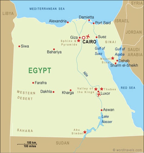
Egypt’s geography is characterized by its diverse landscapes and strategic location in northeastern Africa. The country is predominantly defined by the vast expanse of the Sahara Desert, which covers much of its territory, and the fertile Nile River valley that sustains its population. Bordered by the Mediterranean Sea to the north and the Red Sea to the east, Egypt’s geography has historically been a vital crossroads between Africa, Asia, and Europe, shaping its cultural and economic development.
Location and Boundaries
Egypt is a North African country known for its rich historical heritage and diverse geography. Located primarily in the northeastern corner of Africa, Egypt also includes the Sinai Peninsula, which is part of Asia. The country is characterized by vast deserts, fertile lands along the Nile River, and significant mountain ranges. Egypt’s strategic location connects Africa and the Middle East, serving as a cultural and geographical bridge.
Egypt is bordered by the Mediterranean Sea to the north, Libya to the west, Sudan to the south, and Israel and the Gaza Strip to the east. The Nile River, the longest river in the world, flows through the country from south to north, creating a fertile strip of land that supports its population and agriculture. The Sinai Peninsula acts as a land bridge between Africa and Asia, making Egypt a key geopolitical hub in the region.
Major Landforms
Egypt is a country located in the northeastern corner of Africa, with a rich and diverse geography that significantly influences its climate, agriculture, and culture. Its landscape is dominated by major landforms that define its physical character and historical significance.
- The Nile River: The most prominent feature of Egypt’s geography, the Nile River, flows south to north through the country, providing vital water resources and fertile lands along its valley, which supports agriculture and settlement.
- The Sahara Desert: Covering most of Egypt’s territory, the Sahara Desert forms a vast arid landscape characterized by dunes, rocky plateaus, and sparse vegetation, influencing climate and habitation patterns.
- The Eastern and Western Deserts: These are extensions of the Sahara, located on either side of the Nile Delta, with distinct features such as mountain ranges and oasis regions.
- The Nile Delta: A triangular-shaped fertile region where the Nile River spreads out and drains into the Mediterranean Sea, vital for agriculture and dense population centers.
- The Red Sea Coast: Located in the eastern part of Egypt, this coastal region includes coral reefs and beaches, serving as important hubs for trade and tourism.
Climate Zones
Egypt’s geography is predominantly characterized by the vast Sahara Desert, which covers most of the country, complemented by the fertile Nile River Valley and Delta. The Nile River, the longest in the world, flows through Egypt from south to north, providing essential water resources and supporting agriculture in an otherwise arid landscape. The northern coast features the Mediterranean Sea, offering a vital maritime connection.
Egypt’s climate varies across its regions but is generally classified as desert, featuring hot, dry summers and mild winters. The desert zones experience extreme temperatures during summer months, often exceeding 40°C (104°F). Along the Nile, the climate is more temperate, with cooler winters and pleasantly warm summers, fostering a more hospitable environment for human habitation.
The country can be divided into several climate zones: the arid Sahara Desert spanning most of the interior, the Mediterranean coastal strip with a semi-arid climate, and the Nile River Valley and Delta, which benefit from more moderate conditions due to the presence of water and vegetation. This diversity in climate zones influences not only the natural landscape but also the agricultural practices and settlement patterns across Egypt.
Main Regions of Egypt
Egypt is a country with diverse landscapes and rich cultural history, divided into several main regions. Each region offers unique geographic features, historical sites, and local traditions. Understanding the main regions of Egypt provides insight into the country’s geographical layout and cultural diversity. Exploring the Egypt map reveals these distinct areas, from the Nile Delta to the desert expanses and the Sinai Peninsula.
Cairo and the Nile Delta
The main regions of Egypt include Cairo and the Nile Delta, both of which are vital to the country’s geography and culture. Cairo, the capital city, is located in the northeastern part of Egypt and is a major political, economic, and cultural center. It is famous for its ancient history, vibrant markets, and historic sites like the Egyptian Museum and Islamic Cairo. The Nile Delta, on the other hand, is a fertile area where the Nile River splits into several branches before flowing into the Mediterranean Sea. This region covers the northern part of the country and is crucial for agriculture and population density. Both Cairo and the Nile Delta are prominently featured on Egypt maps, showcasing their significance in the nation’s landscape and development.
Upper Egypt (Southern Region)
The main region of Upper Egypt, located in the southern part of the country, is known for its rich history and unique cultural identity. It stretches from the area around Aswan up to the region near Luxor, encompassing some of Egypt’s most iconic archaeological sites, including the temples of Abu Simbel and Karnak. This region is characterized by its lush Nile River valley surrounded by desert, providing vital fertile land for agriculture. Upper Egypt has historically served as a center of ancient Egyptian civilization, with significant contributions to arts, religion, and governance. Today, it remains a vital area that reflects Egypt’s historical heritage while evolving as a hub for tourism and cultural preservation.
Western Desert and Oasis Towns
The main regions of Egypt include the Western Desert and numerous Oasis Towns, which are vital to the country’s geography and heritage. The Western Desert stretches across a vast area west of the Nile River, characterized by its arid landscape and unique natural features. It is part of the Sahara Desert and includes notable regions such as the Libyan Desert and the Gilf Kebir Plateau. These areas are sparsely populated, but they are important for archaeological discoveries and natural resources.
Within this expansive desert are several Oasis Towns that serve as key hubs for local communities and travelers. Famous oasis towns include Siwa, known for its ancient history and unique culture, and Bahariya, which boasts mineral springs and archaeological sites. Other significant oasis towns are Kharga and Dakhla, which provide vital access points within the Western Desert, supporting agriculture, tourism, and trade. These oases are lush enclaves amid the desert, offering a glimpse into Egypt’s diverse landscape and historical resilience.
Red Sea Coast and Sinai Peninsula
The Main Regions of Egypt, including the Red Sea Coast and Sinai Peninsula, are vital areas that showcase the country’s diverse geography. The Red Sea Coast stretches along Egypt’s eastern border, offering a vibrant strip of sandy beaches, stunning coral reefs, and thriving tourist resorts such as Hurghada and Sharm El Sheikh. This region is renowned for its marine life and is a popular destination for diving and snorkeling activities.
The Sinai Peninsula, located between the Red Sea and the Mediterranean Sea, is a mountainous desert region with significant historical and religious importance. It is home to Wadi al-Hitan, St. Catherine’s Monastery, and Mount Sinai, believed to be the site where Moses received the Ten Commandments. The peninsula features rugged landscapes, archaeological sites, and a strategic position that has shaped Egypt’s history for centuries.
Key Cities on the Map
Egypt is a country rich in history and culture, with its key cities playing vital roles in its development. These cities are not only centers of population and commerce but also serve as important landmarks that highlight the diverse geographical and cultural landscape of Egypt. Understanding the key cities on the map provides valuable insight into the nation’s heritage and modern-day significance.
Cairo
Cairo is one of the most prominent key cities on the Egypt map, serving as the capital and the largest city of the country. Located along the Nile River, it is a center of culture, history, and political activity in Egypt. Cairo is renowned for its ancient landmarks such as the pyramids of Giza and the Sphinx, as well as its vibrant markets, museums, and bustling urban life. Its strategic position makes it a vital hub for transportation and commerce within Egypt and the broader region.
Alexandria
Alexandria is one of the key cities depicted on the Egypt map, located along the Mediterranean coast. It is Egypt’s second-largest city and a major port, known for its rich history and cultural significance. The city features prominent landmarks such as the Library of Alexandria and the Qaitbay Citadel. Its strategic position has historically made it a vital hub for trade, education, and tourism in Egypt.
Luxor
Luxor is one of the key cities highlighted on the Egypt map, renowned for its rich history and cultural significance. Located on the east bank of the Nile River, Luxor is often referred to as an open-air museum due to its numerous ancient monuments and temples. It serves as a major tourist destination, attracting visitors interested in exploring attractions such as the Valley of the Kings, Karnak Temple, and Luxor Temple. The city plays a crucial role in Egypt’s archaeological heritage, making it a vital point of interest for anyone studying or traveling through Egypt.
Suez
Suez is a crucial city located in northeastern Egypt, situated at the northern end of the Gulf of Suez, near the Suez Canal. It serves as an important port and industrial hub, facilitating maritime trade between the Mediterranean and Red Seas. The city is strategically significant due to its proximity to the Suez Canal, one of the world’s most vital waterways for global shipping. Suez’s urban landscape features a mix of modern infrastructure and historical sites, reflecting its long-standing role in Egypt’s economic development. As a key city on the map of Egypt, Suez is a gateway that connects the northern and southern parts of the country, as well as international maritime routes.
Nile River and Its Significance
The Nile River, often considered the lifeblood of Egypt, is one of the longest rivers in the world, stretching over 4,000 miles through northeastern Africa. It has historically been vital for sustaining the civilization of ancient Egypt, providing water for agriculture, transportation, and supporting the local economy. The river’s significance continues to this day, shaping the geography and culture of the region. Understanding the Nile’s role is essential when exploring an Egypt map, as it highlights the central importance of this majestic waterway in shaping the nation’s landscape and history.
Course of the Nile
The Nile River is one of the longest and most historically significant rivers in the world, serving as the lifeblood of Egypt and surrounding regions. It has played a crucial role in the development of ancient civilizations, providing water, transportation, and fertile soil for agriculture along its banks.
The course of the Nile River begins in East Africa, with its primary sources being Lake Victoria and Lake Tana. It flows northward through Uganda, Ethiopia, Sudan, and South Sudan before entering Egypt. In Egypt, it traverses the length of the country, forming a lush valley amidst the desert landscapes, before finally emptying into the Mediterranean Sea. The river’s predictable annual flooding historically enabled ancient Egyptians to develop sophisticated farming systems and sustain a thriving civilization.
The Nile’s significance extends beyond agriculture; it supports Egypt’s water supply, hydroelectric power generation, and transportation networks. Its basin covers parts of eleven countries, making it a vital resource that influences regional economies and geopolitics. The Nile River remains central to Egypt’s map and cultural identity, symbolizing life and sustenance in the desert landscape.
Major Nile Tributaries
The Nile River is one of the longest and most vital rivers in the world, running through northeastern Africa and playing a crucial role in Egypt’s geography, economy, and culture. It serves as the primary source of water for agriculture, drinking, and transportation in the region. The Nile’s significance is deeply rooted in Egypt’s history, shaping ancient civilizations and continuing to influence modern life.
Major tributaries of the Nile River include several important rivers that contribute to its flow. These tributaries are essential for maintaining the river’s volume and support the diverse ecosystems along its course.
- The White Nile: Originates from Lake Victoria, primarily flowing through Uganda and South Sudan, and is considered the main source of the Nile’s water.
- The Blue Nile: Begins in Ethiopia’s Lake Tana and contributes the majority of the Nile’s silt and floodwaters, especially during the rainy season.
- The Atbarah River: Originates in Ethiopia and joins the White Nile near Sudan, adding to the flow before merging into the main Nile.
- The Sobat River: Flows from Ethiopia and South Sudan, joining the White Nile downstream and increasing its volume.
Understanding the Nile River and its tributaries is essential for comprehending Egypt’s map, as these water bodies have historically determined settlement patterns, agriculture zones, and regional development across Egypt and its neighboring countries.
Nile Delta and Its Fertile Land
The Nile River is one of the most significant and longest rivers in the world, stretching approximately 6,650 kilometers through northeastern Africa. It has been the lifeline of Egypt for thousands of years, providing essential water resources for agriculture, transportation, and daily life. The river’s annual flooding traditionally deposited rich silt onto the surrounding lands, fostering the development of a thriving civilization along its banks.
The Nile Delta, located where the river meets the Mediterranean Sea, is a vast and highly fertile area. It is characterized by a network of distributaries, marshlands, and rich alluvial soil that makes it ideal for farming. The delta’s fertile land has supported dense populations and agricultural activities for centuries, making it a vital region for Egypt’s economy and sustenance.
Within the map of Egypt, the Nile River and its delta dominate the landscape, illustrating their central role in the country’s geography and history. The river’s course from the highlands of central Africa to the Mediterranean Sea has shaped Egypt’s settlement patterns, culture, and development, emphasizing its importance as a natural resource that continues to sustain the nation today.
Geographical Features
Egypt, a country renowned for its rich history and diverse landscapes, boasts a variety of remarkable geographical features. From the vast Nile River that sustains its civilization to the deserts that cover much of the land, Egypt’s geography plays a crucial role in shaping its culture and ecosystem. Understanding these features provides valuable insight into the country’s unique environment and historical significance.
Sahara Desert
The Sahara Desert, a vast expanse of arid landscape, is one of the most defining geographical features of Egypt. Covering large portions of North Africa, it forms the natural northern boundary of the country and greatly influences its climate and ecosystem. The desert is characterized by its expansive sand dunes, rocky plateaus, and occasional dry riverbeds, known as wadis. Despite its harsh environment, the Sahara supports some adapted flora and fauna, and nearby oases provide crucial water sources for local populations. Understanding the Sahara’s geography is essential when studying Egypt’s map, as it shapes settlements, trade routes, and regional development across the country.
Eastern and Western Deserts
The Egyptian map features diverse geographical characteristics, notably including the Eastern and Western Deserts, which are two major desert regions that shape the country’s landscape. These deserts are expansive arid areas with unique features and significant importance to Egypt’s geography and culture.
The Eastern Desert lies between the Nile River Valley and the Red Sea. It is characterized by rugged mountains, granite formations, and wadis (dry riverbeds). This desert is rich in mineral resources, including gold, and has numerous historical sites and ancient trade routes. The terrain is mostly mountainous and hilly, making it less accessible than the Western Desert but crucial for mining and tourism.
The Western Desert extends west of the Nile River and covers about two-thirds of Egypt’s land area. It is a vast, flat, and arid region with extensive sand dunes, rocky plateaus, and oasis towns. The Western Desert serves as a natural barrier and features several important oases, such as Siwa and Bahariya, which sustain local populations and agriculture. Its expansive dunes and desert plains highlight Egypt’s desert environment and influence its climate and settlement patterns.
Overall, the Eastern and Western Deserts are vital geographical features of Egypt, shaping the movement, settlement, and economic activities within the country, as seen on the Egyptian map.
Mountain Ranges
Egypt’s geography is characterized by the presence of several significant mountain ranges that shape its landscape. While much of Egypt is dominated by the vast Sahara Desert, the eastern and southern regions feature notable mountainous areas. The Eastern Desert contains ranges like the Eastern Desert Mountains, which run parallel to the Red Sea and include peaks such as Mount Saint Catherine, the highest point in Egypt. The mountains in this region are rugged and often serve as natural barriers and sources of mineral wealth. In the southern part of Egypt, the Nag Hammadi Mountains are notable for their unique geological formations. These mountain ranges contribute to the diverse terrain depicted on the Egypt map, highlighting the contrast between the expansive deserts and the elevated terrains that influence climate and settlement patterns.
Oases and Valleys
Egypt’s landscape is characterized by a diverse array of geographical features, including vast deserts, fertile valleys, and vital oases. The defining feature is the Nile River, which flows through the heart of the country, creating a narrow strip of lush, arable land amidst arid surroundings. Along its course, the Nile has carved out numerous valleys essential for agriculture and settlement.
Oases are scattered throughout Egypt’s desert regions, serving as vital centers of life and trade. These fertile spots are sustained by underground water sources and provide habitat for various plant and animal species. Notable oases such as Siwa and Bahariya are significant both historically and economically.
Egypt’s valleys, particularly the Nile Valley, are crucial for civilization and development. These valleys act as natural corridors that support agriculture, transportation, and population centers. The contrast between the fertile valleys and the surrounding deserts highlights the importance of these geographical features in shaping Egypt’s culture and economy.
Tourist Attractions Mapped
Exploring Egypt offers an incredible journey through history, culture, and natural beauty. The Egypt map highlights some of the most renowned tourist attractions, from ancient pyramids and majestic temples to vibrant cities and scenic landscapes. Navigating these sites provides visitors with a deeper understanding of Egypt’s rich heritage and diverse destinations.
Ancient Monuments along the Nile
The Egypt map highlights numerous tourist attractions along the Nile, showcasing its rich history and cultural significance. Ancient monuments along the Nile are some of the most fascinating and iconic sites in Egypt. These monuments offer a glimpse into the grandeur of ancient Egyptian civilization and attract millions of visitors each year.
- Great Pyramids of Giza: The only remaining wonder of the Seven Wonders of the Ancient World, these pyramids are located near Cairo and symbolize ancient Egypt’s architectural brilliance.
- Luxor Temple: An extraordinary complex located in Luxor, it was dedicated to the gods Amun, Mut, and Khonsu and is a prime example of New Kingdom architecture.
- Valley of the Kings: Situated on the west bank of Luxor, this necropolis contains tombs of pharaohs like Tutankhamun and Ramses the Great.
- Philae Temple: Dedicated to the goddess Isis, this temple complex on Philae Island is renowned for its stunning architecture and historical significance.
- Aswan High Dam: While more modern, this engineering marvel also marks the Nile and has a viewing area featuring ancient temples relocated during its construction.
Red Sea Resorts
The Egypt map highlights many renowned tourist attractions along the Red Sea Resorts, making it a popular destination for travelers seeking both relaxation and adventure. These resorts are known for their stunning beaches, vibrant coral reefs, and abundant marine life, offering excellent opportunities for snorkeling, scuba diving, and water sports.
Some of the most prominent Red Sea Resorts on the Egypt map include Hurghada, Sharm El Sheikh, and Marsa Alam. Hurghada is famous for its lively nightlife and extensive coral reefs, while Sharm El Sheikh boasts world-class diving spots like the Ras Mohammed National Park. Marsa Alam is gaining popularity for its pristine beaches and unspoiled diving sites.
The Egypt map also showcases historical sites close to these coastal areas, such as ancient temples and archaeological ruins, providing a unique blend of cultural exploration and seaside leisure. Visitors to these resorts can enjoy a range of activities, from exploring underwater ecosystems to experiencing local markets and traditional cuisine.
Desert Safaris and National Parks
The Egypt map highlights some of the most exciting tourist attractions, desert safaris, and national parks that showcase the country’s rich history and diverse landscape. Visitors can explore ancient monuments, expansive deserts, and protected natural areas that offer unique experiences and spectacular scenery.
- The Pyramids of Giza and the Sphinx, iconic symbols of Egypt’s ancient civilization.
- The Luxor Temple and the Valley of the Kings, home to Pharaonic tombs and temples.
- The Egyptian Museum in Cairo, displaying an extensive collection of artifacts from Egypt’s history.
- Famous desert safaris across the Sahara Desert, offering adventures on quad bikes, camels, or 4×4 vehicles.
- The White Desert, known for its surreal white rock formations and unique landscapes.
- Ras Mohamed National Park, renowned for its vibrant coral reefs and marine life.
- Safari opportunities in the Eastern Desert, blending adventure with scenic desert views.



0 Comments