
Geographical Overview of Mauritius
Mauritius is an island nation located in the Indian Ocean, off the southeastern coast of Africa. Known for its stunning beaches, vibrant coral reefs, and lush green landscapes, it covers an area of approximately 2,040 square kilometers. The island’s diverse geography includes volcanic mountains, fertile plains, and coastal regions, making it a unique and picturesque destination. Its strategic location and rich natural features contribute to its importance as a popular tourist destination and a vibrant cultural hub.
Location and Coordinates
The map of Mauritius highlights the island nation’s geographical setting as an eastern island in the Indian Ocean. Located approximately 2,000 kilometers southeast of the continent of Africa, Mauritius is part of the Mascarene Islands group, which also includes Rodrigues, Agalega, and Cargados Carajos Shoals. The country is situated at coordinates around 20° South latitude and 57° East longitude, providing it with a tropical maritime climate and diverse landscapes including beaches, coral reefs, and lush inland mountains.
Size and Boundaries
The map of Mauritius showcases a small island nation located in the Indian Ocean, east of the coast of Madagascar. It is characterized by its diverse landscapes, including mountains, beaches, and plains. Covering an area of approximately 2,040 square kilometers, Mauritius is one of the most densely populated islands in the world. The country is bounded by the Indian Ocean on all sides, with no land borders with other countries. Its strategic location has historically made it an important maritime hub. The island’s geography features the central plateau, volcanic mountains such as Piton de la Petite Rivière Noire, and coastal lagoons that contribute to its picturesque scenery.
Topography and Landscape
The map of Mauritius reveals a diverse geographical landscape that is characterized by its volcanic origins and lush terrain. Located in the Indian Ocean, east of Madagascar, the island boasts a variety of topographical features that shape its distinctive scenery. The island’s highest point is Piton de la Petite Rivière Noire, which stands at 828 meters above sea level, offering spectacular views and rugged terrain. The landscape includes rolling hills, fertile plains, and rugged mountain ranges, alongside beautiful coastal areas with sandy beaches and coral reefs. The interior of Mauritius is marked by dense forests and volcanic formations, while the coastlines are dotted with lagoons and coral atolls, making it a picturesque and ecologically rich destination.
Major Regions and Divisions
The map of Mauritius is divided into several major regions and divisions that help organize the island’s diverse landscape and administrative areas. Understanding these regions provides valuable insights into the geographic, cultural, and economic aspects of the country. Each division plays a significant role in shaping the identity and functionality of Mauritius as a vibrant island nation.
Northern Region
The Northern Region of Mauritius is one of the major divisions on the island, known for its vibrant towns and scenic landscapes. This area includes key towns such as Grand Baie, which is famous for its lively nightlife and beaches, as well as Cap Malheureux with its picturesque red-roofed church. The Northern Region is characterized by lush greenery, beautiful coastlines, and popular tourist destinations. It also serves as a hub for cultural and recreational activities, attracting visitors from around the world. The map of Mauritius highlights the Northern Region’s strategic location and its importance in the overall layout of the island.
Southern Region
The Southern Region of Mauritius is one of the major divisions on the map, known for its diverse landscapes and cultural attractions. It encompasses important towns and areas such as Bel Ombre, Gris Gris, and Le Morne. This region is renowned for its stunning beaches, including the famous Le Morne Peninsula, which is designated as a UNESCO World Heritage Site. The Southern Region also features lush sugarcane plantations, vibrant local markets, and historical sites that reflect the rich heritage of Mauritius. Visitors to this area can enjoy a mix of natural beauty and cultural experiences, making it a key part of the map of Mauritius.
Eastern Region
The Eastern Region of Mauritius is one of the major divisions on the map of the island, known for its diverse landscapes and cultural attractions.
- Grand Bay: A popular tourist destination famous for its beaches and nightlife.
- Pointe aux Piments: Known for its turquoise waters and vibrant marine life.
- Trou aux Biches: Renowned for its pristine white sandy beaches and luxury resorts.
- Belle Mare: Famous for its long beaches and stunning coral reefs.
- Palmar: A picturesque village with lush surroundings and traditional Mauritian charm.
Western Region
The Western Region of Mauritius is one of the major divisions on the island, known for its diverse landscapes and vibrant communities. It encompasses several key areas that contribute to the region’s cultural and economic significance.
- Port Louis: The capital city and economic hub of Mauritius, featuring bustling markets and historic sites.
- Curepipe: Known for its cool climate and central location, offering picturesque landscapes and markets.
- Flic en Flac: A popular coastal village famous for its pristine beaches and vibrant nightlife.
- Quatre Bornes: A lively town renowned for its shopping centers and local markets.
- Le Morne: A UNESCO World Heritage site with a stunning mountain and historical significance.
Central Plateau
The Central Plateau of Mauritius is a significant region characterized by its elevated terrain and fertile lands. It is one of the main divisions of the island, offering a contrast to the coastal regions with its cooler climate and rolling hills. This area is home to many towns and villages, serving as an important cultural and economic hub. The Central Plateau is also known for its scenic landscapes, agricultural activities, and historical sites, making it a vital part of the country’s overall map. Understanding this region provides insights into the diverse geography and regional distinctions within Mauritius.
Main Islands and Archipelagos
Main islands and archipelagos are fascinating geographical features that showcase the diversity of our planet’s landscapes. These landmasses are often formed through volcanic activity, tectonic movements, or coral growth, creating unique ecosystems and cultural histories. Understanding their layout is essential for navigation, conservation, and exploring regional connections. In the context of Mauritius, exploring the main islands and surrounding archipelagos offers insight into the area’s natural beauty and geographic significance.
Mahebourg and Grande Rivière Sud-Est
The main islands and archipelagos of Mauritius are diverse and offer unique landscapes and ecosystems for visitors to explore. Mahebourg, a historic town on the southeastern coast, serves as a vibrant gateway to the island’s cultural heritage and nearby islands. Grande Rivière Sud-Est is a picturesque area known for its lush green scenery, waterfalls, and serene beaches, making it a popular destination for nature lovers. These locations, along with the surrounding archipelagos, contribute to the rich geographical tapestry of Mauritius, which is well depicted on maps of the island.
Île aux Cerfs
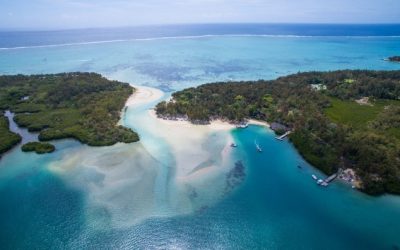
The map of Mauritius highlights its main islands and archipelagos, offering a comprehensive view of the region’s diverse geography. Among the prominent islands are Mauritius Island itself, along with the nearby Île aux Cerfs, a small island renowned for its stunning beaches and recreational facilities. The archipelagos surrounding Mauritius include the Île aux Aigrettes and Île aux Serpents, each contributing to the island nation’s rich biodiversity and ecological significance. These islands are popular destinations for tourists seeking natural beauty, water sports, and relaxation. Navigating the map reveals the strategic location of Île aux Cerfs, which lies off the east coast of Mauritius, making it easily accessible for day trips from the main island. Overall, the map showcases the beautiful interconnected islands and archipelagos that define Mauritius as a tropical paradise.
Île aux Serpents
The map of Mauritius showcases its main islands and surrounding archipelagos, highlighting the diverse and captivating geography of the region. The primary island, Mauritius, is known for its stunning beaches, vibrant coral reefs, and lush interior landscapes. Nearby, the Île aux Serpents, or Snake Island, is a smaller, uninhabited island famous for its rich biodiversity and ecological significance. Additionally, the archipelagos surrounding Mauritius include the Agalega Islands and Cargados Carajos Shoals, which contribute to the archipelago’s ecological and maritime importance. These islands and archipelagos collectively form a vital part of the Mauritian maritime territory, offering unique habitats and opportunities for tourism, conservation, and scientific research.
Key Cities and Urban Areas
Key cities and urban areas in Mauritius play a vital role in the island’s social, economic, and cultural landscape. These urban centers serve as hubs of commerce, tourism, and community life, contributing to the overall development of the nation. Understanding the distribution and significance of these cities is essential when exploring a map of Mauritius and appreciating its diverse regional characteristics.
Port Louis
Port Louis is the capital and largest city of Mauritius, serving as the main urban hub on the island. As the economic, political, and cultural center, it plays a vital role in the country’s development and offers a glimpse into urban life in Mauritius.
- Key Cities in Mauritius include Port Louis, Beau Bassin-Rose Hill, and Vacoas-Phoenix.
- Urban areas are concentrated mainly along the coast, where infrastructure and amenities are more developed.
- Port Louis features a busy port, historic sites, markets, and government offices, making it a focal point for both residents and visitors.
- The city is also notable for its diverse culture and vibrant markets, reflecting the multicultural makeup of Mauritius.
- Mapping Port Louis on a map of Mauritius provides insight into its strategic location and connectivity to other parts of the island.
Rose Hill (Curepipe)
Rose Hill, located in the Curepipe District, is a significant urban area in Mauritius. It forms part of the greater urban landscape surrounding the capital city, Port Louis. As a key city, Rose Hill contributes to the country’s economic and social activities, providing residential and commercial spaces that support the region’s development. Its strategic location and infrastructure make it an important hub within the map of Mauritius, connecting various parts of the island and facilitating transportation and commerce. Understanding the urban areas like Rose Hill is essential for appreciating the geographic and demographic layout of Mauritius.
Quatre Bornes
Quatre Bornes is a prominent city located in the western part of Mauritius and is one of the key urban areas on the island. Known for its vibrant markets, bustling streets, and cultural diversity, Quatre Bornes plays a significant role in the country’s social and economic life. As part of the island’s urban landscape, it is closely connected to other major cities like Port Louis, the capital, and Curepipe. The city boasts a mix of residential, commercial, and recreational zones, making it a vital hub for commerce and community activities. Its strategic location and development make Quatre Bornes an essential component of Mauritius’s overall map of key cities and urban areas.
Mahébourg
Mahébourg is a key city and urban area located on the southeastern coast of Mauritius. Known for its rich history and vibrant culture, it serves as an important hub for tourism and local commerce. The city is near the historic Mahebourg Museum and offers access to beautiful seaside views and scenic landscapes. As a significant urban center, Mahébourg contributes to the overall map of Mauritius by showcasing the island’s coastal charm and historical significance.
Natural Features and Landmarks
Mauritius is a beautiful island nation renowned for its diverse natural features and impressive landmarks. From lush mountains and vibrant coral reefs to breathtaking waterfalls and protected parks, the island offers a rich tapestry of natural beauty. Exploring these natural features provides insight into the unique landscape that makes Mauritius a captivating destination for travelers and nature enthusiasts alike.
Mountain Ranges and Peaks
Mauritius is renowned for its stunning natural features and iconic landmarks that define its landscape. The island is characterized by lush mountains, vibrant peaks, and expansive mountain ranges that attract visitors from around the world. One of the most notable mountain ranges is the Morne Mountains, which run along the central part of the island, offering breathtaking views and hiking opportunities. The island’s highest peak is Piton de la Petite Rivière Noire, standing at approximately 828 meters, providing panoramic vistas of Mauritius. Other prominent peaks include Le Morne Brabant, a UNESCO World Heritage site famous for its historical significance and dramatic cliffs. These natural features and mountain landmarks contribute to the island’s diverse terrain and scenic beauty, making Mauritius a captivating destination for nature lovers and explorers alike.
Rivers and Waterfalls
Map of Mauritius features a diverse array of natural landmarks, including lush mountains, pristine beaches, and vibrant coral reefs. The island is renowned for its stunning waterfalls such as Chamarel Falls and Rochester Falls, which attract many visitors. Rivers like the Grand River South East and the Black River flow through the landscape, providing vital water resources and adding to the island’s scenic beauty. These natural features play a significant role in shaping the geography of Mauritius and contribute to its reputation as a tropical paradise.
Beaches and Coastal Features
The map of Mauritius showcases a variety of natural features and landmarks that define the island’s unique geography. From its stunning beaches to its diverse coastal formations, these features attract visitors and contribute to the island’s natural beauty.
Beaches and Coastal Features of Mauritius
- White Sandy Beaches: Mauritius is famed for its pristine white sandy beaches such as Belle Mare, Flic en Flac, and Trou aux Biches, offering perfect spots for relaxation and water sports.
- Coral Reefs: The surrounding coral reefs provide natural protection for the islands’ shores and are popular for snorkeling and diving adventures.
- Turquoise Lagoons: Shallow, clear lagoons like those at Île aux Cerfs create ideal conditions for swimming and sunbathing.
- Coastal Cliffs and Promontories: Notable formations include Le Morne Brabant, a UNESCO World Heritage site, characterized by dramatic cliffs overlooking the ocean.
- Natural Piers and Rock Formations: Unique rock structures along the coast, such as the Cathedral and the Seven Coloured Earth at Chamarel, enhance the island’s scenic landscape.
Protected Areas and National Parks
The map of Mauritius highlights the island’s diverse natural features, landmarks, protected areas, and national parks that showcase its rich biodiversity and scenic beauty.
- Le Morne Brabant: A UNESCO World Heritage Site known for its stunning mountain and historical significance.
- Black River Gorges National Park: A protected area covering lush forests, waterfalls, and endemic wildlife.
- Chamarel Geothermal Park: Famous for the Seven Colored Earths and cascading waterfalls.
- La Plantation de Bois Chéri: A famous tea plantation offering scenic views and cultural insights.
- Flic en Flac Marine Park: A vibrant underwater reserve with coral reefs and diverse marine life.
These natural features and protected areas are essential for conservation efforts and tourism, providing visitors with breathtaking landscapes and opportunities for adventure and exploration on the island of Mauritius.
Transport and Accessibility
Transport and accessibility are vital components of any destination, shaping the ease with which visitors and residents can explore and connect. In the context of Mauritius, a stunning island nation known for its diverse landscapes and vibrant culture, an effective transportation network enhances travel experiences and accessibility to various attractions. Understanding the map of Mauritius provides valuable insights into the different modes of transport available and how they facilitate smooth movement across the island.
Road Network
The road network in Mauritius forms a crucial part of the island’s transport and accessibility infrastructure, facilitating movement across urban, suburban, and rural areas. Well-developed roads connect major towns, tourist sites, and economic centers, ensuring efficient transportation for residents and visitors alike. The primary highways, including the M1, M2, and M3 routes, serve as main arteries linking the capital city, Port Louis, with other regions. Additionally, secondary roads and local streets extend access to more remote locations, enhancing connectivity throughout the island. The road network is continually maintained and expanded to support tourism, commerce, and daily commuting, making Mauritius a well-connected destination within the Indian Ocean. This comprehensive road system is vital for promoting economic growth and ensuring easy accessibility to all parts of the island as mapped out in the Mauritius map.
Ports and Maritime Routes
Transport and accessibility are vital components of Mauritius’s infrastructure, ensuring smooth movement of people and goods across the island. The country boasts a well-developed road network that connects major towns, tourist destinations, and industrial zones, facilitating domestic travel and commerce.
Ports and maritime routes play a crucial role in Mauritius’s connectivity with the global market. The Port Louis Harbour, one of the busiest ports in the Indian Ocean, handles significant cargo and passenger traffic, serving as a gateway for imports and exports. Additionally, maritime routes linking Mauritius to neighboring islands, Africa, Asia, and beyond promote international trade and tourism.
Maritime transportation includes passenger ferries and cargo ships that leverage the strategic location of Mauritius to enable efficient shipping routes. The country’s ports are continually upgraded to support growing maritime activities, enhancing access and supporting the island’s economic development.
Airports and Aviation
Transport and accessibility are vital components of understanding the map of Mauritius, ensuring visitors can easily navigate the island. The country boasts a well-developed network of roads and public transportation options that connect major towns and tourist destinations seamlessly. Airports and aviation services play a crucial role in facilitating international travel, with Sir Seewoosagur Ramgoolam International Airport serving as the primary gateway to Mauritius. This airport offers numerous domestic and international flights, connecting the island with destinations across Africa, Europe, Asia, and beyond. Efficient transportation infrastructure enhances the accessibility of key sites and supports the island’s tourism industry, making Mauritius an easily reachable and navigable destination for travelers worldwide.
Map Usage and Practical Applications
Maps are essential tools that help us navigate and understand the world around us. They provide visual representations of geographic areas, allowing for better planning, exploration, and decision-making. In the context of Mauritius, a detailed map offers valuable insights into its landscapes, infrastructure, and cultural landmarks, making it a practical resource for travelers, educators, and researchers alike.
Tourism and Navigation
The map of Mauritius serves as an essential tool for both tourists and locals to explore the island’s diverse landscapes and attractions efficiently. It provides a visual overview of key locations, including beaches, natural parks, cultural sites, and urban centers, facilitating easier planning of travel itineraries. By using detailed maps, visitors can navigate effortlessly through winding roads and remote areas, ensuring they make the most of their visit. Additionally, map applications enhance the experience by offering real-time updates, directions, and points of interest, streamlining the process of exploration.
In the realm of tourism and navigation, maps of Mauritius play a crucial role in promoting the island as a travel destination. They help tourists discover hidden gems and popular hotspots alike, encouraging smooth travel experiences and increased safety. Moreover, these maps support local businesses and tourism operators by guiding visitors toward their services. Whether accessed digitally or in print, maps are vital tools that enrich the tourism experience, making Mauritius a more accessible and enjoyable destination for travelers from around the world.
Geographical Planning and Development
The map of Mauritius is an essential tool for various practical applications, especially in geographical planning and development. By providing detailed information about the island’s topography, land use, and infrastructure, maps facilitate effective decision-making for urban planning, transportation networks, and environmental conservation. They enable planners to identify optimal locations for new developments while considering ecological and socio-economic factors. Moreover, maps of Mauritius support disaster management by outlining vulnerable areas and resources, ensuring preparedness and efficient response strategies. In the context of tourism, detailed maps enhance visitor experience by highlighting attractions, facilities, and routes, contributing to sustainable tourism development. Overall, maps are indispensable in shaping the sustainable growth and development of Mauritius, balancing economic progress with environmental preservation.
Academic and Research Purposes
The map of Mauritius serves as a vital tool for both practical and academic purposes, providing comprehensive geographic information about the island nation. It enables travelers, locals, and researchers to navigate the terrain effectively, highlighting key locations such as cities, landmarks, natural features, and infrastructural networks. In academic and research contexts, the map facilitates spatial analysis, environmental studies, urban planning, and archaeological investigations by offering detailed visual representations of geographic data. Additionally, it aids in the study of demographic distribution, resource management, and ecological conservation efforts, making it an indispensable resource for understanding the diverse aspects of Mauritius.

0 Comments