

Geographical Features of Tanzania
Tanzania is a country renowned for its diverse and striking geographical features that shape its landscape. From vast plains and expansive savannas to towering mountains and deep lakes, the country’s terrain offers a rich tapestry of natural beauty. These features play a vital role in the nation’s ecosystems, climate, and cultural heritage, making Tanzania a fascinating subject for exploring its map and physical geography.
Mountains and Highlands
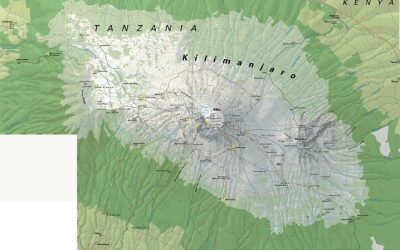
Tanzania is renowned for its diverse geographical features, especially its prominent mountains and highlands. The country is home to some of Africa’s most significant mountain ranges and elevated terrains, which form a vital part of its landscape. The most famous of these is Mount Kilimanjaro, the highest peak in Africa, towering at 5,895 meters above sea level. It attracts many climbers and adventurers from around the world. Besides Kilimanjaro, Tanzania features the Eastern Arc Mountains, which run parallel to the Indian Ocean and support rich biodiversity. The Central Highlands, located in the northern part of the country, include volcanic mountains and fertile plains that are essential for agriculture. Overall, these mountainous regions and highlands greatly influence the climate, ecosystems, and human activities across Tanzania.”
Rivers and Lakes
Tanzania is renowned for its diverse geographical features, including a variety of rivers and lakes that play a crucial role in its ecosystem and economy. The country is characterized by highlands, plains, and coastal regions, creating a rich landscape for wildlife and agriculture.
The Great Rift Valley bisects Tanzania from north to south, hosting several significant lakes such as Lake Victoria, Lake Tanganyika, and Lake Nyasa (Malawi). Lake Victoria, the largest lake in Africa and the second-largest freshwater lake in the world, borders Tanzania to the north and west. Lake Tanganyika, one of the deepest freshwater lakes globally, lies along the western border. Lake Nyasa, also known as Lake Malawi, is situated in the southern part of the country.
Tanzania’s major rivers include the Rufiji River, which is the longest river in the country and flows through the Selous Game Reserve, supporting diverse wildlife. The Ruvuma River marks the border with Mozambique, while the Pangani River drains the northeastern highlands into the Indian Ocean. These rivers contribute significantly to agriculture, hydroelectric power, and transportation within the region.
Overall, Tanzania’s rich network of lakes and rivers not only defines its geography but also sustains its biodiversity, supports local communities, and enhances its status as a prominent destination for nature tourism.
Coastal Areas and Islands
Tanzania is renowned for its diverse geographical features, including extensive coastal areas and islands that add to the country’s natural beauty. The eastern coastline along the Indian Ocean stretches over 800 kilometers, featuring sandy beaches, coral reefs, and mangrove forests. These coastal zones support rich marine life and vibrant fishing communities. Tanzania’s island landscape is equally remarkable, with major islands such as Zanzibar, Pemba, and Mafia. Zanzibar, famous for its historic Stone Town and spice farms, is a popular tourist destination. Pemba Island is known for its lush landscapes and diving spots, while Mafia Island offers pristine beaches and rich marine biodiversity. Overall, Tanzania’s coastal areas and islands contribute significantly to its ecological and economic landscape, making it a key feature on the Tanzania map.
Political and Administrative Divisions
The political and administrative divisions of Tanzania play a crucial role in organizing the country’s governance and regional management. These divisions help facilitate local administration, development planning, and resource distribution across the nation. Understanding the map of Tanzania offers valuable insights into how the country is structured geographically and administratively, highlighting its diverse regions and local government units.
Regions of Tanzania
Tanzania is divided into several political and administrative regions, each serving as a key unit for local governance and administrative purposes. These regions help in decentralizing authority and delivering government services effectively across the country. Tanzania’s map highlights these regions, which are further subdivided into districts, wards, and villages. The regions are spread across the mainland and the Zanzibar archipelago, reflecting the country’s diverse geographical landscape. This administrative structure ensures organized development, resource management, and political representation for the people of Tanzania. The official map of Tanzania showcases these divisions clearly, providing a visual understanding of the country’s territorial organization.
Major Cities and Urban Centers
Tanzania is divided into several political and administrative regions that help organize its governance and regional development. The country consists of 31 regions, each governed by a Regional Commissioner appointed by the central government. These regions are further subdivided into districts, wards, and neighborhoods, reflecting the nation’s administrative structure. Major cities in Tanzania serve as economic, political, and cultural hubs. Dar es Salaam, the largest city, functions as the commercial capital and is home to many industries, government offices, and educational institutions. Dodoma is the political capital where the government institutions are primarily located. Other significant urban centers include Arusha, known for tourism and international organizations, Mwanza, a key city on Lake Victoria, and Mbeya in the southwestern region, important for agriculture and trade. These urban centers are vital to Tanzania’s growth, serving as focal points for connectivity, commerce, and cultural exchange within the country.
Districts and Local Boundaries
Tanzania is divided into several political and administrative units, with districts serving as fundamental administrative divisions within each region. These districts facilitate local governance, resource distribution, and administrative functions across the country. The country’s administrative boundaries are delineated through a detailed mapping system, which helps in managing local development projects and civil services effectively. The map of Tanzania highlights various districts, each with its own boundaries, contributing to the nation’s organized political structure. These divisions are crucial for electoral processes, public administration, and regional planning, ensuring that administrative services reach every part of the country efficiently.
Topographical Landscape
The topographical landscape of Tanzania is characterized by diverse and breathtaking features that shape the country’s geography. From vast plains and rolling hills to towering mountains and expansive lakes, Tanzania’s terrain offers a stunning variety of natural landscapes. Understanding this topography is essential to appreciating the country’s rich ecosystems, wildlife habitats, and cultural regions depicted on the Tanzania map.
Plateaus and Plains
Tanzania’s map features a diverse topographical landscape that includes extensive plateaus and plains, contributing to its unique geographical identity. The country’s central region is dominated by the East African Plateau, which occupies a significant portion of mainland Tanzania. This highland area is characterized by rolling hills and elevated plateaus that support various ecosystems and settlements. Surrounding the plateau are vast plains, particularly in the Serengeti region, famous for its expansive grasslands that sustain abundant wildlife and are crucial for grazing and agriculture. Additionally, the coastal areas and the Great Rift Valley introduce varied terrains, including lower-lying plains and fertile lands. The combination of these landforms creates a rich and diverse landscape, making Tanzania a geographically significant country in East Africa.
Valleys and Depressions
Tanzania’s topographical landscape is characterized by a diverse array of valleys and depressions that contribute to its unique geographical features. These valleys serve as vital ecological zones, supporting rich biodiversity and agricultural activities, while also influencing the climate and weather patterns across the region. The Great Rift Valley, a prominent feature in Tanzania, extends through the country, creating a series of deep valleys and escarpments that are significant for both their natural beauty and geological importance. Depressions such as the Lake Tanganyika basin lie at lower elevations, forming vast natural reservoirs that are crucial for water resources and habitat diversity. Overall, these landforms play a key role in shaping Tanzania’s environment and regional landscape, making them a prominent aspect of the country’s map and geographical study.
Elevation Variations
Tanzania’s map showcases a diverse topographical landscape characterized by significant elevation variations across the country. The region features highlands, plateaus, lowlands, and coastal plains, each contributing to the country’s unique terrain. The African Great Lakes area, including Lake Victoria and Lake Tanganyika, lies in the lower elevations, while the East African Rift Valley spans through Tanzania, creating extensive rift valleys and volcanic mountains. Notably, Mount Kilimanjaro, the highest peak in Africa, reaches an elevation of 5,895 meters, marking the highest point in the country’s topography. These elevation variations influence climate patterns, biodiversity, and human settlement, making Tanzania’s landscape remarkably complex and diverse.
Natural Reserves and Protected Areas
Natural reserves and protected areas play a vital role in preserving the rich biodiversity and unique landscapes of Tanzania. These areas are designated to safeguard wildlife, plant species, and ecosystems, ensuring their sustainability for future generations. Tanzania’s map highlights various national parks and protected zones that attract eco-tourists and researchers alike, showcasing the country’s commitment to conservation and environmental preservation.
Serengeti National Park
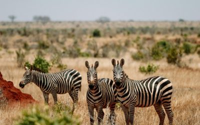
The Serengeti National Park in Tanzania is one of the world’s most renowned natural reserves, celebrated for its stunning landscapes and diverse wildlife. Located in northern Tanzania, it spans over 14,750 square kilometers and is a vital part of the Serengeti ecosystem, which supports the annual migration of over two million wildebeest and hundreds of thousands of zebras and gazelles. The park plays a crucial role in conservation efforts, safeguarding numerous species and their habitats beneath a protected area framework. As a UNESCO World Heritage Site, Serengeti exemplifies Tanzania’s commitment to preserving its rich natural heritage while offering exceptional opportunities for eco-tourism and scientific research. This reserve, along with other protected areas in Tanzania, is strategically marked on the Tanzania map, emphasizing its importance within the broader network of natural reserves across the country.
Ngorongoro Conservation Area
The Ngorongoro Conservation Area is one of Tanzania’s most renowned natural reserves, offering a stunning example of biodiversity and conservation efforts in East Africa. Located in the northern part of Tanzania, it is part of the Serengeti ecosystem and is famous for the Ngorongoro Crater, a UNESCO World Heritage Site that hosts a wide variety of wildlife including elephants, lions, and rhinoceroses.
The conservation area serves both as a protected natural habitat and a cultural site, as it is home to the Maasai people who co-exist with the wildlife. It covers approximately 8,292 square kilometers and plays a key role in ecological research, tourism, and local community development.
As part of Tanzania’s extensive network of natural reserves and protected areas, the Ngorongoro Conservation Area highlights the country’s commitment to conserving its rich natural heritage. It is a crucial element of the Tanzania map for visitors and researchers interested in African wildlife and conservation projects.
Selous Game Reserve
The Selous Game Reserve, located in Tanzania, is one of the largest and most important protected areas in Africa. It covers approximately 50,000 square kilometers and serves as a vital habitat for a wide variety of wildlife, including elephants, lions, giraffes, and many bird species. As a UNESCO World Heritage Site, the reserve plays a crucial role in conservation efforts and eco-tourism, contributing significantly to Tanzania’s map of natural reserves and protected areas.
- Selous Game Reserve is renowned for its diverse ecosystem, featuring rivers, lakes, and extensive woodland areas.
- It provides a safe haven for endangered species and supports sustainable tourism activities.
- The reserve’s protected status helps to preserve the natural landscape and promote biodiversity.
- It is a significant component of Tanzania’s network of parks and reserves aimed at conservation and ecological balance.
Economic and Cultural Regions
Understanding the economic and cultural regions within a country provides valuable insight into its diverse societal landscape. In Tanzania, these regions reflect a rich tapestry of traditions, languages, and economic activities that shape the nation’s identity. Analyzing the map of Tanzania reveals how geographic boundaries influence regional development and cultural expression.
Safari Tourism Zones
Tanzania is a country characterized by diverse economic and cultural regions that significantly influence its development and tourism. The economic regions, including Dar es Salaam, Arusha, and Dodoma, serve as hubs for commerce, governance, and industry. These regions support the country’s growing economy through various sectors such as manufacturing, transportation, and services. Culturally, regions like the Kilimanjaro and Mwanza areas showcase rich traditions, diverse ethnic groups, and historical sites that attract visitors and foster cultural exchange.
Safari tourism zones in Tanzania are primarily concentrated around renowned national parks and wildlife reserves, including Serengeti National Park, Ngorongoro Conservation Area, and Tarangire National Park. These zones are carefully designated to protect the wildlife and provide travelers with unique safari experiences. The safari zones also facilitate eco-tourism and help in promoting conservation efforts, making Tanzania one of the most popular safari destinations in Africa. The map of Tanzania highlights these zones as vital components of the country’s tourism infrastructure, drawing millions of visitors annually.
Agricultural Areas
Tanzania’s map showcases various economic and cultural regions, reflecting the country’s diverse heritage and development zones. These regions include coastal areas with vibrant port cities, inland regions rich in agriculture, and semi-arid zones that support livestock farming. The economic regions are often centered around major cities like Dar es Salaam and Arusha, which serve as hubs for trade and industry. Culturally, Tanzania is divided into regions inhabited by different ethnic groups, each with unique traditions and languages, such as the Maasai in the northern savannas and the Sukuma in the western plains.
Agricultural areas are prominently spread across the country’s fertile zones, particularly in the central and northern regions, where cropping of maize, rice, and coffee is prevalent. The southern and southwestern parts of Tanzania are known for their extensive banana and cassava cultivation. These agricultural areas support both local consumption and export activities. The map of Tanzania highlights these agricultural zones in different shades, emphasizing their significance to the nation’s economy and cultural landscape.
Indigenous Cultures and Locations
Tanzania is a country with diverse economic and cultural regions that reflect its rich indigenous heritage and geographic features. These regions are characterized by unique cultural practices, languages, and economic activities, contributing to the nation’s vibrant identity.
- Economic Regions:
- Coastal Region: Known for tourism, especially around Dar es Salaam and Zanzibar, with a focus on trade and fishing.
- Northern High Lands: Includes Arusha and Kilimanjaro, with agriculture, tourism, and coffee production as key activities.
- Zanzibar Archipelago: An economic hub centered around tourism, spices, and dhow trade.
- Southern Highlands: Engaged in coffee, tea, and agricultural exports.
- Lake Victoria Basin: Fishing, agriculture, and transportation dominate this region.
- Cultural Regions and Indigenous Cultures:
- Chaga: In the Kilimanjaro region, known for their agricultural skills and traditional crafts.
- Maasai: Semi-nomadic people living in the northern plains, known for their distinctive attire and pastoral lifestyle.
- Hehe and Bena: Located around Iringa, with a history of resistance and rich oral traditions.
- Makonde: Found in southern Tanzania, famous for intricate wood carvings and art.
- Hadza: One of the last remaining hunter-gatherer groups in Tanzania, living in the Great Rift Valley.
These regions and cultures are mapped across Tanzania, demonstrating the country’s diversity and the importance of preserving its indigenous identities and economic sectors.

0 Comments