

Geographical Location of Tanzania
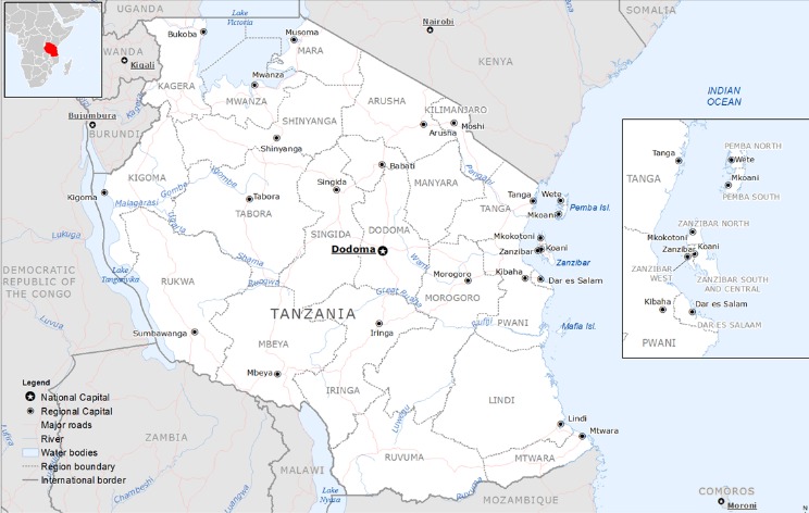
Tanzania is a country located in East Africa, bordered by Kenya and Uganda to the north, Rwanda, Burundi, and the Democratic Republic of the Congo to the west, Zambia, Malawi, and Mozambique to the south, and the Indian Ocean to the east. It shares a coastline along the Indian Ocean, providing it with vital access to maritime routes. Its geographical position places it at the crossroads of central and eastern Africa, making it a significant region for trade, biodiversity, and cultural diversity.
Position on the African Continent
Tanzania is located in East Africa, situated on the eastern coast of the continent along the Indian Ocean. It shares borders with several countries, including Kenya and Uganda to the north, Rwanda, Burundi, and the Democratic Republic of Congo to the west, and Zambia, Malawi, and Mozambique to the south. Its geographical position places it in a strategic area of the African continent, offering diverse landscapes that include savannahs, mountains, and lakes. Tanzania is renowned for its prominent position on the map of Africa, being a key country in the eastern region of the continent.
Bordering Countries
Tanzania is located in East Africa, positioned on the eastern coast along the Indian Ocean. It shares borders with several neighboring countries, making it a key part of the East African region.
- Kenya to the northeast
- Uganda to the northwest
- Rwanda to the west
- Burundi to the southwest
- Democratic Republic of the Congo to the southwest (via Lake Tanganyika)
- Zambia to the south
- Malawi to the south
- Mozambique to the southeast
Coordinates and Latitude-Longitude
Tanzania is a country located in East Africa, known for its diverse landscapes and rich wildlife. Its geographical position places it on the eastern coast of the continent, bordering the Indian Ocean to the east.
- Latitude: approximately between 1° and 11° South
- Longitude: approximately between 30° and 41° East
Physical Features of Tanzania
Tanzania is a country known for its stunning and diverse physical features. From vast plains and expansive savannas to towering mountains and deep lakes, the landscape offers a rich tapestry of natural beauty. The country is home to some of Africa’s most iconic landmarks, including Mount Kilimanjaro, the highest peak on the continent, and Lake Victoria, one of the largest freshwater lakes in the world. These features contribute to Tanzania’s unique geography and vibrant ecosystem.
Main Landforms and Topography
Tanzania is a country characterized by diverse physical features, including vast plains, rugged highlands, and prominent mountain ranges. The mainland features a variety of landforms that contribute to its scenic landscape and rich biodiversity. The country’s topography includes extensive coastal plains along the Indian Ocean, which gradually rise into the inland plateaus. The Great Rift Valley runs through Tanzania from the north to the south, creating a series of depressions and volcanic mountains. Notable highlands include the Maasai Steppe and the Ngorongoro highlands, which are rich in volcanic craters and fertile lands. Mount Kilimanjaro, the highest peak in Africa, dominates the northern landscape and is a major geographical feature of Tanzania. Overall, Tanzania’s physical features are marked by a mix of coastal lowlands, vast plateaus, deep valleys, and towering mountains, making it a country of remarkable topographical diversity on the map.
Mountain Ranges and High Peaks
Tanzania is a country characterized by diverse physical features, including extensive mountain ranges and impressive high peaks that define much of its landscape.
- The Great Rift Valley runs through Tanzania, creating a series of depressions and escarpments that shape much of its terrain.
- Mount Kilimanjaro, the highest peak in Africa, stands at 5,895 meters (19,341 feet) and is a prominent feature on the map of Tanzania.
- Mount Meru, located near Mount Kilimanjaro, reaches 4,566 meters (14,978 feet) and is another significant high peak.
- The Eastern Arc Mountains, a series of ancient hill ranges, stretch across the eastern part of the country, providing lush forests and biodiversity hotspots.
- The Serengeti Plains are situated in the north-central region, characterized by extensive grasslands, although they are not mountainous.
- The Ngorongoro Highlands, part of the volcanic highlands, include extinct crater formations that contribute to the region’s rugged terrain.
Major Lakes and Water Bodies
Tanzania is a country in East Africa characterized by diverse physical features, including expansive plains, highlands, and plateaus. It is known for its spectacular mountain ranges, such as the Eastern Arc Mountains and the Great Rift Valley, which run through the country, creating a varied and scenic landscape.
One of the most prominent physical features of Tanzania is Mount Kilimanjaro, the highest peak in Africa, standing at 5,895 meters above sea level. The country also features the Serengeti Plains, which are vital for wildlife conservation and tourism. Additionally, Tanzania’s terrain includes coastal areas along the Indian Ocean, with some low-lying coastal plains.
Major lakes and water bodies in Tanzania include Lake Victoria, which is the largest lake in Africa and the second-largest freshwater lake in the world. Lake Tanganyika, the second deepest freshwater lake globally, is situated along the western border. Lake Nyasa (or Lake Malawi) forms part of the border with Malawi, while Lake Eyasi and Lake Manyara are smaller lakes found in the central part of the country. The country also has numerous rivers, such as the Rufiji, which flow into these lakes and the Indian Ocean, supporting the diverse ecosystems and agriculture of Tanzania.
National Parks and Forested Areas
Tanzania is a country celebrated for its diverse and stunning physical features, including vast savannahs, highland areas, and extensive coastlines. The country is characterized by the Great Rift Valley running through its eastern part, creating dramatic landscapes and fertile lands. It also boasts Mount Kilimanjaro, Africa’s highest peak, which serves as a prominent geographical landmark. The country’s coastline along the Indian Ocean features beautiful beaches and coral reefs, contributing to its rich biodiversity.
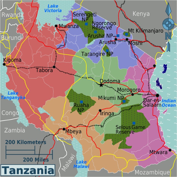
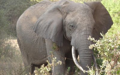
Tanzania is home to numerous national parks and protected forested areas that are renowned for their wildlife and natural beauty. The Serengeti National Park is famous for its annual migration of wildebeests and other herbivores, offering breathtaking views of wildlife in their natural habitat. Ngorongoro Conservation Area, a UNESCO World Heritage Site, hosts a massive volcanic crater teeming with diverse animals. Other notable parks include Tarangire National Park, known for its large elephant populations, and Lake Manyara National Park, which features lush forests and a variety of bird species. Forested areas such as the Udzungwa Mountains and the Usambara Mountains provide critical habitats for unique flora and fauna, making Tanzania a paradise for nature lovers and conservationists alike.
Political Boundaries and Administrative Divisions
Political boundaries and administrative divisions play a crucial role in shaping the organization and governance of a country. They define the borders between different regions, provinces, or districts, facilitating effective administration and resource management. In the context of Tanzania, understanding these divisions is essential to grasp the country’s geographical and political landscape, which influences its development and regional interactions.
Regions and Districts
Tanzania is a country in East Africa that is divided into several political boundaries and administrative divisions, including regions and districts. These divisions help in governance, administration, and regional development, ensuring that resources and services are distributed effectively across the country.
- Regions: Tanzania is divided into 31 regions, each functioning as a major administrative unit. Some of the key regions include Dar es Salaam, Arusha, Dodoma, and Mwanza.
- Districts: Each region is further subdivided into districts, which serve as local government areas responsible for implementing policies and managing local affairs. There are over 170 districts across the country.
- Boundary Markings: Tanzania’s political boundaries are defined by natural features like lakes and rivers, as well as colonial borders that have been maintained since independence. These boundaries are marked on maps and used for electoral and administrative purposes.
- Regional Capitals: Each region has a capital city or town that serves as its administrative hub, facilitating regional governance and coordination.
- Local Governance: The districts are managed by district councils, which oversee local development projects, public services, and community welfare within their jurisdiction.
Capital City and Major Urban Areas
Tanzania is a country located in East Africa, distinguished by its diverse political boundaries and administrative divisions. It is divided into several regions, each governed by local authorities to manage regional development and services efficiently. The country’s political map highlights these divisions, illustrating the nation’s internal administrative structure.
The capital city of Tanzania is Dodoma, designated as the political and administrative center of the country. While Dar es Salaam remains the largest city and economic hub, Dodoma hosts the government offices and parliament, symbolizing Tanzania’s political identity.
Major urban areas in Tanzania include Dar es Salaam, Arusha, Mwanza, and Mbeya. Dar es Salaam is the largest metropolis, known for its vibrant markets, ports, and industrial zones. Arusha serves as a gateway to safaris and regional diplomacy, while Mwanza and Mbeya are important centers for commerce and culture within the country.
Key Landmarks and Natural Attractions
Tanzania is a country renowned for its stunning landmarks and breathtaking natural attractions that draw visitors from around the world. From majestic mountains to vibrant wildlife parks, this nation offers a diverse array of scenic wonders. Exploring Tanzania on the map reveals iconic sites such as Mount Kilimanjaro, the Serengeti plains, and the Ngorongoro Crater, each representing the country’s rich natural beauty and cultural heritage.
Mount Kilimanjaro
Mount Kilimanjaro is one of the most iconic natural landmarks in Tanzania and a major attraction for travelers. It is the highest peak in Africa and the tallest free-standing mountain in the world, standing at 19,341 feet above sea level. The mountain is part of Kilimanjaro National Park, which is a UNESCO World Heritage Site, and offers a challenging yet rewarding climb for trekking enthusiasts from around the globe.
Serengeti National Park
Serengeti National Park is one of Tanzania’s most renowned landmarks, famous for its vast plains and incredible wildlife migrations. This UNESCO World Heritage Site spans over 14,750 square kilometers and is home to the iconic Great Migration, where millions of wildebeests, zebras, and other animals traverse the plains in search of fresh grazing areas. The park also features striking natural attractions such as the Seronera River and the Kopjes—granite rock formations that provide vital habitat for predators and unique scenery for visitors. Visitors to Serengeti can witness an abundance of wildlife, including lions, elephants, cheetahs, and giraffes, making it a top destination for safaris and nature enthusiasts exploring Tanzania on the map.
Ngorongoro Crater
The Ngorongoro Crater is one of Tanzania’s most renowned natural attractions and a key landmark on the map of the country. This UNESCO World Heritage Site is a massive volcanic caldera that measures about 20 kilometers across, housing a diverse range of wildlife and stunning landscapes. The crater is often called the “Garden of Eden” due to its abundant flora and fauna, including lions, elephants, rhinoceroses, and countless bird species. Visitors to Tanzania flock to this natural wonder for game drives, photography, and experiencing the unique ecosystem that has been preserved within the crater’s walls. Alongside other landmarks like Mount Kilimanjaro and the Serengeti Plains, the Ngorongoro Crater exemplifies Tanzania’s rich natural heritage and scenic beauty.
Lake Victoria and Lake Tanganyika
Tanzania is renowned for its stunning natural landscapes and iconic water bodies, making it a prime destination for travelers interested in key landmarks and natural attractions.
- Lake Victoria: The largest lake in Africa and one of the biggest tropical freshwater lakes in the world, Lake Victoria is shared by Tanzania, Uganda, and Kenya. It is vital for local fishing communities and offers beautiful scenery and diverse wildlife.
- Lake Tanganyika: Known as the second deepest freshwater lake globally, Lake Tanganyika is situated along the western border of Tanzania. It is famed for its clear waters, unique aquatic species, and opportunities for fishing and boat trips.
Map Features and Symbols
Understanding map features and symbols is essential for interpreting maps accurately. When studying Tanzania on a map, various symbols represent important landmarks, roads, rivers, and other geographical features. These symbols help users quickly identify and understand the diverse terrain and significant locations across the country, making navigation and learning about Tanzania’s geography easier and more efficient.
Legend Explanation
Map features and symbols on a map of Tanzania help users identify key locations and landmarks easily. Symbols such as rivers, lakes, mountains, and cities are represented by different icons and shapes to provide clear visuals. The legend explains what each symbol stands for, ensuring that users can interpret the map accurately. For example, a blue line may indicate a river, while a green area could represent national parks or forests. Understanding these symbols allows travelers and researchers to navigate and study the region effectively, making the map a valuable tool for exploration and planning.
Elevation and Terrain Indicators
On a map of Tanzania, various features and symbols help users understand the geographic landscape. Elevation is represented through contour lines or color gradients, indicating the height above sea level, with higher elevations often shown in darker shades. Terrain indicators highlight different landforms such as mountains, valleys, and plains; for example, the Great Rift Valley is marked by distinct terrain symbols. Standard symbols are used to denote significant features like national parks, rivers, roads, and cities, making navigation easier. These symbols are universally recognized, ensuring clarity for both locals and travelers exploring Tanzania’s diverse terrains.
Transportation Networks on Map
In maps of Tanzania, various features and symbols are used to represent different elements such as roads, railways, airports, and geographical landmarks. Transportation networks are crucial for understanding connectivity within the country. Major roads are depicted with solid lines, often in different colors to indicate types, such as highways or secondary roads. Railways are typically shown with dashed lines or specific symbols to differentiate them from roads. Airports are marked with airplane symbols, highlighting key points for air travel. Other map symbols include symbols for ports, bus stations, and ferry routes, which help travelers navigate the country’s transportation options. These features collectively provide a clear visual representation of Tanzania’s transportation infrastructure, facilitating easier planning and navigation across the country.

0 Comments