
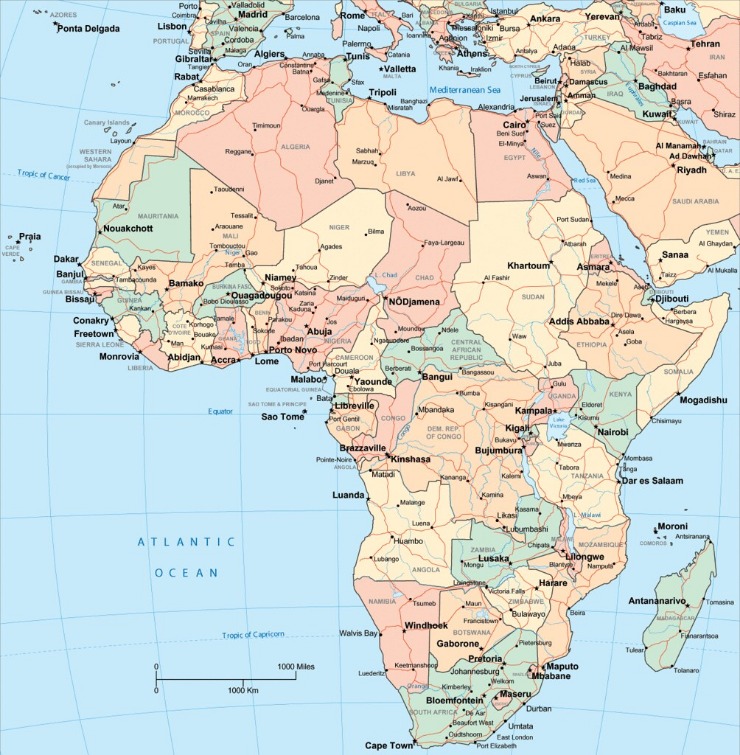
Geographical Overview of Tanzania
Tanzania, located in East Africa, is renowned for its diverse landscapes and rich natural resources. Covering an area of approximately 945,747 square kilometers, it features expansive savannahs, highlands, and coastal regions along the Indian Ocean. The country’s geographical features include iconic landmarks such as Mount Kilimanjaro, Africa’s tallest mountain, and the Great Rift Valley. Tanzania’s strategic location and varied terrain make it a significant region on the map of Africa, supporting vibrant ecosystems and a range of cultural histories.
Location and Coordinates
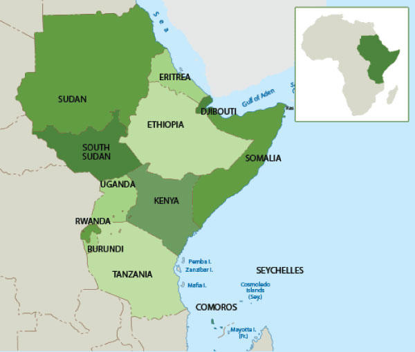
Tanzania is a country located in East Africa, known for its diverse landscapes and rich cultural heritage. It is bordered by Kenya and Uganda to the north, Rwanda, Burundi, and the Democratic Republic of Congo to the west, and Zambia, Malawi, and Mozambique to the south. The Indian Ocean lies to the east of Tanzania, providing it with a significant coastline. The country’s geographical diversity includes savannahs, mountains, lakes, and coastal plains.
The geographical coordinates of Tanzania are approximately 6° and 12° South latitude, and 29° and 40° East longitude. The country features notable features such as Mount Kilimanjaro, the highest peak in Africa, and Lake Victoria, one of the largest freshwater lakes in the world. Its strategic location on the map of Africa makes Tanzania an important country in the region, with prominent landmarks and national parks that attract tourists from around the globe.
Borders and Neighboring Countries
Tanzania is a country located in East Africa, known for its diverse landscapes and rich cultural heritage. It is bordered by several countries, making it a significant part of the African continent. The country is situated along the eastern coast of Africa, with a coastline along the Indian Ocean. To the north, Tanzania shares borders with Kenya and Uganda, while to the west, it borders Rwanda, Burundi, and the Democratic Republic of the Congo. Southward, it is bordered by Malawi and Mozambique, and to the southeast, it shares a border with Zambia. The geographical position of Tanzania makes it a central hub in the region, with the famous Mount Kilimanjaro and Serengeti National Park situated within its borders. The country’s map highlights its extensive land area, including major lakes such as Lake Victoria, Lake Tanganyika, and Lake Malawi. Overall, Tanzania’s borders and neighboring countries shape its strategic importance and cultural diversity within the African continent.
Total Area and Geographic Features
Tanzania is a country located in East Africa, known for its diverse geographical features and vast landscapes. Covering a total area of approximately 945,087 square kilometers, it is one of the largest countries in Africa. The nation features a variety of geographic elements, including coastal plains along the Indian Ocean, extensive savannas, and highland areas such as the Serengeti Plateau. Tanzania is also home to several prominent lakes, notably Lake Victoria, Lake Tanganyika, and Lake Nyasa, which significantly influence the region’s climate and ecosystems. The country’s diverse terrain includes mountains, such as Mount Kilimanjaro, Africa’s highest peak, and numerous national parks and reserves that host rich wildlife and natural beauty, making Tanzania a fascinating destination within the African continent as seen on a Tanzania map of Africa.
Main Regions and Administrative Divisions
Tanzania, a vibrant country located in East Africa, is known for its diverse landscapes and rich cultural heritage. Its main regions and administrative divisions play a crucial role in its governance and development, helping to organize its vast territory into manageable areas. Understanding these divisions provides better insight into the country’s geographical layout and regional characteristics, which are essential when exploring a map of Tanzania in Africa.
Regions of Tanzania
Tanzania is a large country located in East Africa, distinguished by its diverse geographical features and cultural regions. It is divided into several main regions, each with its own administrative divisions that help manage local governance and development. The country has a total of 31 regions, which are further subdivided into districts and wards, facilitating efficient administration and resource allocation.
Some of the prominent regions of Tanzania include Dar es Salaam, Arusha, Mwanza, Dodoma, and Zanzibar. Dar es Salaam serves as the economic hub, while Dodoma is the political capital. Zanzibar, an autonomous region, comprises the Zanzibar Archipelago and is known for its unique cultural heritage. These regions vary greatly in terms of population, geography, and economic activities, reflecting Tanzania’s rich diversity.
Overall, Tanzania’s regional divisions provide a framework for local governance, development projects, and cultural identity, making it a fascinating country with a complex administrative structure within the broader context of an Africa map.
Major Districts and Municipalities
Tanzania is a country located in East Africa, known for its diverse regions and administrative divisions. The country is divided into main regions, each with its own unique cultural and geographical characteristics. These regions are further subdivided into districts and municipalities, serving as administrative units for governance and local administration. Major districts include Dar es Salaam, Arusha, Dodoma, and Mwanza, which are key economic and political centers. Municipalities like Dodoma and Zanzibar City play significant roles in representing the administrative and urban hubs within the country. Overall, Tanzania’s administrative framework facilitates effective governance across its vast and varied landscape.
Autonomous and Special Zones
Tanzania is divided into several main regions and administrative divisions, each serving specific local governance functions. These regions are further subdivided into districts, councils, and wards to facilitate administrative management and development planning. Additionally, Tanzania has autonomous and special zones designated for particular purposes, such as the Zanzibar Archipelago, which operates semi-autonomously under the framework of the Union of Tanzania. These zones and divisions enable the country to manage its diverse geographical, cultural, and political landscape effectively, ensuring local representation and administrative efficiency across the nation. The map of Tanzania in Africa highlights these regions and zones, providing a clear view of its administrative structure.
Major Landforms and Natural Features
Tanzania, located in East Africa, is renowned for its diverse and stunning landforms. From vast plains and towering mountains to extensive lakes and lush forests, the country’s natural features create a unique landscape. These major landforms not only shape Tanzania’s geography but also contribute to its rich biodiversity and cultural heritage, making it a fascinating destination for explorers and nature enthusiasts alike.
Mount Kilimanjaro
Mount Kilimanjaro, located in Tanzania, is Africa’s highest peak and a prominent feature on the Tanzania map of Africa. It is a majestic dormant volcano comprising three cones: Kibo, Mawenzi, and Shira. The mountain stands approximately 5,895 meters (19,341 feet) above sea level, making it the tallest free-standing mountain in the world. Its summit, Uhuru Peak, attracts many trekking enthusiasts from around the globe who seek to experience the challenging climb and breathtaking views.
As a major landform in Tanzania, Mount Kilimanjaro significantly influences the surrounding landscape, including lush rainforests on its lower slopes, alpine meadows, and arid deserts at its base. The mountain’s diverse ecosystems support a wide variety of flora and fauna, and the snow-capped summit is a symbol of natural beauty and environmental significance in the region. Kilimanjaro’s prominence on the Africa map highlights its importance as a natural wonder and a key feature of Tanzania’s geography.
Great Rift Valley
The Great Rift Valley is one of the most prominent landforms featured on the map of Tanzania in Africa. It stretches from the Red Sea down through Eastern Africa, creating a series of deep trenches and valleys. This major geological feature is characterized by its dramatic escarpments, lakes, and volcanic activity. The Rift Valley has significantly influenced Tanzania’s landscape, contributing to the formation of famous lakes such as Lake Victoria, Lake Tanganyika, and Lake Malawi. These freshwaters support diverse ecosystems and are vital for local agriculture and communities. The valley also hosts several national parks and reserves, making it a key area for wildlife conservation and tourism. Overall, the Great Rift Valley is a defining natural feature that shapes the terrain and biodiversity of Tanzania in Africa.
Serengeti Plains
The Serengeti Plains are one of the most renowned natural features in Tanzania, located in the northern part of the country. These vast grasslands are part of the larger Serengeti ecosystem, famous for their incredible biodiversity and the iconic migration of wildebeest and other herbivores. The plains provide a critical habitat for numerous species and are a major highlight on the Tanzania map in Africa.
- Extensive grasslands spanning approximately 14,750 square kilometers.
- Home to a wide variety of wildlife including lions, elephants, zebras, and cheetahs.
- Known for the Serengeti’s annual migration, which is one of the most spectacular wildlife events in the world.
- Surrounded by other major landforms such as the Ngorongoro Crater and the East African Rift Valley.
- An essential part of Tanzania’s national parks and game reserves, contributing significantly to eco-tourism.
Lake Victoria and Other Lakes
Tanzania is renowned for its diverse major landforms and natural features, which include vast savannas, highlands, and numerous lakes. Among these, Lake Victoria stands out as the largest lake in Africa and the second-largest freshwater lake in the world, forming part of the Great Rift Valley. It spans across Tanzania, Uganda, and Kenya, playing a crucial role in the region’s ecosystem and economy. Alongside Lake Victoria, Tanzania is home to other significant lakes such as Lake Tanganyika and Lake Nyasa (Malawi), each offering unique ecological habitats and contributing to local livelihoods. The country’s landscape is characterized by the Serengeti plains, the Ngorongoro Crater, Mount Kilimanjaro—the tallest peak in Africa—and the picturesque coastline along the Indian Ocean. These natural features not only shape Tanzania’s geography but also support rich biodiversity and promote tourism and agriculture across the nation.
Significant Bodies of Water
Significant bodies of water play a vital role in shaping the geography and ecosystems of Tanzania, a country located in East Africa. These waters, including lakes, rivers, and the Indian Ocean coastline, support diverse wildlife, provide resources for communities, and influence the climate of the region. Understanding these bodies of water is essential for appreciating Tanzania’s natural landscape and its importance within the map of Africa.
Indian Ocean Coastline
The Indian Ocean coastline of Tanzania is a prominent feature of the country’s geography, offering extensive access to one of the world’s largest bodies of water. This coastline stretches along the eastern edge of Tanzania, providing vital routes for trade, travel, and tourism. The area is home to some of Africa’s most famous beaches, islands, and marine ecosystems, making it an essential part of the nation’s natural landscape and economic development.
- Dar es Salaam: The largest city and commercial hub located along the Indian Ocean, serving as Tanzania’s main port.
- Zanzibar Archipelago: A group of islands renowned for their beautiful beaches, historical sites, and vibrant culture.
- Pemba Island: Known for its lush landscapes and coral reefs, vital for fishing and tourism industries.
- Ruins of Kilwa Kisiwani: An ancient medieval trading city with historical significance along the coast.
- Marine Protected Areas: Including the Mafia Island Marine Park, which supports marine biodiversity and eco-tourism.
Inland Lakes and Rivers
Tanzania is a country in East Africa renowned for its diverse and significant bodies of water. The country is bordered by the Indian Ocean to the east, which features a long coastline with beautiful beaches and important ports. Inland, Tanzania is home to numerous lakes, with Lake Victoria being the largest, shared with Uganda and Kenya. Lake Tanganyika and Lake Nyasa (Malawi) are also prominent and among the deepest freshwater lakes in the world. These lakes are vital for transportation, fishing, and local economies. Rivers such as the Rufiji River and the Pangani River play crucial roles in agriculture, hydroelectric power, and sustaining the region’s ecosystems. Overall, Tanzania’s lakes and rivers are integral to its geography, economy, and environment, shaping its landscape and supporting its population.
Water Resources and Usage
Tanzania, located in East Africa, is renowned for its rich and diverse water resources, which play a vital role in the country’s ecology, economy, and daily life. Major bodies of water in Tanzania include Lake Victoria, the largest freshwater lake in Africa and the second-largest in the world, along with Lake Tanganyika and Lake Nyasa (Malawi). These lakes are essential sources of water for domestic, agricultural, and industrial use, supporting millions of people and various ecosystems.
Besides lakes, Tanzania is endowed with numerous rivers such as the Rufiji, Ruvuma, and Pangani, which provide freshwater for irrigation, hydroelectric power generation, and other needs. The Rufiji River, in particular, is crucial for hydroelectric projects like the Stiegler’s Gorge Dam, which aims to increase the country’s electricity capacity.
Water resources in Tanzania face challenges including pollution, over-extraction, and inconsistent rainfall due to climate change. These issues threaten water availability and quality, impacting both human populations and wildlife. Sustainable water management practices and investments in infrastructure are necessary to ensure the long-term availability and equitable distribution of water resources across the country.
Map Features and Land Use
Understanding map features and land use is essential for interpreting geographic information, especially when exploring regions like Tanzania in Africa. Maps provide detailed visuals of an area’s physical characteristics, infrastructure, and land utilization, helping users navigate and analyze the land efficiently. In Tanzania, a diverse country with rich natural resources and varied landscapes, map features and land use patterns reveal important insights into how the land is cultivated, developed, and preserved for different purposes.
Protected Areas and National Parks
Tanzania map of Africa showcases a diverse range of land features, land use patterns, protected areas, and national parks that highlight the country’s rich natural heritage and environmental significance.
- Map Features and Land Use:
- The map displays varied features such as mountains, savannahs, lakes, and coastal areas, illustrating Tanzania’s diverse landscape.
- Land use on the map indicates areas designated for agriculture, urban development, and pastoral activities, reflecting the country’s economic activities.
- Topographical details such as the presence of the Great Rift Valley and Mount Kilimanjaro are prominently marked, giving insight into the terrain.
- Protected Areas and National Parks:
- Major protected areas include Serengeti National Park, known for its wildebeest migrations, and Ngorongoro Conservation Area, a UNESCO World Heritage site.
- Other significant parks like Tarangire, Lake Manyara, and Ruaha serve as critical habitats for diverse wildlife species.
- The map highlights boundaries of national parks and reserves, emphasizing Tanzania’s commitment to conservation and ecotourism.
Urban and Rural Land Distribution
Tanzania’s map features and land use illustrate a diverse landscape that encompasses urban centers, rural areas, and vast natural environments. The country is characterized by a mixture of developed cities, agricultural land, forests, and protected wildlife reserves. Urban areas such as Dar es Salaam and Arusha serve as economic and cultural hubs, while the majority of land remains rural, supporting farming and livestock activities. Land use planning in Tanzania emphasizes balancing development with conservation, ensuring sustainable use of natural resources. The distribution of land in Tanzania shows a pattern of dense urban settlements along the coast and inland urban centers, while rural land stretches extensively across the hinterlands, highlighting the importance of agriculture and community-based settlements across the country.
Agricultural and Industrial Zones
Tanzania map of Africa showcases various land use features that highlight the country’s diverse landscape. Agricultural zones are prominently marked, reflecting Tanzania’s reliance on farming and related activities. These areas are typically located in the fertile plains and more temperate regions, supporting crops such as maize, coffee, and tea. Industrial zones are also identified, often situated near urban centers like Dar es Salaam and Arusha, where manufacturing, processing, and other industries thrive. The map provides a clear distinction between these zones, facilitating better understanding of the country’s spatial development and resource allocation.
Navigation and Transportation Network
Navigation and transportation networks are essential components that facilitate movement and connectivity within a country and across regions. In Tanzania, a country located in East Africa, these networks play a vital role in supporting economic growth, enabling trade, and improving access to remote areas. Understanding the layout of Tanzania’s transportation infrastructure helps to appreciate its strategic position on the African map and its efforts to enhance mobility for both people and goods.
Road and Rail Infrastructure
Navigation and transportation networks in Tanzania are vital for connecting its diverse regions and facilitating economic growth. The country boasts a well-developed road and rail infrastructure that supports both domestic and international trade. Major highways link urban centers like Dar es Salaam, Arusha, and Dodoma, ensuring efficient road transportation across the mainland. The rail network, operated primarily by Tanzania Railways Corporation, connects key cities to ports such as Dar es Salaam, enabling the movement of goods to global markets. Additionally, Tanzania’s strategic location along the Indian Ocean allows for maritime navigation, with ports serving as important hubs for regional commerce. Overall, the integrated transportation infrastructure plays a crucial role in fostering development and integrating Tanzania into the broader African economy.
Airports and Seaports
Tanzania’s extensive navigation and transportation network plays a vital role in connecting various regions within the country and facilitating international trade. The country boasts a well-developed network of roads, railways, airports, and seaports that are crucial for economic growth and mobility. Major airports such as Julius Nyerere International Airport in Dar es Salaam and Kilimanjaro International Airport serve as key gateways for travelers and cargo, linking Tanzania to global destinations. Additionally, the seaports of Dar es Salaam, Tanga, and Mtwara are essential for maritime trade, handling a significant volume of imports and exports. These transportation hubs support commerce, tourism, and the movement of goods across Africa, contributing significantly to Tanzania’s strategic position on the map of Africa.
Connectivity and Accessibility
Navigation and transportation networks in Tanzania are vital for connecting urban centers, rural areas, and neighboring countries, thereby facilitating economic growth and regional integration. The country’s transportation system includes roads, railways, ports, and airports, which together enhance connectivity and accessibility across the region. Major highways link Dar es Salaam, Arusha, and Mwanza, supporting both domestic and international trade. The strategic location of ports like the Dar es Salaam port serves as a key gateway for imports and exports, boosting Tanzania’s role in maritime trade on the African continent. Rail networks, although expanding, are essential for freight movement, integrating inland areas with coastal ports. Accessibility within Tanzania varies, with urban centers enjoying better infrastructure, while remote regions face challenges that require ongoing development efforts. Overall, Tanzania’s transportation network plays a crucial role in fostering regional connectivity on the African map, promoting economic development and shared prosperity.
Tourist Attractions Mapped
Tanzania, located in East Africa, is renowned for its stunning landscapes and diverse attractions. A comprehensive map of Tanzania in Africa highlights the country’s most popular tourist destinations, from the iconic Serengeti National Park to the majestic Mount Kilimanjaro. Exploring these mapped attractions provides travelers with a visual guide to the natural beauty and cultural treasures that make Tanzania a must-visit destination in Africa.
Wildlife Reserves and Safari Routes
The Tanzania map of Africa highlights some of the most renowned tourist attractions, wildlife reserves, and safari routes that make the country a premier destination for nature lovers and adventure seekers. Visitors can explore a diverse range of ecosystems, from lush savannahs to rugged mountains, and experience unforgettable wildlife encounters.
- Serengeti National Park: Famous for the annual wildebeest migration and abundant wildlife viewing opportunities.
- Ngorongoro Conservation Area: Known for the Ngorongoro Crater, a UNESCO World Heritage site with a dense population of wildlife.
- Tarangire National Park: Noted for its large elephant herds and unique baobab trees.
- Lake Manyara National Park: Offers birdwatching and the chance to see tree-climbing lions.
- Selous Game Reserve: One of Africa’s largest wildlife reserves, ideal for boat safaris and varied fauna.
- Southern Serengeti Safari Route: A popular route for witnessing the migration and big game viewing.
- Central Rift Valley Route: Connects major parks and reserves, offering diverse landscapes and animals.
- Northern Circuit: Includes visits to Arusha, Serengeti, Ngorongoro, and Lake Manyara, forming a comprehensive safari experience.
- Western Tanzania Wildlife Corridor: Provides access to remote reserves like Gombe Stream and Mahale Mountains, known for chimpanzee trekking.
Overall, the Tanzania map features a well-organized network of tourist attractions, wildlife reserves, and safari routes that showcase the country’s rich biodiversity and natural beauty, making it an ideal destination for eco-tourism and adventure travel.
Historical and Cultural Sites
Explore the diverse tourist attractions and historical sites across Tanzania with our detailed map of Africa. Tanzania is renowned for its rich cultural heritage and stunning natural scenery, making it a perfect destination for travelers interested in history and culture. Visitors can discover iconic landmarks such as the Serengeti National Park, Ngorongoro Crater, and Mount Kilimanjaro, each offering unique insights into the region’s history and wildlife. Historical sites like the Olduvai Gorge, known as the “Cradle of Mankind,” provide valuable archaeological insights. Additionally, locations such as Stone Town in Zanzibar showcase intricate architecture and tell stories of the island’s storied past as a trading hub. Our Tanzania map highlights these key cultural and historical sites, making it easier for travelers to plan their visits and immerse themselves in the country’s fascinating history and vibrant culture.
Beaches and Coastal Resorts
Tanzania, located in East Africa, boasts a diverse array of tourist attractions, with its beaches and coastal resorts drawing visitors from around the world. The country’s coastline along the Indian Ocean features pristine beaches, vibrant coral reefs, and luxurious resorts that offer relaxation and adventure alike. Notable coastal destinations include Zanzibar, renowned for its white sandy beaches, historic Stone Town, and vibrant cultural scene. The map of Tanzania highlights these attractions, making it easier for travelers to plan visits to key seaside locations. From the stunning beaches of Paje to the serene shores of Kendwa, coastal resorts in Tanzania provide an ideal escape for sunbathers, snorkelers, and explorers seeking the tranquility of the Indian Ocean. Exploring these mapped locations allows tourists to experience Tanzania’s natural beauty and diverse marine life in a truly unforgettable setting.
Political and Cultural Regions
Political and cultural regions in Tanzania play a vital role in shaping the country’s identity and social dynamics. These regions reflect a diverse mix of ethnic groups, traditions, and historical backgrounds that contribute to Tanzania’s rich national tapestry. Understanding these divisions provides insight into the political landscape and cultural heritage across different parts of the country, especially within the context of the Tanzania map of Africa.
Ethnic and Cultural Distribution
Tanzania, located in East Africa, is a country characterized by diverse political and cultural regions, reflecting its rich ethnic mosaic and historical influences. The nation is divided into several administrative regions, each with unique cultural identities and local governance structures. These regions are often influenced by the geographic landscape, such as the coastal areas, inland plains, and highland zones, shaping regional identities.
Ethnically, Tanzania is home to over 120 different ethnic groups, with the largest being the Sukuma, Chaga, Haya, Nyamwezi, and Makonde. The Swahili are the dominant ethnic group along the coast, contributing to the widespread use of Swahili as the national language, uniting diverse communities. Many ethnic groups have their own distinctive languages, traditions, and customs, which contribute to the nation’s cultural richness.
In terms of cultural distribution, coastal areas tend to have a blend of African and Arab influences, especially in urban centers like Dar es Salaam and Zanzibar. The inland regions largely maintain traditional practices, including music, dance, and art forms specific to their ethnic groups. Religious practices are predominantly Christianity and Islam, with indigenous beliefs also prevalent in certain regions, impacting cultural expressions and social organization.
Overall, Tanzania’s political and cultural landscape is a complex tapestry woven through its ethnic diversity, regional distinctions, and historical interactions, making it a unique mosaic within the African continent and a fascinating subject on the map of Africa.
Major Cities and Capitals
Tanzania, located in East Africa, is a country rich in diverse political and cultural regions. It comprises numerous ethnic groups and cultural areas, each contributing to the nation’s vibrant identity. Major cities such as Dar es Salaam, the largest city and economic hub, and Dodoma, the political capital where the government is centered, are key urban centers. Other significant cities include Arusha, known for its tourism industry and proximity to national parks, and Mwanza, an important port city on Lake Victoria. Dodoma serves as the official capital, hosting government offices and the national parliament. The country’s regions reflect a blend of traditional cultures and modern influences, making Tanzania a prominent example of cultural diversity within the African continent. Understanding these regions and cities offers insights into Tanzania’s political landscape and cultural fabric.
Local Languages and Cultural Practices
Tanzania, situated in East Africa, is a country rich in political and cultural diversity. Its political regions are divided into multiple administrative zones, each with its own local governance structures that reflect the country’s complex history and ethnic composition. The cultural landscape of Tanzania is equally diverse, with numerous ethnic groups, traditions, and practices that shape its national identity.
Local languages in Tanzania are as varied as its ethnic groups. Swahili and English are the official languages, used in government and education, but there are over 120 indigenous languages spoken throughout the country. These languages are integral to the cultural practices of different communities, preserving traditional stories, rituals, and social norms.
Cultural practices in Tanzania are deeply rooted in its history and ethnic diversity. Traditional dance, music, and festivals are common and vary from region to region. For example, the Maasai are renowned for their vibrant ceremonies and beadwork, while coastal communities celebrate unique fishing and trading traditions. These cultural elements are vital in maintaining the social fabric and identity of Tanzania’s diverse population.



0 Comments