.jpeg")
Overview of Algeria’s Land Area
Algeria, the largest country in Africa, boasts a diverse and expansive land area that spans various landscapes and geographical features. Covering approximately 2.38 million square kilometers, its territory includes deserts, mountains, and fertile plains, making it a significant nation in terms of size and natural diversity. Understanding Algeria’s land area provides valuable insights into its physical geography and the distribution of its natural resources.
Total Land Area
Algeria is the largest country in Africa by land area, covering a vast expanse of the northern part of the continent. Its total land area is approximately 2.38 million square kilometers, making it the tenth-largest country in the world. The country’s extensive geography includes a diverse range of landscapes, from the sweeping Sahara Desert in the south to the fertile plains and mountainous regions in the north. Algeria’s vast land area plays a significant role in its climate, biodiversity, and economic activities such as agriculture and natural resource extraction.
Comparison with Other African Countries
Algeria is the largest country in Africa by land area, covering approximately 2.38 million square kilometers. Its vast expanse makes it a prominent geographical feature on the continent. When compared to other African nations, Algeria’s land area surpasses that of most countries, including Nigeria, which is the most populous but much smaller in size. For instance, Nigeria has about 923,768 square kilometers, significantly less than Algeria. South Africa, another large country, has roughly 1.22 million square kilometers, still considerably smaller than Algeria. Egypt and the Democratic Republic of the Congo also have extensive land areas, but both fall short of Algeria’s size. This enormous land mass gives Algeria a diverse range of climates, terrains, and natural resources, positioning it as a key territorial nation in Africa. Its size also influences its economic potential, agricultural capacity, and strategic importance on the continent.
Geographical Boundaries
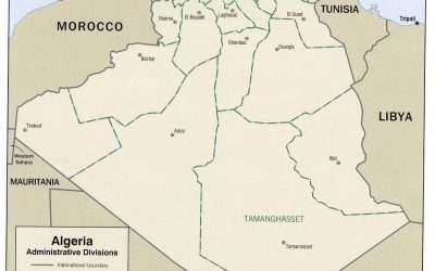
Algeria is the largest country in Africa by land area, covering approximately 2.38 million square kilometers. Its vast territory features diverse landscapes, including deserts, mountains, and plains. The country’s geographical boundaries are defined by its neighboring nations and natural borders. To the north, Algeria is bordered by the Mediterranean Sea, providing a coastline that extends around 1,200 kilometers. It shares land borders with Tunisia and Libya to the northeast, Niger to the southeast, Mali and Mauritania to the southwest, Western Sahara to the west, and Morocco to the northwest. These boundaries give Algeria a strategic position in North Africa, with a landscape that ranges from the vast Sahara Desert in the south to the Tell Atlas mountain range and coastal plains in the north.
Geographical Features and Terrain
Algeria’s land area is characterized by a diverse range of geographical features and terrain that shape its landscape. From vast deserts to fertile coastal plains, the country’s terrain offers a remarkable variety of natural formations. Understanding these geographical features provides insight into Algeria’s physical landscape and how it influences the climate, biodiversity, and human settlement patterns across the nation.
Desert Regions
Algeria’s land area encompasses a diverse array of geographical features and terrain, with significant portions dominated by vast desert regions. The Sahara Desert extends across much of southern Algeria, creating an arid, expansive landscape characterized by sand dunes, rocky plateaus, and rare pockets of vegetation. This desert region is marked by immense sandy plains known as erg, as well as rocky plateaus called hamadas, which are often precipitous and inhospitable. In the northern part of the country, the terrain transitions to the Tell Atlas mountain range, featuring rugged mountains, fertile plains, and river valleys. The contrasting terrains contribute to Algeria’s diverse climate, with the desert region experiencing extreme heat and low rainfall, while the coastal areas enjoy a Mediterranean climate. Overall, Algeria’s land area is defined by its remarkable desert expanses, rugged mountains, and fertile coastal plains that together shape its distinctive geographical identity.
Sandy Plains and Sand Dunes
Algeria’s land area is characterized by diverse geographical features that shape its landscape. Among these features, sandy plains and sand dunes are prominent, especially in the Sahara Desert region. The sandy plains are expansive, flat areas covered with fine sands, offering a stark contrast to the more rugged mountainous regions. These plains often serve as the base for large sand dunes, which are some of the most iconic natural features in Algeria. Sand dunes in Algeria can reach impressive heights and are shaped by the prevailing winds, creating constantly shifting landscapes that are both beautiful and challenging. These features are vital to understanding the country’s geography, as they influence climate, vegetation, and human activity across Algeria’s vast territory.
Mountain Ranges and Highlands
Algeria’s landscape is characterized by diverse geographical features that shape its vast land area. The country’s terrain includes expansive deserts, mountain ranges, highlands, and fertile plains, creating a varied topography. One of the most prominent features is the Atlas Mountain range, which stretches across northern Algeria and forms a natural barrier between the coast and the Sahara desert. The Tell Atlas runs parallel to the Mediterranean coastline, featuring rugged mountains and lush valleys, while the Saharan Atlas lies further south, blending into the vast Sahara Desert. The highlands in the northeast, including the Kabylie region, showcase elevated terrains with hills and volcanic formations. Overall, Algeria’s mountain ranges and highlands contribute significantly to its geographical diversity, influencing climate, vegetation, and settlement patterns across the country.
Coastal Plains
Algeria’s land area is characterized by diverse geographical features and terrains, with a prominent coastal plain that greatly influences its landscape and climate. The coastal plains along the Mediterranean Sea form an essential part of the country’s geography, providing fertile land for agriculture and urban development.
- The coastal plains in Algeria extend from the northern border with Tunisia to the western regions near Morocco. These areas are relatively flat and fertile, making them suitable for farming and supporting major cities like Algiers, Oran, and Annaba.
- Within these plains, the terrain transitions gradually from the sea to inland mountainous regions, such as the Tell Atlas, which lie just south of the coastal plain.
- The coastal plain features a Mediterranean climate, with mild, wet winters and hot, dry summers, fostering a thriving agricultural sector.
- The terrain then ascends to the rugged mountains and the Sahara Desert in the south, illustrating the vast diversity of Algeria’s landscape across its land area.
Regional Distribution of Land Area
Algeria, the largest country in Africa, boasts diverse land regions that vary significantly in size and geographical features. Understanding the regional distribution of land area within Algeria provides insight into its physical landscape, climate zones, and territorial organization. This overview highlights the main geographical regions that collectively define Algeria’s vast and varied terrain.
Northern Algeria
Northern Algeria encompasses a diverse range of landscapes and land uses, with a significant portion of the country’s total land area. The region is characterized by fertile plains, mountainous areas, and coastal zones, which together contribute to its varied land distribution. The coastal plain along the Mediterranean Sea is densely populated and extensively cultivated, serving as the agricultural and economic hub of the region. To the interior, the Tell Atlas mountains dominate the landscape, covering a substantial part of Northern Algeria and featuring rugged terrain and limited arable land. The steep terrain and rocky surfaces in these mountainous areas reduce the overall agricultural potential, leading to a varied distribution of land use. The coastal and plains areas collectively account for a significant percentage of Algeria’s total land area, emphasizing the importance of Northern Algeria in national land resources and development. Overall, Northern Algeria’s land area distribution reflects the region’s complex topography and its vital role in the nation’s economy and settlement patterns.
Central Highlands
The Central Highlands of Algeria encompass a significant portion of the country’s land area, characterized by mountainous terrain and diverse landscapes. This region is primarily situated between the Tell Atlas to the north and the Sahara Desert to the south, covering parts of several provinces. The land distribution in the Central Highlands varies, with some areas densely covered with forests and fertile valleys, while others are more arid and rugged. These land areas are crucial for agriculture, livestock herding, and local livelihoods, contributing substantially to Algeria’s overall land use. The region’s diverse topography influences settlement patterns and economic activities, making it an essential part of the country’s geographical and ecological makeup.
Saharan Region
The Saharan region of Algeria covers a significant portion of the country’s total land area, making it one of the most extensive desert regions in the world. This vast area stretches across the southern part of Algeria, characterized by arid landscapes, expansive dunes, and rugged mountains. The region accounts for approximately 85% of Algeria’s total land area, highlighting its dominance in the country’s geographical distribution.
Despite its large size, the Saharan region is sparsely populated due to the harsh desert conditions. It contains valuable natural resources such as oil and natural gas, which play a crucial role in Algeria’s economy. The land in this region is primarily used for resource extraction and nomadic pastoralism, with small settlements and desert oases scattered throughout.
The distribution of land area within the Saharan region significantly influences the urban and economic development of Algeria. Major cities like Tamanrasset and Ouargla serve as vital hubs in this desert zone, supporting both local communities and national infrastructure. Overall, the Saharan region’s extensive land area defines much of Algeria’s geographical and economic landscape.
Eastern and Western Borders
Algeria’s land area is geographically diverse, with distinct regional characteristics. The country is divided into various regions that differ in landscape and land distribution, contributing to its overall territorial richness.
The eastern border of Algeria primarily borders Tunisia and Libya. This region features mountainous terrains, such as the Tell Atlas and the Saharan fringes, which extend into the northeastern parts. The eastern border area is known for its lush plains and some desert regions, reflecting a combination of fertile lands and arid zones.
The western border of Algeria shares boundaries with Morocco and the Western Sahara. This region is characterized by mountainous areas, including the Atlas ranges, and extends into the High Plateaus and the Saharan regions. Western Algeria has a mix of coastal plains, rugged mountains, and expansive desert landscapes, contributing to its diverse land distribution.
Overall, Algeria’s land area distribution across the eastern and western borders showcases a variety of geographical features, from mountains and fertile plains to vast desert regions, shaping the country’s physical and economic landscape.
Major Landforms and Natural Features
Algeria boasts a diverse landscape characterized by a variety of major landforms and natural features that shape its unique geography. From vast deserts and expansive plains to mountainous regions and coastal areas, the country’s terrain offers a fascinating overview of natural beauty and geological diversity. Exploring these landforms provides insight into Algeria’s environment and the ways in which its natural features influence its climate, biodiversity, and human settlement patterns.
Atlas Mountains
The Atlas Mountains are a prominent major landform in Algeria, forming a significant part of the country’s diverse geography. Stretching across northern Africa, these mountains are known for their rugged peaks, deep valleys, and varied ecosystems. In Algeria, the Atlas range is particularly notable for its influence on climate and water resources, supporting a rich variety of flora and fauna. The mountains also serve as a natural barrier, impacting weather patterns and contributing to the distinct climate zones within the nation. Covering a substantial portion of Algeria’s land area, the Atlas Mountains play a crucial role in the country’s topography and natural landscape. They encompass several sub-ranges, including the Tell Atlas along the coast and the Saharan Atlas further south, reflecting the diverse geological and climatic features of the region.
Sahara Desert
The Sahara Desert is the largest hot desert in the world, covering significant portions of northern Algeria. This vast expanse of arid landscape features expansive sand dunes, rocky plateaus, and gravel plains that stretch across the country. Its extreme climate, characterized by scorching daytime temperatures and cold nights, shapes much of Algeria’s natural environment. The Sahara’s major landforms include towering sand dunes like the Grand Erg, rugged mountain ranges such as the Ahaggar Mountains, and distinctive rock formations. These natural features influence local ecosystems and contribute to Algeria’s diverse geographic landscape, making the Sahara a prominent and defining feature of the country’s land area.
Mitidja Plain
The Mitidja Plain is a significant landform located in northern Algeria, adjacent to the capital city of Algiers. It is a fertile and expansive lowland area that has historically been a vital agricultural hub, producing crops such as cereals, vegetables, and fruits. The plain is bordered by the Tell Atlas mountain range to the north and the Boudouaou River to the south, creating a natural landscape that supports diverse ecosystems. This region’s rich soil and favorable climate make it one of the most important agricultural zones within Algeria’s diverse land area, contributing to the country’s economy and food security.
Tell Atlas Range
The Tell Atlas Range is a prominent mountain system located in northern Algeria, forming part of the larger Atlas Mountains that stretch across North Africa. It runs parallel to the Mediterranean coast and is characterized by rugged terrain, lush forests, and fertile plains. This range plays a significant role in shaping the climate and ecology of the region, providing a natural barrier that influences weather patterns and supports diverse flora and fauna. The Tell Atlas is an essential feature of Algeria’s land area, contributing to the country’s rich natural landscape and offering various opportunities for agriculture, tourism, and outdoor activities.
Land Use and Coverage
Land use and coverage are essential aspects in understanding the geographical and environmental landscape of Algeria. The distribution, utilization, and transformation of land in this North African country reflect its economic activities, urban development, and natural ecosystems. Analyzing land patterns provides insights into sustainable management and planning strategies vital for Algeria’s development.
Agricultural Land
Algeria’s land area encompasses a diverse range of land uses, with agricultural land playing a significant role in the country’s economy and rural livelihood. Agricultural land in Algeria covers a substantial portion of the total land area, primarily used for crop cultivation, livestock farming, and other agricultural activities. The arid and semi-arid regions pose challenges to agriculture, leading to an emphasis on irrigation and sustainable farming practices. Despite constraints, the government and various organizations continue to promote the efficient use of agricultural land to boost food security and rural development. Land use planning in Algeria aims to balance agricultural expansion with conservation and urban development, ensuring the sustainable management of its extensive land resources.
Urban Areas
Algeria’s land use and coverage in urban areas reflect a diverse and expanding landscape, shaped by its geographic features and developmental policies. Urban regions in Algeria, particularly the capital Algiers and other major cities such as Oran and Constantine, occupy a small but significant portion of the country’s total land area. These areas are characterized by dense built-up environments, industrial zones, residential neighborhoods, and commercial districts, all contributing to the nation’s economic growth and urbanization trends.
Much of Algeria’s land is classified as arid or semi-arid, with extensive desert regions that limit urban development. Consequently, urban expansions predominantly occur along the Mediterranean coast and in fertile inland plains, where infrastructure and resources are more accessible. Land coverage in cities often includes a mix of formal urban areas and informal settlements, which are expanding rapidly due to population growth and rural-to-urban migration.
Land use planning in Algeria aims to balance urban development with environmental conservation, but challenges such as unplanned expansion and resource management persist. Efforts are ongoing to optimize land use, improve infrastructure, and promote sustainable urban growth, ensuring that Algeria’s cities can accommodate their increasing populations within the constraints of the country’s overall land capacity.
Protected Natural Reserves
Algeria’s land use and coverage reveal a diverse and expansive landscape, characterized by vast deserts, fertile plains, and mountainous regions. A significant portion of the country’s territory is dominated by the Sahara Desert, which covers approximately 80% of the land area, resulting in limited arable land and sparse human settlements in these arid zones. Remaining regions are utilized for agriculture, pastoralism, urban development, and industrial activities, with fertile coastal plains supporting agriculture and cities along the Mediterranean coast thriving as economic hubs.
Protected natural reserves in Algeria play a crucial role in conserving the country’s rich biodiversity and diverse ecosystems. These reserves include national parks, wildlife sanctuaries, and marine protected areas that safeguard unique flora and fauna, such as the Sahara desert species, Mediterranean marine life, and mountain fauna. Notable reserves like Tassili n’Ajjer National Park and Ahaggar National Park are recognized for their ecological significance and scenic landscapes, attracting eco-tourism and research efforts. These protected areas are vital for maintaining ecological balance, providing habitat for endangered species, and promoting environmental awareness within the region.
Uninhabited and Desert Areas
Algeria’s land area encompasses a diverse range of land use and coverage, reflecting its vast geographical features. A significant portion of the country consists of desert regions, particularly the Sahara Desert, which covers about four-fifths of its territory, making it one of the largest deserts in the world. These uninhabited desert areas are characterized by arid conditions, minimal vegetation, and occasional oasis settlements that support sparse populations. Outside the desert zones, Algeria has areas dedicated to agriculture, urban development, and natural reserves. However, the majority of uninhabited and desert regions remain largely untouched, playing a crucial role in the country’s ecological balance and regional climate. Efforts to manage and preserve these expansive desert areas are vital for sustainable development and environmental conservation in Algeria.
Land Area Statistics and Data
Land area statistics provide important insights into the geographical size and spatial distribution of countries around the world. Understanding land area data helps in analyzing natural resources, population distribution, and land management strategies. In this article, we focus on Algeria’s land area, exploring its vast territory and how it shapes the country’s geography and development.
Official Land Area Figures
Algeria’s land area is a significant aspect of its geographical and national identity. Covering approximately 2,381,741 square kilometers, it ranks as the largest country in Africa and the tenth largest in the world. Official land area figures are provided by national and international agencies, ensuring consistency and accuracy in geographic data collection and reporting. These figures are essential for urban planning, resource management, environmental protection, and development policies. Algeria’s extensive territory includes vast deserts, fertile plains, mountain ranges, and coastal regions, reflecting a diverse topography. Precise land area data supports decision-making processes and helps in evaluating land use, population distribution, and infrastructure development across the country.
Land Area Changes Over Time
Algeria’s land area is approximately 2.38 million square kilometers, making it the largest country in Africa by land mass. Over time, the land area of Algeria has remained relatively stable, with only minimal changes due to natural processes and border adjustments. Historical data indicates that Algeria’s borders have been consistent since gaining independence, with no significant territorial expansion or reduction. Accurate land area statistics are essential for understanding the country’s geographical scope, resource management, and planning for development projects. Continuous monitoring and updates to land area data help in assessing any future changes resulting from natural phenomena or geopolitical events, ensuring informed decision-making for sustainable growth.
Spatial Distribution Maps
Algeria, the largest country in Africa, covers a vast land area that reflects diverse geographical features and spatial distribution. Understanding its land area statistics and mapping these distributions provides valuable insights into the nation’s physical landscape and regional divisions.
The total land area of Algeria is approximately 2.38 million square kilometers, making it the tenth-largest country in the world. The land is predominantly characterized by desert regions, fertile coastal plains, and mountainous terrains. The Sahara Desert covers more than four-fifths of the country, contributing to the vast and varied landscape.
Spatial distribution maps of Algeria illustrate the uneven allocation of land across different regions. These maps typically highlight key features such as:
- Coastal Areas: These regions are densely populated and include major cities like Algiers, Oran, and Annaba, with fertile lands suitable for agriculture and industry.
- Sand Dunes and Desert: The Sahara extends into southern Algeria, with extensive dune fields and arid conditions that restrict human settlement but are significant for natural resources like minerals and oil.
- Mountainous Regions: The Tell Atlas and the Saharan Atlas mountain ranges stretch across the country, providing diverse climates and habitats, and are important for agriculture, grazing, and tourism.
Spatial distribution maps are essential tools for planning infrastructure, resource management, and understanding environmental impacts. They enable stakeholders to visualize land use patterns, population settlement densities, and natural resource locations, which are vital for sustainable development initiatives in Algeria.


0 Comments