.jpeg")
Overview of Botswana
Botswana is a landlocked country located in Southern Africa, renowned for its rich biodiversity and vibrant cultures. It is known for its vast landscapes, including the Kalahari Desert, and its stable political environment. Botswana offers a unique blend of modern development and traditional values, making it an interesting destination and subject of geographical exploration. An overview of Botswana’s map highlights its geographical features, boundaries, and key regions that define the nation’s identity.
Geographical Location
Botswana is a landlocked country located in the southern part of Africa, known for its vast safaris and rich wildlife. It is bordered by Namibia to the west and north, Zimbabwe to the northeast, Zambia to the north, and South Africa to the south and southeast. The country’s geographical location places it within the Kalahari Desert, contributing to its semi-arid climate and unique landscape. Its central position in southern Africa makes it a key area for biodiversity and conservation efforts, attracting many tourists interested in exploring its national parks and game reserves.
Adjacent Countries
Botswana is a landlocked country located in Southern Africa, renowned for its rich wildlife and vast savannahs. It is bordered by Namibia to the west and north, Zimbabwe to the northeast, Zambia to the north, and South Africa to the south and southeast. The country features a diverse landscape that includes deserts, delta regions, and waterways, making it a popular destination for safaris and nature tourism. Its strategic location within Africa has contributed to its unique cultural heritage and economic development.
Capital City and Major Towns
Botswana is a landlocked country located in the southern part of Africa, known for its rich wildlife and expansive savannahs. It shares borders with Namibia, Zimbabwe, Zambia, and South Africa. The country features diverse landscapes including deserts, grasslands, and wetlands, making it a popular destination for safari enthusiasts.
The capital city of Botswana is Gaborone, situated in the southeastern part of the country near the border with South Africa. Gaborone is the political and economic hub, hosting government offices, businesses, and educational institutions.
Major towns in Botswana include Francistown, the second-largest city located in the northeast; Maun, known as the gateway to the Okavango Delta; and Molepolole, one of the largest traditional villages. Other notable towns are Selebi-Phikwe, Serowe, and Kanye, each contributing to the country’s cultural and economic landscape.
Climate and Terrain
Botswana, located in the heart of Southern Africa, is a landlocked country renowned for its diverse landscapes and rich wildlife. Its geography features vast plains, salt pans, and the famous Kalahari Desert, making it a unique and captivating destination. The country is characterized by significant ecological zones, including the Okavango Delta, one of the world’s largest inland deltas.
The climate of Botswana is primarily semi-arid, with hot summers and mild winters. Rainfall is sparse and seasonal, occurring mostly during the summer months from November to March. This climate contributes to the country’s arid terrains and supports its distinctive desert flora and fauna. Temperatures can soar in the summer, especially in the desert regions, while winter nights tend to be cooler.
The terrain of Botswana is predominantly flat with extensive savannas, grasslands, and desert landscapes. The Kalahari Desert covers much of the country, providing a harsh yet resilient environment for wildlife and vegetation. While the terrain may be arid, areas like the Okavango Delta provide lush habitats that support a vibrant diversity of animals and plants, making Botswana a prominent location for safari tourism and ecological exploration.
Maps and Geography of Botswana
Botswana, located in the heart of Southern Africa, is a country renowned for its diverse landscapes and rich geographical features. Its map showcases vast deserts, sprawling savannas, and lush river systems that support a wide array of wildlife. Understanding Botswana’s geography provides valuable insights into its natural environment, cultural heritage, and strategic location within Africa.
Political Map
The political map of Botswana in Africa highlights the country’s geographic boundaries, major cities, and administrative divisions. Botswana is a landlocked nation located in southern Africa, bordered by Namibia to the west and northwest, Zambia to the north, Zimbabwe to the northeast, and South Africa to the south and southeast. The map features key features such as the Kalahari Desert, which covers much of the country, and prominent cities like Gaborone, the capital, as well as Francistown and Maun. The map also illustrates provincial boundaries and important transportation routes that facilitate movement and commerce within Botswana. Overall, the political map provides a comprehensive view of Botswana’s geography and administrative organization in the context of the African continent.
Physical Map
Botswana, located in the southern part of Africa, is a landlocked country known for its diverse geography and vast landscapes. The physical map of Botswana highlights its prominent features, including the Kalahari Desert covering much of the country, which creates a semi-arid environment. The country is characterized by flat plains, rolling hills, and rivers such as the Okavango River, which feeds the famous Okavango Delta—a UNESCO World Heritage Site and one of the world’s largest inland deltas. To the east, the Botswana Division of the Limpopo River basin adds to the country’s network of water systems. The terrain gradually rises toward the northeast, bordering Zimbabwe and Zambia, where more elevated areas can be found. Botswana’s physical geography plays a crucial role in its climate, biodiversity, and human settlement patterns, making it a significant feature of the Africa map.
Administrative Divisions
Botswana, located in southern Africa, features a diverse and expansive landscape that is primarily covered by the Kalahari Desert. The country’s geography includes vast plains, savannahs, and salt pans, supporting a wide range of wildlife and ecosystems. The Botswana map highlights its central location on the continent, bordered by Namibia to the west and north, Zimbabwe to the northeast, Zambia to the north, and South Africa to the south and southeast.
Administratively, Botswana is divided into several levels of divisions. The country is segmented into primary political regions known as districts. There are sixteen districts, including the capital district of Gaborone and others such as Francistown, Ngamiland, and Central District. Each district is further divided into sub-districts, towns, and villages, facilitating local governance and administration. These divisions help in managing the country’s resources, development projects, and service delivery efficiently across its geographically vast landscape.
Topographical Features
Botswana, located in Southern Africa, is characterized by diverse topographical features that shape its landscape. The country is primarily flat with vast plains, but it also includes some notable geographical formations that contribute to its unique environment.
- Central Kalahari Desert: Covering a significant portion of Botswana, this semi-arid desert features extensive sandy plains and dunes, supporting specialized flora and fauna.
- Okavango Delta: One of the world’s largest inland deltas, it is a lush, water-rich area with intricate channels, islands, and diverse ecosystems.
- Eastern Highlands: Terrain in the eastern part of the country includes ancient rocky hills, granite outcrops, and some upland areas that provide a contrast to the flat plains.
- Chobe River: Forming part of the northern border, the Chobe River creates floodplains and wetlands that are vital for wildlife and support rich biodiversity.
- Makgadikgadi Pans: Vast salt pans and dried lakebeds in the north-central region, covering some of the largest salt flats in the world, highlighting Botswana’s extreme desert environment.
Important Landmarks and Natural Reserves
Botswana, a captivating country in Africa, is renowned for its impressive landmarks and pristine natural reserves. These sites showcase the country’s rich cultural heritage and diverse ecosystems, making it a must-visit destination for travelers and nature enthusiasts alike. Exploring these landmarks provides a glimpse into Botswana’s unique landscape and vibrant history.
Okavango Delta
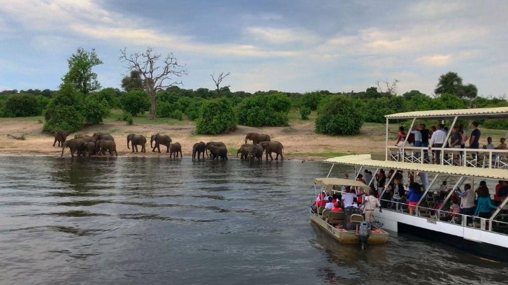
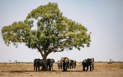
The Okavango Delta is one of Botswana’s most important natural landmarks and a UNESCO World Heritage Site. This vast inland delta is renowned for its abundant wildlife, lush habitats, and vibrant ecosystems, making it a major attraction for eco-tourists and nature enthusiasts. Covering approximately 15,000 square kilometers, the delta supports diverse flora and fauna, including elephants, lions, hippos, and numerous bird species. Its unique seasonal flooding creates a dynamic landscape that is crucial for the region’s biodiversity. The Okavango Delta not only offers breathtaking natural scenery but also plays a vital role in Botswana’s environmental and cultural heritage, symbolizing the country’s rich natural landscape along the matrices of the Botswana Africa map.
Chobe National Park
Chobe National Park is one of the most renowned landmarks in Botswana, Africa, and a key feature on the Botswana Africa map. It is famous for its diverse wildlife and picturesque landscapes, making it a must-visit destination for tourists and nature enthusiasts alike.
- Chobe River: The lifeblood of the park, attracting large concentrations of elephants, buffalo, and hippos.
- Chobe National Park: Covering approximately 11,700 square kilometers, it is home to a rich variety of animals including lions, leopards, and wild dogs.
- Kasane: The gateway town to Chobe, offering accommodation and safari tours.
- Impalala River: A significant water source that sustains wildlife during dry seasons.
- Sedudu/Kasane Island: A natural reserve area within the park providing excellent birdwatching opportunities.
These landmarks and natural reserves highlight the significance of Chobe National Park on the Botswana map, emphasizing its role in conservation and eco-tourism in Southern Africa.
Makgadikgadi Pans
The Makgadikgadi Pans are one of Botswana’s most remarkable natural landmarks, representing one of the largest salt flats in the world. These expansive salt flats are remnants of an ancient lake and are renowned for their stunning, open landscapes that stretch across the region. Alongside the pans, Botswana features numerous natural reserves such as the Moremi Game Reserve and Chobe National Park, which are vital for conservation and eco-tourism. These landmarks offer incredible opportunities for wildlife viewing, including elephants, lions, cheetahs, and numerous bird species. The combination of these natural sites underscores Botswana’s rich ecological diversity and makes it a key destination for nature enthusiasts and travelers exploring the continent’s map of natural wonders.
Moremi Game Reserve
Moremi Game Reserve, located in Botswana, is one of the most important landmarks and natural reserves in the country. Nestled within the Okavango Delta, it is celebrated for its rich biodiversity and pristine wilderness. The reserve offers a unique glimpse into Botswana’s diverse ecosystems, including lush floodplains, dense forests, and open savannahs. Visitors can experience a wide variety of wildlife, such as elephants, lions, leopards, cheetahs, and numerous bird species. Moremi is a vital conservation area that plays a key role in protecting Botswana’s natural heritage and supporting eco-tourism. Its strategic location and scenic beauty make it a highlight on the map of Botswana’s natural landmarks in Africa.
Map Use and Applications
The Botswana Africa map serves as a vital tool for understanding the geography and spatial relationships within the region. Maps are essential for various applications, including navigation, planning, research, and education. They provide visual representations that help users interpret geographical features, administrative boundaries, and natural resources across Botswana and its neighboring areas.
Tourism and Safari Planning
Maps of Botswana Africa play a crucial role in facilitating tourism and safari planning by providing detailed geographic information about the country’s diverse landscapes and wildlife habitats. They help travelers identify key national parks, game reserves, and scenic routes, ensuring a well-organized and enjoyable safari experience. By using these maps, tourists can navigate safely through remote areas, locate accommodations, and plan their itineraries efficiently.
Additionally, Botswana maps are valuable tools for conservation efforts, guiding sustainable tourism practices and protecting natural resources. They assist adventure enthusiasts and wildlife photographers in finding prime locations for observing Africa’s iconic animals, such as elephants, lions, and rhinoceroses. Overall, these maps enhance the safety, convenience, and enjoyment of travelers exploring the rich biodiversity and scenic beauty of Botswana.
Educational and Research Purposes
The Botswana Africa map serves as a valuable tool for both educational and research purposes, providing detailed geographical information about the region. It helps students understand the country’s location, boundaries, and neighboring nations, enhancing their knowledge of African geography. Researchers utilize the map to analyze spatial data, study demographic trends, and plan development projects within Botswana. Additionally, the map assists in navigation, resource management, and environmental conservation efforts, making it an essential resource for educators, students, and researchers exploring Botswana and its place within Africa.
Navigation and Infrastructure Development
The Botswana Africa map is an essential tool for various applications including navigation and infrastructure development across the country. It enables users to accurately locate cities, towns, roads, and geographical features, facilitating efficient travel and logistical planning. Map use in Botswana supports government initiatives aimed at improving transportation networks, connecting rural areas to urban centers, and planning new infrastructure projects. Additionally, the map plays a crucial role in tourism, agriculture, and resource management by providing detailed geographic information. Modern digital maps and GIS technology enhance the precision and accessibility of Botswana’s spatial data, promoting sustainable development and economic growth throughout the region.
Digital and Interactive Maps of Botswana
Digital and interactive maps of Botswana offer a dynamic way to explore the country’s diverse landscapes, cities, and cultural sites. These advanced mapping tools provide detailed geographic information, making it easier for travelers, researchers, and students to navigate and understand Botswana’s unique environment. With user-friendly interfaces and interactive features, these maps bring the rich tapestry of Botswana to life on any device.
Online Map Resources
Digital and interactive maps of Botswana provide an engaging way to explore the country’s diverse geography, cities, and landmarks. These online map resources offer detailed visuals that can be accessed from various devices, making it easier for users to plan travels, study regions, or conduct research about Botswana in Africa. Many platforms incorporate zoom features, layers, and search options to enhance the user experience. Popular online maps such as Google Maps, Bing Maps, and OpenStreetMap include comprehensive coverage of Botswana, highlighting key features like the Okavango Delta, the capital Gaborone, and the Makgadikgadi Salt Pans. These resources serve as valuable tools for tourists, students, and professionals interested in digital exploration of Botswana’s landscapes and locations.
GIS and Spatial Data
Digital and interactive maps of Botswana play a crucial role in visualizing spatial data and geographic information across the country. Utilizing Geographic Information Systems (GIS), these maps enable users to analyze terrain, infrastructure, land use, and environmental features with precision. Interactive maps of Botswana often incorporate layers such as topography, transportation networks, and demographic data, providing valuable insights for planners, researchers, and travelers. The integration of GIS technology facilitates effective decision-making, resource management, and development planning within Botswana and across Africa. Overall, digital mapping solutions enhance our understanding of Botswana’s diverse landscapes and foster sustainable development initiatives through accurate spatial data analysis.
Mapping Technologies and Tools
Digital and interactive maps of Botswana in Africa have revolutionized the way we explore and understand the country’s geography, culture, and resources. These maps utilize advanced mapping technologies to provide detailed, user-friendly visualizations that can be accessed easily through various devices. Mapping technologies such as Geographic Information Systems (GIS), satellite imagery, and GPS have enabled the creation of highly accurate and up-to-date maps of Botswana. These tools support a wide range of applications, from urban planning and environmental management to tourism and education. Interactive maps often include features like zooming, layering, and real-time data updates, offering users an engaging and informative experience. The integration of these technologies ensures that maps of Botswana are more precise, accessible, and versatile, contributing significantly to economic development and research efforts across the region.


0 Comments