Geographical Features of Namibia
Namibia, located in southwestern Africa, boasts a diverse and striking landscape characterized by remarkable geographical features. Its expansive deserts, such as the Namib Desert, are among the oldest in the world and are famous for their towering sand dunes. The country also features rugged mountain ranges like the Brandberg, vast plains, and the stunning Etosha Pan, a large salt flat that forms part of the Etosha National Park. These diverse terrains contribute to Namibia’s unique ecological and scenic appeal, making it a captivating destination for explorers and nature enthusiasts alike.
Desert Landscapes
Namibia is renowned for its dramatic desert landscapes and distinctive geographical features. The country is characterized by vast arid regions, including the expansive Namib Desert, which is one of the oldest deserts in the world. The Namib Desert features towering sand dunes, some reaching over 300 meters in height, such as the iconic Dune 45 near Sossusvlei. In addition to the Namib, Namibia also contains the Kalahari Desert in the east, which is a semi-arid sandy savannah supporting diverse wildlife. The country’s landscape is further shaped by rugged mountain ranges like the Etosha Heights and the Waterberg Plateau, which rise dramatically from the flat desert plains. Extensive clay pans and salt flats, notably around the Etosha Pan, add to the stark beauty of the desert environment. Overall, Namibia’s desert landscapes create a unique geographical footprint that is both visually stunning and ecologically significant in Africa’s map. The country’s geography plays a vital role in its ecosystem, tourism, and cultural history.
Mountains and Plateaus
Namibia, located in southwestern Africa, is characterized by diverse geographical features, particularly its impressive mountains and plateaus. The country is renowned for the Namib Desert, one of the oldest deserts in the world, which dominates much of its landscape. Central Namibia is marked by the Great Escarpment, a prominent geological feature that forms the backbone of the country’s terrain and separates the high inland plateaus from the lower coastal plains. The Namibian interior is primarily a vast, arid plateau that extends across much of the country, hosting a variety of unique ecosystems and landscapes. The central highlands, including the Waterberg Plateau, offer rugged mountain ranges and elevated terrains that are rich in biodiversity and cultural history. These features contribute to Namibia’s striking scenery and diverse environment, making it a unique region in Africa on the map of Namibia.
Rivers and Water Bodies
Namibia, located in the southwestern part of Africa, is characterized by diverse geographical features that include desert plains, mountains, and coastal regions. The country is renowned for the vast Namib Desert, which is one of the oldest deserts in the world and features stunning sand dunes and unique landscapes. The landscape is further marked by the Kalahari Desert in the east, which extends into Botswana and South Africa.
Namibia’s river systems and water bodies play a vital role in shaping its environment. The most prominent river is the Orange River, which forms the southern border of the country and is crucial for water supply and agriculture. Other significant rivers include the Kunene River in the northwest, which flows into the Atlantic Ocean, and the Zambezi River, shared with neighboring countries. The country also has numerous smaller rivers and streams, many of which are seasonal and contribute to the sparse water resources in the region.
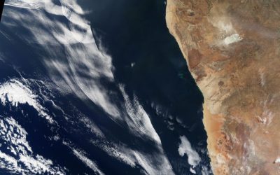
The Atlantic Ocean borders Namibia to the west, providing access to rich marine resources and coastal ecosystems. The country’s water bodies, including its rivers and the Atlantic Ocean, are vital for sustaining life, supporting fishing communities, and contributing to the country’s tourism industry, especially in areas like Walvis Bay. Overall, Namibia’s geographical features and water bodies define its landscape and influence its climate, biodiversity, and human activities.
Political Map of Namibia
The political map of Namibia provides a detailed overview of the country’s administrative boundaries, regions, and major cities. Located in southwestern Africa, Namibia is known for its vast deserts, diverse landscapes, and rich cultural heritage. The map highlights the key territorial divisions that shape the nation’s governance and geography, offering valuable insights into Namibia’s political structure and regional distribution.
Regional Divisions
The political map of Namibia showcases the country’s division into various regional administrations, each serving as an administrative unit to facilitate governance and development. Namibia is divided into 14 regions, which are further subdivided into smaller administrative areas known as constituencies. The regions include Khomas, Erongo, Otjozondjupa, Otavi, Kavango East and West, Zambezi, Kunene, Omusati, Oshana, Oshikoto, Ohangwena, Katanga, and Hardap. These regional divisions help coordinate local government activities and deliver services efficiently across the nation. Namibia’s regional map is a reflection of its diverse cultural and geographical landscape, with each region possessing unique features and significance within the country’s broader context. The political boundaries are marked clearly on the map to assist in administrative, political, and developmental planning across Namibia in Africa.
Major Cities and Capitals
The political map of Namibia highlights the country’s major cities and capitals, showcasing its administrative divisions and urban centers. Namibia is located in southwestern Africa and is known for its diverse landscapes, including deserts, savannahs, and coastal areas. The capital city is Windhoek, which serves as the political, economic, and cultural hub of the nation. Other significant cities include Swakopmund, known for its German colonial architecture and coastal attractions; Walvis Bay, an important port city; and Oshakati, a key center in the northern region. These urban areas play vital roles in the country’s governance, commerce, and development, making them prominent features on the Namibia map of Africa.
Bordering Countries
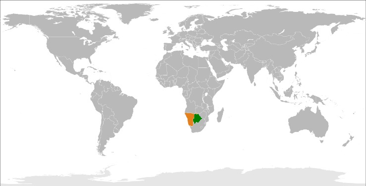
The political map of Namibia distinctly showcases its position in southwestern Africa, highlighting its borders and neighboring countries. Namibia shares borders with Angola to the north, Zambia to the northeast, Botswana to the east, Zimbabwe to the northeast, and South Africa to the south and southeast. The Atlantic Ocean forms its western boundary, providing Namibia with an extensive coastline. This strategic placement influences its regional interactions and land connectivity with surrounding nations, shaping its geopolitical landscape within the African continent.
Natural Attractions and Landmarks
Namibia, located in the southwestern part of Africa, is renowned for its stunning natural attractions and iconic landmarks. From vast deserts to diverse wildlife and dramatic landscapes, Namibia offers a unique blend of natural beauty that captivates travelers and nature enthusiasts alike. Exploring these remarkable sites provides a glimpse into the country’s pristine environment and rich ecological heritage.
Namib Desert
The Namib Desert, located in Namibia, is one of the world’s oldest and most breathtaking natural attractions. Covering approximately 55,000 square kilometers, this iconic desert features towering sand dunes, some of the tallest in the world, such as Dune 45 and Big Daddy. Its surreal landscape creates a striking contrast against the clear blue skies and offers a unique habitat for diverse flora and fauna adapted to its extreme conditions. Visitors to Namibia can explore spectacular landmarks such as the Deadvlei, famous for its white clay pan dotted with ancient, dead camelthorn trees, and Sossusvlei, a must-see site for photographers and nature enthusiasts. The Namib Desert’s awe-inspiring scenery and rich biodiversity make it a top natural attraction in Namibia and a highlight on the Africa map.
Sossusvlei Dunes
Namibia, located in southwestern Africa, is renowned for its stunning natural attractions and iconic landmarks, one of which is the Sossusvlei Dunes. These towering desert dunes are among the highest in the world, with some reaching over 300 meters in height, creating a breathtaking landscape of vibrant red and orange hues. The dunes are part of the Namib Desert, which is often considered the oldest desert on Earth, showcasing a unique ecosystem. Visitors flock to Sossusvlei to experience the surreal scenery, climb the dunes for panoramic views, and explore the surrounding Deadvlei, known for its hauntingly preserved white clay pan and dead camelthorn trees. This area exemplifies Namibia’s dramatic natural beauty and makes it a must-visit destination for nature enthusiasts and photographers alike.
Etosha National Park
Etosha National Park, located in Namibia, is one of Africa’s most renowned natural attractions and a top destination for wildlife enthusiasts. Covering approximately 22,750 square kilometers, it is famous for its vast saline desert and the abundant wildlife that congregates around its numerous waterholes. Visitors can experience the thrill of spotting elephants, lions, rhinoceros, cheetahs, and various antelope species in their natural habitat. The park’s unique landscape includes expansive salt pans, lush grasslands, and mopane woodlands, making it a diverse and picturesque environment.
One of the landmark highlights within Etosha is the Etosha Pan, a massive, shimmering salt pan that is often flooded during the rainy season, attracting thousands of birds and other wildlife. The park’s waterholes serve as natural gathering points, offering excellent opportunities for game viewing and photography. Etosha National Park not only showcases Namibia’s remarkable biodiversity but also offers a glimpse into the country’s contrasting landscapes, from arid deserts to lush water bodies, making it a key feature on the map of Namibia in Africa.
Economic and Cultural Regions
Namibia’s diverse landscape and rich cultural heritage are reflected in its economic and cultural regions. These regions highlight the country’s unique blend of indigenous traditions, colonial influences, and modern development. Understanding Namibia’s regional divisions provides insight into its economic activities and cultural diversity across the African map.
Mining Areas
Namibia is predominantly characterized by distinct economic and cultural regions that influence its development and identity. The country’s economic regions are often centered around key industries such as mining, agriculture, and tourism. The mineral-rich areas, particularly in the central and northern parts, include mining areas for resources like uranium, diamonds, and copper, which play a significant role in Namibia’s economy. These mining zones attract investment and provide employment opportunities, shaping regional economic strength.
Culturally, Namibia is diverse, with various ethnic groups such as the Ovambo, Herero, Damara, and San communities. These groups inhabit specific regions that reflect their traditions and histories, creating a mosaic of cultural regions across the country. The central and northern regions tend to be more ethnically dense and culturally vibrant, with distinct languages, customs, and festivals, which contribute to Namibia’s rich cultural heritage.
On the map of Namibia in Africa, these economic and cultural regions often overlap, with mining areas situated near major towns and cultural centers. Recognizing these regions helps in understanding the country’s socio-economic dynamics and geographic diversity, illustrating how Namibia’s natural resources and cultural identity are geographically distributed across its landscape.
Agricultural Zones
Namibia, located in southwestern Africa, is characterized by diverse economic and cultural regions that influence its development and social fabric. The country’s economy is largely driven by mining, agriculture, and tourism, which vary across different regions. The coastal areas, especially around Walvis Bay and Swakopmund, serve as vital economic hubs with significant port activity and industrial development, while the interior regions focus more on herding and subsistence farming.
Culturally, Namibia exhibits a rich mosaic of ethnic groups, including the Himba, Herero, Nama, and San peoples, each with distinct traditions and practices. These cultural regions often align with geographic and historical patterns, contributing to the nation’s diverse identity. The central regions of Windhoek act as the political and economic capital, fostering a blend of urban and traditional cultures.
Within agricultural zones, Namibia is divided into areas suited for different types of farming. The central plateau with its semi-arid conditions supports extensive cattle grazing and pastoralism, which are central to Namibian agriculture. The more arid desert regions, such as the Namib, are less suitable for farming but are notable for mining activities, including uranium and minerals. The fertile northern regions, with higher rainfall, are used for subsistence farming of crops like millet and sorghum, supporting local communities.
Cultural Landmarks
Namibia, located in southwestern Africa, is a country rich in both economic and cultural regions that contribute to its unique identity. Economically, Namibia is known for its natural resources, including diamonds, uranium, and other minerals, which play a crucial role in its development. The coastal region around Walvis Bay and Swakopmund holds significant economic importance due to port facilities and industry. Culturally, Namibia is diverse, showcasing various ethnic groups such as the Himba, Herero, and San communities, each with distinct traditions and customs.
Prominent cultural landmarks in Namibia include the ancient rock art at Twyfelfontein, a UNESCO World Heritage Site, which highlights the country’s rich historical heritage. The Etosha National Park is a famous wildlife reserve that attracts tourists from around the world, serving as both a natural and cultural treasure. The colonial-era structures in Windhoek and Lüderitz reflect historical influences, while traditional villages offer insight into indigenous lifestyles. These cultural landmarks, together with Namibia’s diverse regions, paint a vivid picture of the country’s heritage and economic landscape within the broader map of Africa.
Environmental and Conservation Areas
Namibia, located in southwestern Africa, is renowned for its diverse environmental and conservation areas that showcase stunning landscapes and rich biodiversity. The country’s commitment to preserving its natural heritage is evident through its numerous national parks and protected regions, making it a vital destination for eco-tourism and wildlife conservation. These areas play a crucial role in maintaining Namibia’s unique ecosystems and offering visitors an opportunity to experience extraordinary natural beauty.
Wildlife Reserves
Namibia, situated in southwestern Africa, boasts a diverse range of environmental and conservation areas that are vital for preserving its unique ecosystems and wildlife. The country is renowned for its incredible landscapes, including the Namib Desert, which is one of the world’s oldest deserts. Namibia has established numerous wildlife reserves and national parks to protect its rich biodiversity, such as Etosha National Park, which provides a sanctuary for elephants, lions, rhinoceroses, and other species. These conservation areas play a crucial role in maintaining ecological balance and promoting sustainable tourism. Efforts to conserve Namibia’s environment also focus on combating poaching and habitat destruction, ensuring that future generations can enjoy its natural heritage. Overall, Namibia’s environmental and wildlife reserves are essential components of its identity and ecological stability within Africa.
Protected Areas
Namibia, located in southern Africa, is renowned for its vast landscapes and rich biodiversity, making it a significant area for environmental conservation. The country has established numerous protected and conservation areas to preserve its unique ecosystems and endangered species, such as the Namib Desert, Etosha National Park, and Skeleton Coast Park. These areas play a crucial role in safeguarding wildlife habitats, promoting sustainable tourism, and maintaining ecological balance. Namibia’s commitment to environmental preservation reflects its recognition of natural resources as vital for both ecological health and socio-economic development. Efforts to protect these areas ensure that Namibia’s natural beauty and biodiversity are preserved for future generations, making it a vital part of Africa’s environmental landscape.
Marine Conservation Zones
Namibia, located in southwestern Africa, is known for its remarkable natural beauty and extensive conservation efforts. The country features diverse landscapes, including deserts, savannas, and coastal areas, which are home to unique flora and fauna. Environmental and conservation areas play a crucial role in protecting Namibia’s rich biodiversity. Marine Conservation Zones along Namibia’s Atlantic coast are especially important, safeguarding vital marine habitats and supporting sustainable fishing practices. These zones help preserve species such as seals, dolphins, and tuna, contributing to the health of the ocean ecosystem. Namibia’s commitment to conservation reflects its recognition of the importance of maintaining ecological balance and promoting eco-tourism, which benefits both the environment and local communities.

0 Comments