
Geographical Overview of Tanzania
Tanzania, located in East Africa, is known for its diverse landscapes and rich cultural heritage. It is bordered by Kenya and Uganda to the north, Rwanda, Burundi, and the Democratic Republic of the Congo to the west, and Zambia, Malawi, and Mozambique to the south. The country features a variety of geographical features, including the iconic Mount Kilimanjaro, the Serengeti plains, and the Great Rift Valley. Its extensive coastline along the Indian Ocean adds to its ecological and economic significance, making Tanzania a geographically fascinating nation with a wealth of natural beauty.
Location and Boundaries
Tanzania is a country located in East Africa, renowned for its diverse landscapes and rich natural resources. It is situated on the eastern coast of the continent, bordered by Kenya and Uganda to the north, Rwanda, Burundi, and the Democratic Republic of Congo to the west, and Zambia, Malawi, and Mozambique to the south. To the east, it has a lengthy coastline along the Indian Ocean. The country shares land boundaries with eight nations, making it a vital part of the East African Community. Its strategic geographical position, combined with prominent features such as Mount Kilimanjaro and the Serengeti landscape, makes Tanzania a unique and important nation in the region.
Major Landforms
Tanzania is a country located in East Africa, renowned for its diverse geographic landscape. It features a wide range of landforms, from expansive plains to towering mountains and vast lakes. The country’s geographical features play a significant role in its climate, biodiversity, and human settlement patterns.
Major landforms in Tanzania include the Great Rift Valley, which runs from the north to the south, creating a series of deep valleys and highlands. The Serengeti Plains are vast, flat grasslands famous for wildlife migration. The country is also home to the Serengeti National Park and the Ngorongoro Crater, both situated within these lowlands.
Mount Kilimanjaro, Africa’s highest peak, is located in northeastern Tanzania and is part of the Eastern Arc Mountains. The country is bordered by large lakes such as Lake Victoria to the northwest, Lake Tanganyika to the west, and Lake Malawi to the southwest, which are crucial for transportation and fishing industries. Additionally, Tanzania has a rugged coastline along the Indian Ocean, featuring coral reefs and beaches.
These diverse landforms make Tanzania a rich country in terms of natural resources and ecological zones, attracting tourism and supporting local communities across the nation.
Climate Zones
Tanzania, located in East Africa, features a diverse geographical landscape that includes coastal plains, highlands, and the Great Rift Valley. The country is bordered by Kenya, Uganda, Rwanda, Burundi, the Democratic Republic of the Congo, Zambia, Malawi, and Mozambique, with a coastline along the Indian Ocean. Its terrain varies from low-lying coastal areas to mountainous regions, including Mount Kilimanjaro, the tallest peak in Africa.
The climate zones in Tanzania are equally diverse, ranging from tropical along the coast to temperate in the highland areas. The coastal region experiences hot and humid conditions with a distinct rainy season, supporting lush vegetation and several marine ecosystems. The inland highlands have a more temperate climate with cooler temperatures and are suitable for agriculture and settlement. The Great Rift Valley exhibits a semi-arid climate, with some areas receiving minimal rainfall, influencing the local flora and fauna. Overall, Tanzania’s varied climate zones contribute to its rich biodiversity and diverse landscapes.
Key Features of Tanzania Map
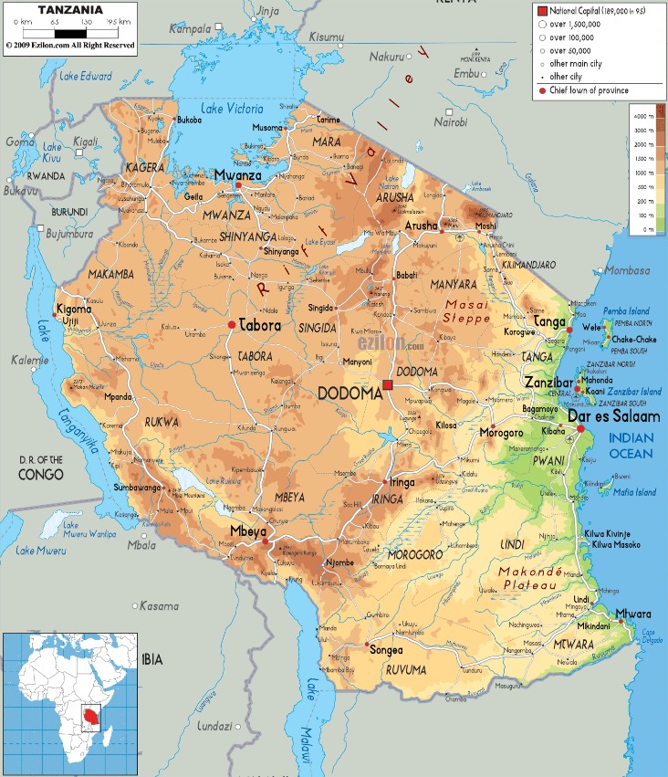
The Tanzania map showcases the country’s diverse geographical features, vibrant cities, and significant landmarks. It provides detailed insights into regions such as the Serengeti, Mount Kilimanjaro, and the Zanzibar archipelago. This map is an essential tool for travelers, researchers, and anyone interested in exploring Tanzania’s rich natural and cultural heritage.
Main Cities and Urban Areas
Tanzania mapa showcases a diverse and expansive geographic landscape, featuring prominent natural features such as Mount Kilimanjaro, the Serengeti plains, and Lake Victoria. The map highlights key transportation routes, national parks, and regional boundaries, providing a comprehensive view of the country’s topography. Main cities and urban areas include Dar es Salaam, the economic hub and largest city, alongside Dodoma, the political capital. Other significant urban centers are Arusha, known for tourism and safaris, Mwanza, situated near Lake Victoria, and Mbeya, a vital commercial and agricultural center in the south. The map offers valuable insights into Tanzania’s infrastructure, population distribution, and regional divisions, making it an essential tool for understanding the country’s geography and development.
Natural Landmarks
The Tanzania map highlights the country’s diverse geography, showcasing its extensive landmass and notable natural features. Key features include the Serengeti Plains, famous for their vast savannahs and wildlife safaris, and the Ngorongoro Crater, a UNESCO World Heritage site known for its incredible biodiversity. The map also displays Lake Victoria to the northwest, one of Africa’s largest freshwater lakes, and Lake Tanganyika in the western part, renowned as the world’s second deepest freshwater lake. Mount Kilimanjaro, the highest peak in Africa, is prominently marked, attracting many explorers and climbers. Other natural landmarks include the Selous Game Reserve and Tarangire National Park, both significant for their thriving ecosystems and wildlife conservation efforts. The map provides a comprehensive overview of Tanzania’s rich natural landscape, essential for understanding its ecological significance and tourist appeal.
Rivers and Lakes
The Tanzania map highlights several key geographical features that define the country’s landscape, including its major rivers, lakes, and topographical elements. These features are essential for understanding Tanzania’s natural environment, ecological diversity, and regional geography.
- Major Lakes: Tanzania is home to several large lakes, including Lake Victoria, the second-largest freshwater lake in the world, and Lake Tanganyika, one of the deepest and oldest freshwater lakes.
- Important Rivers: The country features significant rivers such as the Rufiji River, which is vital for hydroelectric power and agriculture, and the Pangani River that flows to the Indian Ocean.
- Topography: The map displays the varying elevations, from the coastal plains to the high peaks of Mount Kilimanjaro, Africa’s highest mountain.
- National Parks and Reserves: Key protected areas like Serengeti National Park, known for its wildlife migration, are marked on the map.
- Boundary Lines: The map also shows Tanzania’s borders with bordering countries such as Kenya, Uganda, Rwanda, Burundi, the Democratic Republic of the Congo, Zambia, Malawi, and Mozambique.
National Parks and Reserves
National parks and reserves in Tanzania are some of the most breathtaking natural areas in Africa, offering a sanctuary for diverse wildlife and stunning landscapes. These protected regions play a crucial role in conservation and provide visitors with unforgettable experiences in nature. Exploring Tanzania’s mapa reveals the location and extent of these remarkable parks, showcasing the country’s commitment to preserving its rich ecological heritage.
Serengeti National Park
The Tanzania mapa highlights some of the most iconic natural attractions, including the Serengeti National Park, which is renowned for its vast savannahs and abundant wildlife. Serengeti National Park is a UNESCO World Heritage Site and one of Africa’s premier safari destinations, famous for the annual migration of over two million wildebeest and zebras. Visitors can experience incredible game drives, spotting elephants, lions, cheetahs, and many other species in their natural habitat. The park’s diverse landscapes also include lush woodlands, river valleys, and rocky outcrops, making it a vital part of Tanzania’s rich conservation efforts. Alongside other national parks and reserves, Serengeti plays a crucial role in preserving Tanzania’s unique biodiversity and attracting eco-tourists from around the world.
Ngorongoro Conservation Area
The Ngorongoro Conservation Area is one of Tanzania’s most famous national parks and reserves, renowned for its stunning landscapes and rich biodiversity. Located in northern Tanzania, it encompasses the Ngorongoro Crater, often called the eighth natural wonder of the world, which provides a unique habitat for numerous animal species. This UNESCO World Heritage Site is a crucial part of Tanzania’s extensive network of protected areas, contributing significantly to wildlife conservation and tourism. Visitors to the Tanzania mapa can explore the diverse ecosystems of the Ngorongoro Conservation Area, where they have the opportunity to see elephants, lions, rhinos, and various bird species in their natural environment while also experiencing the local Maasai culture. The area’s unique combination of wilderness and cultural heritage makes it an essential destination for nature lovers and adventure seekers alike.
Mount Kilimanjaro National Park
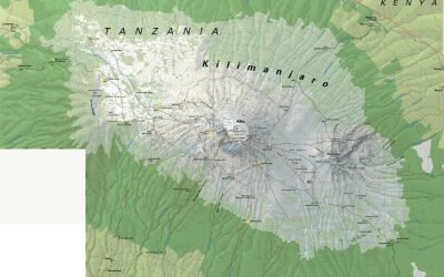
Mount Kilimanjaro National Park is one of Tanzania’s most renowned national parks and a UNESCO World Heritage Site. Located in northeastern Tanzania, this park is famous for encompassing Mount Kilimanjaro, the highest peak in Africa at 5,895 meters. The park offers diverse landscapes, ranging from lush montane forests to alpine desert and glacial summit regions. Visitors are drawn to the park for its challenging and rewarding treks to the summit, as well as for its rich biodiversity, including elephants, leopards, and numerous bird species. The Tanzania mapa highlights the park’s significance and accessibility, making it a key destination for adventure seekers and nature enthusiasts alike.
Selous Game Reserve
The Selous Game Reserve, located in Tanzania, is one of the largest faunal reserves in the world and a UNESCO World Heritage Site. It spans over 50,000 square kilometers and is renowned for its diverse ecosystems, including rivers, lakes, and woodlands, which support a wide variety of wildlife. The reserve is home to elephants, lions, rhinoceroses, cheetahs, and numerous bird species, making it a popular destination for safari enthusiasts.
Within the Tanzania mapa, the Selous Game Reserve stands out as a vital protected area that plays a crucial role in conserving biodiversity and supporting local communities through eco-tourism. Visitors can explore the reserve by boat, on foot, or in 4×4 vehicles, experiencing the stunning landscapes and abundant wildlife firsthand. Its remote location offers an authentic safari experience away from crowded tourist spots.
Administrative Divisions
Administrative divisions are essential for organizing and managing the governance of a country. They help in implementing policies, delivering services, and maintaining order across different regions. In the context of Tanzania, these divisions play a crucial role in shaping the country’s administrative, political, and geographical landscape. Understanding Tanzania’s mapa and its various divisions provides insight into how the nation is structured and administered.
Regions of Tanzania
The regions of Tanzania are a vital part of the country’s administrative divisions, each serving as a primary unit for governance and local administration. Tanzania is divided into 31 regions, which are further subdivided into districts and wards. These regions play a crucial role in managing local development projects, resource distribution, and political representation. Some of the most prominent regions include Dar es Salaam, Arusha, Dodoma (the national capital), Kilimanjaro, and Mwanza. The regional boundaries are marked on Tanzanian maps, illustrating the country’s diverse geographic and cultural landscape. The regional organization helps streamline governance and enhances service delivery, making Tanzania a well-structured nation. The map of Tanzania provides a visual overview of these regions, highlighting their geographical locations and relationships within the country.
Major Districts
Tanzania is divided into several administrative divisions and major districts that facilitate local governance and regional administration. These divisions help organize the country’s resources, development projects, and administrative functions efficiently.
- Arusha Region: includes districts such as Arusha Urban, Arusha District, and Longido.
- Dar es Salaam Region: encompasses districts like Ilala, Kinondoni, and Temeke.
- Dodoma Region: features Dodoma Urban and Chamwino districts.
- Mbeya Region: comprises Mbeya Urban, Chunya, and Rungwe districts.
- Arusha Region: including Arusha Urban, Meru, and Monduli districts.
- Mwanza Region: with districts such as Ilemela, Misungwi, and Nyamagana.
- Morogoro Region: covering Morogoro Urban, Morogoro Rural, and Kilosa.
- Iringa Region: including Iringa Urban, Kilolo, and Mufindi districts.
- Manyara Region: consisting of Babati, Hanang, and Mbulu districts.
- Rukwa Region: comprising Sumbawanga Urban, Sumbawanga Rural, and Nkasi districts.
Local Government Structure
In Tanzania, the administrative divisions and local government structure are designed to facilitate effective governance and administrative management across the country. The country is divided into several hierarchical levels, beginning with regions, which serve as the largest administrative units. Each region is further subdivided into districts, which handle local administrative functions and service delivery.
Districts are divided into smaller units called wards, which are responsible for local governance at a community level. Wards consist of several neighborhoods or villages, with local councils managing day-to-day affairs. The local government system in Tanzania aims to promote decentralization, allowing local authorities to plan, implement, and oversee development activities effectively. This structure ensures that governance is accessible at various levels, fostering participation and ensuring that resources are allocated according to local needs. The central government maintains oversight through regional and district councils, which coordinate broader national policies and development initiatives across the country’s diverse regions.
Transportation Infrastructure
Transportation infrastructure plays a vital role in the development and connectivity of Tanzania. It includes roads, railways, ports, and airports that facilitate the movement of people and goods across the country. A well-developed transportation network is essential for economic growth, trade, and improving access to services. Understanding Tanzania’s transportation infrastructure provides valuable insights into its overall development and regional integration.
Major Roads and Highways
Transportation infrastructure, including major roads and highways, plays a vital role in the development of Tanzania. These routes facilitate the movement of goods and people across the country, supporting economic growth and regional connectivity.
- 1. Tanzanian Highway Network: The country boasts an extensive network of national highways connecting key cities such as Dar es Salaam, Arusha, Mwanza, and Dodoma.
- 2. Major Highways: Notable roads include the Tanzania-Zambia Highway (TZC), the Central Corridor, and the Northern Corridor, which link Tanzania to neighboring countries and the rest of East Africa.
- 3. Road Quality and Expansion: Continuous efforts are underway to improve and expand major roads, ensuring safer and more efficient transportation across urban and rural areas.
- 4. Challenges: Despite improvements, challenges such as road maintenance, funding, and infrastructure development in remote regions remain priorities for national development.
- 5. Future Developments: Ongoing projects aim to upgrade existing highways, build new expressways, and enhance connectivity, supporting Tanzania’s long-term economic ambitions.
Rail Networks
Tanzania’s transportation infrastructure, particularly its rail networks, plays a vital role in connecting various regions and facilitating economic growth. The country’s rail system primarily consists of the Tanzania Standard Gauge Railway (SGR) and several inland rail lines that support freight and passenger movement. The SGR, a significant modernization project, aims to improve connectivity with neighboring countries and reduce transportation costs. Rail networks in Tanzania are crucial for transporting goods such as minerals, agricultural products, and manufactured goods, enhancing trade within East Africa. The development of efficient rail infrastructure is essential for promoting regional integration and supporting Tanzania’s development goals.
Airports and Ports
Tanzania’s transportation infrastructure plays a vital role in connecting its regions and facilitating economic growth. The country boasts a network of airports and ports that are crucial for both domestic and international trade, tourism, and transportation.
- Airports: Tanzania has several international airports, with Julius Nyerere International Airport in Dar es Salaam being the largest and busiest. Other notable airports include Kilimanjaro International Airport, which serves tourists heading to Mount Kilimanjaro, and Abeid Amani Karume International Airport in Zanzibar.
- Ports: The main seaports include the Port of Dar es Salaam, one of East Africa’s largest and busiest ports, handling a significant portion of the country’s import and export activities. Other important ports are Zanzibar port and Tanga port, which support regional trade and maritime activities.
These transportation hubs are integral to Tanzania’s development and play a key role in expanding its trade links, supporting tourism, and connecting rural communities to national and international markets.
Economic and Cultural Highlights
Tanzania offers a fascinating blend of economic growth and cultural richness, making it a captivating destination for travelers and researchers alike. Its diverse landscapes support vibrant industries, from agriculture to tourism, while its rich cultural heritage is reflected in traditional customs, music, and art. Exploring the Tanzania mapa reveals the country’s unique combination of natural beauty and dynamic economic development that defines its identity today.
Natural Resources
Tanzania, known for its rich cultural diversity and vibrant history, boasts a dynamic economy fueled by agriculture, tourism, and mining sectors. The country is renowned for its traditional music, dance, and art forms that reflect its varied ethnic groups. Natural resources play a significant role in Tanzania’s economic landscape, with abundant minerals, including gold, diamonds, and tanzanite, which is unique to the region. Additionally, Tanzania’s natural beauty, from the Serengeti plains to Mount Kilimanjaro, attracts millions of tourists annually, contributing substantially to its national income.
Tourist Attractions
Tanzania, renowned for its diverse landscapes and rich cultural heritage, offers a wealth of economic and cultural highlights as well as captivating tourist attractions. The country’s economy benefits from agriculture, tourism, and mineral resources, contributing significantly to its development. Culturally, Tanzania is home to numerous ethnic groups, each with unique traditions, music, and art, creating a vibrant cultural tapestry. Tourist attractions include the iconic Serengeti National Park, famous for the Great Migration of wildebeest and zebra, and Mount Kilimanjaro, the world’s highest free-standing mountain, attracting adventure seekers from around the globe. The Ngorongoro Conservation Area provides breathtaking wildlife safaris, while the white sandy beaches of Zanzibar offer tranquil seaside experiences. Overall, Tanzania’s map highlights its diverse natural attractions and rich cultural landscapes, making it a premier destination for travelers seeking both adventure and cultural immersion.
Cultural and Ethnic Diversity
Tanzania is a country rich in economic and cultural significance, with diverse landscapes that range from savannahs to mountains. Its economy is primarily driven by agriculture, tourism, and natural resources such as minerals and gas. The nation has experienced steady growth, attracting investments and fostering development in various sectors.
Culturally, Tanzania boasts a vibrant tapestry of traditions, music, dance, and art that reflect its diverse ethnic groups. The country is home to over 120 ethnic communities, each with unique customs and languages. This cultural plurality is evident in its colorful festivals, cuisine, and social practices, making Tanzania a mosaic of cultural heritage.

0 Comments