.jpeg")
Geographical Overview of Ghana
Ghana, located in West Africa, is a country characterized by diverse landscapes that include coastal savannahs, dense forests, and the inland dry grasslands. Its strategic position along the Gulf of Guinea provides it with a rich cultural heritage and significant historical importance. The geographical features of Ghana contribute to its vibrant ecosystems and support a variety of economic activities such as agriculture, mining, and tourism. Understanding Ghana’s geographical overview is essential for appreciating its place on the Africa map and its role within the region.
Location and Coordinates
Ghana is a West African country situated along the Gulf of Guinea and the Atlantic Ocean. It is known for its diverse landscapes, including coastal savannahs, forests, and lakes, making it a prominent feature on the Africa map. Its geographical position grants it strategic importance and rich natural resources.
- Location: Western Africa, along the Gulf of Guinea
- Coordinates: approximately 5° and 12° North latitude, 1.5° and 3.5° West longitude
Borders and Adjacent Countries
Ghana is a country located along the Gulf of Guinea in West Africa, known for its diverse geography which includes coastal plains, rainforests, and savannahs. It shares borders with several neighboring countries, making it a central part of the West African region. To the west, Ghana is bordered by Ivory Coast (Côte d’Ivoire), while to the north, it shares a boundary with Burkina Faso. On the eastern side, Ghana borders Togo, and to the south, it has a coastline along the Atlantic Ocean. Its strategic location and extensive borders with these countries contribute to its importance in regional trade and cultural exchange across Africa. The Ghana Africa map highlights these borders and the adjacent countries, illustrating Ghana’s position within West Africa.
Size and Territorial Divisions
Ghana is a West African country located along the Gulf of Guinea and the Atlantic Ocean. It covers an area of approximately 238,535 square kilometers, making it one of the smaller countries on the continent, yet it boasts diverse geographical features.
Territorially, Ghana is divided into sixteen administrative regions, which are further subdivided into districts. These regions include the Greater Accra, Ashanti, Central, and Northern regions, each characterized by distinct landscapes and cultural identities. The country features a mix of coastal savannahs, rainforests, and semi-arid zones, contributing to its rich ecological diversity.
Topographical Features
Ghana, located in West Africa, boasts a diverse and intriguing topographical landscape that greatly influences its climate, biodiversity, and human activities. From the lush coastal plains to the rolling savannahs and the rugged mountainous regions, the topographical features of Ghana create a unique environment that shapes the country’s geographical identity. Understanding these features is essential for exploring Ghana’s natural beauty and geographical significance on the African map.
Mountain Ranges and Highlands
Ghana’s topographical features, mountain ranges, and highlands play a significant role in shaping its landscape and climate. The country is characterized by a variety of physical features that include coastal plains, interior highlands, and mountain ranges. The most prominent mountain range in Ghana is the Akwapim-Togo Range, which stretches along the eastern border with Togo. These mountains are part of the larger West African mountainous system and influence the local weather patterns and river systems. The Volta Highlands, located in the eastern part of the country, are known for their elevated terrain and rolling hills. Additionally, the Ashanti uplands in the central region feature numerous hills and small mountains that contribute to Ghana’s diverse topography. These highlands and mountain ranges are vital for agriculture, water resources, and tourism, and they define much of Ghana’s physical landscape across the Africa map.
Plains and Lowlands
Ghana, located in West Africa, is characterized by diverse topographical features, including extensive plains and lowlands that shape its landscape and influence its climate and agriculture.
- Ghana’s plains cover a significant portion of the country, particularly in the northern regions, providing fertile ground for farming and habitation.
- The coastal plains along the Atlantic Ocean are relatively flat and facilitate trade and urban development in cities like Accra.
- Lowland areas in Ghana are often near rivers and water bodies, offering rich alluvial soil suitable for crops such as cocoa and yams.
- Beyond the plains, Ghana features highlands and mountains in the south-west, but the plains remain dominant in the country’s topography.
- This combination of plains and lowlands contributes to Ghana’s diverse ecological zones and supports various economic activities across the map of Ghana in Africa.
Coastal and Marine Ecosystems
The topographical features, coastal, and marine ecosystems of Ghana play a vital role in shaping the country’s geography and environment. Ghana is characterized by diverse landscapes including low plains, highlands, and river valleys that contribute to its varied terrain. The coastline stretches approximately 550 kilometers along the Gulf of Guinea, featuring sandy beaches, rocky cliffs, and estuaries. Coastal ecosystems such as mangroves, wetlands, and lagoons provide critical habitats for numerous species and support local livelihoods through fishing and tourism. Marine ecosystems in Ghana are rich in biodiversity, hosting coral reefs, seagrass beds, and diverse fish populations. These ecosystems are integral to maintaining ecological balance, protecting shorelines from erosion, and sustaining the fishing industry, which is a key economic activity in the country. Overall, Ghana’s topography along with its coastal and marine features highlights the importance of conserving these natural assets for environmental stability and sustainable development.
Major Cities and Urban Centers
Major cities and urban centers play a vital role in shaping the cultural, economic, and social landscape of Ghana, Africa. These bustling hubs serve as focal points for trade, education, and innovation, reflecting the rich diversity and vibrant history of the nation. Understanding the distribution and significance of these urban areas provides valuable insights into Ghana’s development and geographic identity, especially in relation to the country’s map of Ghana in Africa.
Accra: The Capital City
Accra is the vibrant capital city of Ghana and serves as the political, economic, and cultural heart of the country. As a major urban center, it boasts a diverse population and a dynamic skyline filled with modern buildings and historic landmarks. The city is known for its bustling markets, lively streets, and significant role in Ghana’s development and international relations.
Kumasi: Cultural Hub
Kumasi, often regarded as the cultural capital of Ghana, is a vibrant major city and an important urban center in West Africa. As the capital of the Ashanti Region, Kumasi boasts a rich history rooted in the Ashanti Empire, which is reflected in its numerous cultural sites, traditional festivals, and bustling markets. The city is renowned for its impressive craftsmanship, especially in goldsmithing and Kente cloth weaving, showcasing Ghana’s diverse heritage. Kumasi serves as a key economic hub, with a growing population and significant contributions to commerce, education, and tourism. Its strategic location on the Ghana Africa map highlights its importance both historically and in contemporary Ghanaian society, making it a vital city in the country’s development and cultural expression.
Takoradi and Sekondi: Oil and Port City
Takoradi and Sekondi, often collectively known as the Twin Cities, are major urban centers in Ghana located along the coast. These cities are an essential part of Ghana’s economic landscape, serving as key hubs for oil industries and port activities. Their strategic location and vibrant urban life make them significant cities within the Ghana Africa map.
- Takoradi is renowned for its busy port, which facilitates the export of Ghanaian oil, cocoa, and other goods.
- Sekondi, closely linked to Takoradi, has developed as an important commercial and residential area, supporting the industrial activities of the region.
- The cities are home to several oil refineries and related industries, making them central to Ghana’s oil sector.
- Urban development in Takoradi and Sekondi has led to modern infrastructure, including markets, schools, and transportation networks.
- These cities contribute significantly to local employment and regional economic growth as highlighted on the Ghana Africa map.
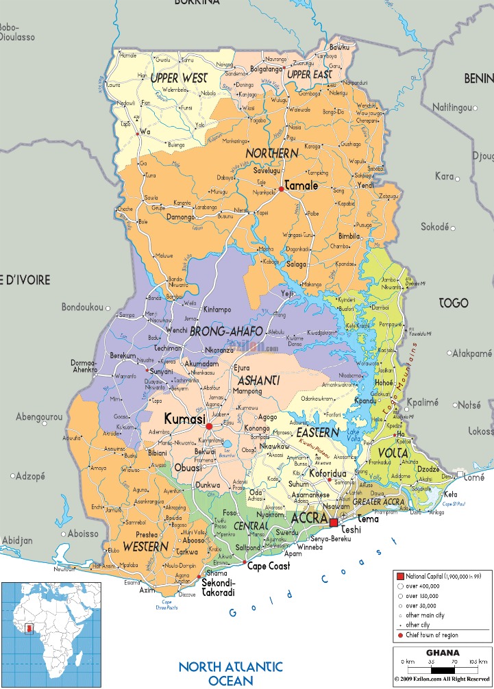
Administrative Regions
Administrative regions are fundamental divisions within a country that help organize governance, resource management, and development efforts. In the context of Ghana, Africa, these regions play a crucial role in shaping local administration, cultural identity, and regional development. Understanding the map of Ghana’s administrative regions provides insight into the country’s diverse landscape and administrative structure.
Overview of the 16 Regions
Ghana is divided into 16 administrative regions, each playing a vital role in the country’s governance and development. These regions vary in size, population, and cultural heritage, reflecting the diversity of Ghana’s landscape and people. The regions are Greater Accra, Ashanti, Northern, Western, Eastern, Central, Volta, Bono, Brong-Ahafo, Ahafo, Oti, Savannah, North East, Upper East, Upper West, and Western North. Each region has its unique identity, economic activities, and tourist attractions, contributing to the rich tapestry of Ghana’s national identity. Understanding these regions provides valuable insight into Ghana’s geographic and administrative structure, especially when exploring maps of the country across Africa. They serve as important units for regional development, resource management, and local governance, shaping the nation’s progress towards growth and stability.
Regional Capitals
Ghana, located in West Africa, is divided into several administrative regions, each governed by a regional capital. These regions include the Ashanti, Greater Accra, Central, Eastern, Western, Northern, and others, forming a hierarchical structure for local governance. The regional capitals serve as the political and administrative centers, hosting regional offices and institutions that coordinate development and public services. Understanding the map of Ghana and its administrative regions helps in recognizing the diversity and organization of the country, which is vital for development planning, tourism, and understanding regional cultures.
Roles and Responsibilities within Administrative Divisions
Within the administrative divisions of Ghana, various regions are established to facilitate governance and development. Each administrative region is overseen by regional authorities responsible for implementing national policies and coordinating local initiatives. These regional roles typically include overseeing infrastructure projects, education, health services, and economic development within their jurisdictions.
At the local level, district assemblies serve as pivotal administrative units, handling local governance, planning, and resource allocation. These roles include managing public services, local economic activities, and community development programs. The leadership within these divisions often comprises regional ministers, district chiefs, and local government officials who work together to ensure effective administration and service delivery across Ghana’s diverse regions.
Natural Resources and Land Use
Ghana, a country located in West Africa, is known for its rich natural resources and diverse land use. The nation’s land is utilized for agriculture, mining, forestry, and urban development, reflecting its economic priorities and environmental landscape. Understanding Ghana’s land and resource distribution is essential for appreciating its geographical significance within the Africa map and its role in regional prosperity.
Mineral Resources
Ghana, located in West Africa, is rich in natural resources, including significant mineral deposits that play a vital role in its economy. The country’s land use is divided among agriculture, urban development, and mining activities, with mineral resources such as gold, bauxite, manganese, and diamonds being particularly prominent. Gold mining has historically been a cornerstone of Ghana’s economic development, earning it the nickname “Gold Coast.” The sustainable management of these mineral resources is crucial for ensuring environmental protection and long-term economic growth. Additionally, Ghana’s diverse land use practices support agricultural activities that are essential for local livelihoods and food security. The careful balance between exploiting mineral resources and conserving land has become a key focus for policymakers, aiming to maximize benefits while minimizing environmental impacts on the country’s landscape and biodiversity.
Agricultural Land and Crops
Ghana, located in West Africa, is rich in natural resources and has diverse land use areas, including agricultural land dedicated to various crops. The country’s natural resources include minerals such as gold, diamonds, and bauxite, which play a significant role in its economy. The land in Ghana is utilized primarily for agriculture, which is a vital sector employing a large portion of the population.
Agricultural land in Ghana is primarily used for growing crops like cocoa, maize, rice, yams, and cassava. Cocoa is the country’s most important crop, making Ghana one of the world’s leading producers. The fertile land and favorable climate in many regions support these crops throughout the year. Smallholder farms dominate Ghana’s agricultural landscape, contributing significantly to local food security and exports.
Overall, the land use patterns in Ghana reflect a balance between resource extraction and agricultural productivity, which are crucial for sustaining economic growth and meeting the needs of its population. The map of Ghana highlights these diverse land uses and natural resource locations, providing insights into the country’s economic and environmental landscape.
Forests and Conservation Areas
Ghana, located in West Africa, is rich in natural resources and has diverse land use practices that include agriculture, mining, and forestry. The country’s natural resources such as gold, cocoa, timber, and minerals play a crucial role in its economy. Forests in Ghana cover a significant part of the land, providing habitat for wildlife and supporting livelihoods through timber and non-timber products. Conservation areas and national parks are established to protect biodiversity, promote ecological balance, and sustain the environment for future generations. Efforts are ongoing to balance resource exploitation with conservation to ensure sustainable development across Ghana’s map of land and forests.
Transportation Infrastructure
Transportation infrastructure plays a vital role in the development and connectivity of any region, including Ghana in Africa. It encompasses a wide range of facilities such as roads, railways, ports, and airports that facilitate the efficient movement of people and goods. Understanding Ghana’s transportation network is essential for appreciating its economic growth and regional integration within Africa.
Road and Highway Network
The transportation infrastructure in Ghana plays a vital role in connecting various regions and facilitating economic development across Africa. The road and highway network in Ghana is extensive, comprising national, regional, and district roads that enable the movement of goods and people efficiently. Major highways such as the Accra–Takoradi road and the Kumasi-Bolgatanga route serve as crucial arteries in the country’s transportation system. Ongoing investments aim to upgrade and expand this network, improving safety, reducing travel time, and promoting regional integration. The development of this infrastructure is essential for enhancing trade within Ghana and with neighboring countries, contributing to the broader economic growth of the West African region.
Railways and Ports
Ghana, located along the Gulf of Guinea in West Africa, boasts a vital transportation infrastructure that supports its economic growth and regional connectivity. The country’s railway network connects major cities such as Accra, Kumasi, and Takoradi, facilitating the efficient movement of goods and passengers across the nation. These railways are essential for supporting industries like agriculture, mining, and manufacturing, contributing to Ghana’s development goals.
In addition to railways, Ghana’s ports play a crucial role in international trade. Ports like Tema and Takoradi serve as key gateways for imports and exports, handling a significant volume of cargo including cocoa, gold, and oil products. The port infrastructure has been undergoing improvements to enhance capacity and efficiency, which is vital for maintaining Ghana’s position as a trade hub in West Africa.
Aviation and Airports
Transportation infrastructure, aviation, and airports play a vital role in Ghana’s development and connectivity within Africa and globally. The country has invested significantly in expanding its airport facilities and modernizing its aviation sector to facilitate trade, tourism, and regional integration. Ghana’s main international airport, Kotoka International Airport in Accra, serves as a key gateway for travelers and cargo, contributing to economic growth.
- Ghana has been working on improving its transportation network, including roads, railways, and ports, to support efficient movement of goods and people across the country and the continent.
- Several airports besides Kotoka, such as Kumasi (Kejetia Airport) and Tamale Airport, enhance domestic and regional connectivity.
- The aviation sector in Ghana is strategic for connecting Africa to the world, with airlines operating routes to Europe, the Americas, and other parts of Africa.
- Infrastructure improvements are aimed at increasing capacity, safety, and passenger comfort to boost tourism and investment in Ghana and neighboring countries.
Ecological and Environmental Zones
The ecological and environmental zones of Ghana are diverse regions that play a vital role in shaping the country’s natural landscape and biodiversity. These zones include coastal areas, forested regions, savannah plains, and river basins, each supporting unique ecosystems and communities. Understanding these zones is essential for appreciating Ghana’s environmental richness and for planning sustainable development across the country.
Tropical Forests and Savannahs
The ecological and environmental zones of Ghana include a variety of landscapes such as tropical forests and savannahs, which are crucial for biodiversity and local climate regulation. These zones support diverse flora and fauna, playing an important role in the country’s ecological balance.
In Ghana’s map, the tropical forests are primarily located in the southwestern region, characterized by dense, lush vegetation with high rainfall and humidity. These forests provide habitats for numerous wildlife species and are vital for timber and medicinal plants. Savannahs, on the other hand, are found mostly in the northern parts of Ghana, marked by open grasslands with scattered trees. They experience a distinct dry season and support pastoral activities.
- Ghana’s tropical forests include the Ashanti and Western regions, rich in biodiversity.
- Savannah zones cover areas like the Northern, Upper East, and Upper West regions.
- The transition between these zones creates diverse ecosystems essential for agriculture.
- Protection and sustainable management of these zones are vital for environmental stability.
Wetlands and River Systems
Ghana’s diverse landscape includes a variety of ecological and environmental zones, wetlands, and river systems that are vital to its biodiversity and human livelihoods. The country’s ecological zones range from coastal savannahs to forested rainforests and inland dry regions, supporting a wide array of plant and animal species. Wetlands, such as the Tanoboase Marsh and the Keta Lagoon, serve as crucial habitats for wildlife, contribute to flood control, and support fisheries. Ghana’s river systems, including the Volta, Pra, and Black Volta rivers, play a key role in agriculture, transportation, and hydropower generation, making them essential to the nation’s economy and ecological health. These features collectively shape Ghana’s rich natural environment and are integral to sustainable development efforts across the country.
Protected Areas and National Parks
The ecological and environmental zones of Ghana are diverse, ranging from coastal savannahs to forested regions and dry savannahs. These zones support a variety of flora and fauna, contributing to the country’s rich biodiversity. Protected areas and national parks in Ghana play a crucial role in conserving this biodiversity, providing safe habitats for wildlife and promoting environmental awareness. Notable protected areas include Kakum National Park, known for its canopy walkways and diverse wildlife, Mole National Park, which is home to elephants and lions, and Boabeng-Fiema Monkey Sanctuary, protecting sacred monkeys. These zones and protected areas are integral to Ghana’s efforts to preserve its natural heritage and promote sustainable tourism across the map of Ghana in Africa.
Cultural and Historical Sites on the Map
The map of Ghana in Africa features a rich tapestry of cultural and historical sites that reflect the country’s diverse heritage. From ancient castles and forts to UNESCO World Heritage sites, these locations offer a glimpse into Ghana’s vibrant history and cultural significance. Exploring these sites provides valuable insights into the nation’s past and its important role in West African history.
Historical Landmarks
Ghana’s map highlights a rich tapestry of cultural and historical sites that reflect its diverse heritage. Visitors can explore numerous landmarks that tell stories of the country’s past and cultural identity.
- Cape Coast Castle: A significant historical fortress and UNESCO World Heritage Site that played a central role in the transatlantic slave trade.
- Elmina Castle: The oldest European building in sub-Saharan Africa, serving as a historic remnant of colonial history and trade.
- W.E.B. Du Bois Center: A museum and research center dedicated to the life and legacy of the civil rights activist and scholar.
- Poose II Palace: The historic seat of the Ashanti king, showcasing traditional Ashanti architecture and culture.
- Kente Cloth Village: A cultural hub where visitors learn about the traditional Kente weaving techniques and their significance.
- Larabanga Mosque: One of the oldest mosques in West Africa, exemplifying Sudanic Islamic architecture.
- Nzulezu Stilt Village: A unique community built entirely on water, offering insights into traditional fishing lifestyles and architecture.
Heritage Sites and Monuments
The Ghana Africa map highlights numerous cultural and historical sites that are rich in heritage and significance. These sites attract visitors eager to explore Ghana’s vibrant history and diverse traditions, offering a glimpse into its ancient civilizations and colonial past.
- Cape Coast Castle – A UNESCO World Heritage Site that played a central role in the trans-Atlantic slave trade and reflects Ghana’s colonial history.
- Fort St. Jago – Located in Elmina, it is part of the Elmina Castle complex and symbolizes the European influence on Ghana’s coastal history.
- W.E.B. Du Bois Center – A cultural monument dedicated to the American civil rights activist and Pan-Africanist who chose Ghana as his home.
- Larabanga Mosque – One of the oldest mosques in West Africa, showcasing traditional Sudanic architecture and Islamic heritage.
- Ancient Nok Terracotta Monuments – Artifacts from prehistoric Ghana, illustrating the early civilization’s artistic expressions and cultural evolution.
- Kung-Fu Stone in Kpando – An archaeological site featuring stones with ancient inscriptions that reveal Ghana’s historical storytelling traditions.
- Assin Manso Slave River Site – A significant heritage site where enslaved Africans were held before being shipped across the Atlantic, marking an important historical narrative.
Traditional and Cultural Regions
The Ghana Africa map showcases a rich tapestry of cultural and historical sites that highlight the nation’s diverse heritage. Visitors can explore ancient forts, castles, and marketplaces that tell stories of Ghana’s past. Traditional and cultural regions such as the Ashanti, Ga, and Ewe areas are known for their unique rituals, crafts, and festivals. These regions are distinguished by their vibrant attire, traditional music, and dance, reflecting the deep-rooted traditions of the local communities. Mapping these sites on the Africa map provides valuable insight into Ghana’s identity and cultural significance across the continent.


0 Comments