.jpeg")
Overview of Algeria’s Geographical Features
Algeria, located in North Africa, is characterized by its diverse and striking geographical features. It boasts vast desert landscapes, particularly the expansive Sahara Desert in the south, alongside rugged mountains and fertile coastlines along the Mediterranean Sea. The country’s varied terrain includes the Atlas Mountains, steppe regions, and coastal plains, creating a unique blend of natural environments. Understanding Algeria’s geographical features provides essential context for exploring its cities and their locations on the map.
Location and Borders
Algeria is a vast country located in North Africa, distinguished by diverse geographical features and strategic positioning. It is bordered to the north by the Mediterranean Sea, providing it with a significant coastline. To the northeast, it shares borders with Tunisia and Libya, while its eastern boundary is with Niger. The southern borders are shared with Mali and Niger, and to the west, Algeria borders Morocco and Western Sahara. The country’s terrain includes the Mediterranean coastline, the fertile Tell Atlas mountain range, expansive Sahara Desert in the south, and the high plateaus in between. This diverse geography influences the climate, making the northern region Mediterranean with mild, wet winters and hot, dry summers, whereas the southern Sahara has an arid desert climate. The strategic location and varied terrain have shaped Algeria’s history, economy, and cultural interactions, which are often reflected in its map with prominent cities and regions clearly marked.
Topography and Landscape
Algeria, located in North Africa, boasts a diverse and striking geographical landscape that significantly influences its map with cities and regional distributions. The country spans from the Mediterranean coast inland to vast desert areas, showcasing a remarkable variety of terrain.
The northern region of Algeria is characterized by the Tell Atlas mountain range, featuring rugged hills and fertile plains that host major cities like Algiers and Oran. This area benefits from a Mediterranean climate, supporting agriculture and urban development. Moving southward, the Hautes Plaines plateau extends into the central part of the country, offering a relatively flat and arid environment.
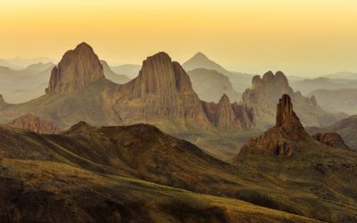
Beyond the plateau lies the Sahara Desert, covering more than four-fifths of Algeria’s territory. The Sahara’s vast dunes, rocky plateaus, and salt flats define the southern landscape and challenge settlement but are home to important desert towns such as Tamanrasset and Illizi. The mountain ranges, including the Hoggar Mountains and the Tassili n’Addar region in the south, add to the diverse topography with dramatic elevations and distinctive geological features.
Overall, Algeria’s topography and landscape are marked by a transition from lush Mediterranean coasts to expansive arid deserts, creating a map that reflects its complex geographical features and influences the distribution of its cities and regions.
Major Regions of Algeria
Algeria is a vast country with diverse landscapes and cultural regions, each contributing to its rich heritage. Its major regions include the Tell Atlas in the north, the Saharan Desert in the south, the High Plateaus in the central part, and the Tellian Mountains that run along the coast. These regions are home to important cities and towns, shaping the country’s geographical and cultural identity. Understanding these regions is essential when exploring an Algeria map with cities, as it provides insight into the country’s varied terrain and regional characteristics.
Tell Atlas Mountains
The Tell Atlas Mountains are a major mountain range that runs along the northern coast of Algeria, forming a significant geographic feature of the country. These mountains extend from the border with Morocco in the west to the border with Tunisia in the east, separating the coastal plains from the interior plateaus and desert regions. The range is known for its lush vegetation, diverse climate, and vital role in Algeria’s agriculture and water resources. Major cities such as Algiers, Algeria’s capital, are nestled in the foothills of the Tell Atlas, making it a central area in the country’s map with cities. The mountain range also influences the climate, with wetter conditions on the northern slopes supporting forests and farmland, contrasting with the arid regions beyond. The Tell Atlas is a crucial part of Algeria’s natural landscape and cultural history, shaping the development and settlement patterns across the northern part of the country.
Saharan Desert
Algeria is a vast country characterized by diverse regions, each with unique geographic features. The major regions include the Tell Atlas in the north, the Kabylie mountains, the High Plateaus, and the Saharan Desert in the south. The Saharan Desert, covering more than four-fifths of the country’s territory, is a striking arid region known for its expansive dunes, rocky plateaus, and unique desert landscapes. Cities like Tamanrasset, Djanet, and Ouargla serve as key gateways to the desert, offering insights into the life and culture of the nomadic and desert communities. The Sahara’s vastness and distinct environment play a significant role in Algeria’s overall geography, making it a prominent feature on the Algeria map with notable cities located within or near its boundaries.
Coastal Plains
The coastal plains of Algeria are a significant geographical region that stretch along the Mediterranean Sea, providing a fertile and densely populated area. These plains are characterized by their relatively flat terrain, Mediterranean climate, and rich agricultural lands, making them important for settlements and economic activities.
- Tell Atlas: The northernmost part of the coastal plains, encompassing cities like Algiers, the capital of Algeria, along with Oran, Blida, and Boumerdes. This area is known for its vibrant urban centers and port activities.
- Sahara Coastal Zone: Although primarily desert, this region includes important ports and towns such as Ghardaia and Bechar, serving as gateways between the desert interior and the Mediterranean.
- Algiers Plain: Centered around Algiers, this plain features a concentration of political, economic, and cultural sites with a dense network of roads and infrastructure.
- Western and Eastern Coastal Plains: These extend along the coast towards areas like Annaba and Skikda, known for industrial zones, fisheries, and historical sites.
Key Cities in Algeria
Algeria, a vast North African country, is home to several key cities that serve as cultural, economic, and historical hubs. These cities are vital to understanding the country’s diverse landscape and dynamic society. From bustling urban centers to historic sites, the key cities in Algeria offer a glimpse into the nation’s rich heritage and modern development.
Algiers
Algiers is the capital and largest city of Algeria, serving as the political, economic, and cultural center of the country. Located along the Mediterranean coast, it features a mix of modern and historic architecture, with notable sites such as the Casbah, a UNESCO World Heritage site. Algiers is also a key port and commercial hub, contributing significantly to Algeria’s economy. Other important cities include Oran, known for its vibrant music scene and port activities, and Constantine, renowned for its dramatic bridges and ancient ruins. Annaba, situated in the northeastern part of the country, is vital for its industry and port facilities. These cities, among others, form the backbone of Algeria’s urban landscape and are integral to the nation’s map of key locations.
Oran
Oran is one of the key cities in Algeria, situated along the Mediterranean coast. It is the second-largest city in the country and serves as an important cultural and economic hub. Known for its vibrant music scene, historic architecture, and busy port, Oran plays a significant role in Algeria’s maritime trade and industry. The city also boasts a rich history influenced by French, Spanish, and Ottoman cultures, reflected in its diverse architecture and cultural sites. As a major urban center, Oran is a vital part of the country’s overall map of key cities, contributing to Algeria’s development and regional importance.
Constantine
Constantine is one of the most significant cities in Algeria, known for its rich history and stunning architecture. Located in northeastern Algeria, it is often referred to as the “City of Bridges” due to its numerous bridges connecting the city across deep gorges. Constantine serves as a major cultural, industrial, and educational hub in the country.
- Algiers – The capital city and largest urban center of Algeria, known for its historic Casbah and vibrant markets.
- Oran – A coastal city famous for its nightlife, music, and beautiful Mediterranean beaches.
- Constantine – An ancient city perched on high plateaus, famous for its dramatic bridges and historic sites.
- Annaba – A port city with a rich Roman history, situated along the Mediterranean coast.
- Blida – Located near the Tell Atlas mountains, known for its lush gardens and agricultural activity.
- Sétif – An important economic and cultural center in the northeast, recognized for its archaeological sites.
- Tlemcen – A city renowned for its Islamic architecture, ancient mosques, and vibrant culture.
This list highlights some of the key cities across Algeria, each contributing uniquely to the country’s diverse landscape reflected on the Algeria map.
Annaba
Annaba is one of the key cities in Algeria, located in the northeastern part of the country along the Mediterranean coast. It is renowned for its vibrant port, which is one of the largest in Algeria, facilitating significant trade and economic activity. The city also boasts rich historical and cultural heritage, with landmarks such as the Basilica of Saint Augustine and ancient Roman ruins. As a major economic hub, Annaba plays a vital role in Algeria’s industry, especially in steel and heavy manufacturing sectors. Its strategic location and economic importance make it an essential city on the Algeria map with cities.
Blida
Blida is a significant city in Algeria located in the northern part of the country. It is known for its rich history, beautiful landscapes, and agricultural productivity. Situated near the Tell Atlas mountains, Blida offers a blend of natural beauty and cultural heritage, making it an important regional center.
- Algiers – The capital city of Algeria and the largest urban center, known for its Ottoman, French, and modern architecture.
- Oran – A major port city on the Mediterranean coast, famous for its vibrant culture and music scene.
- Constantine – Known as the city of bridges, it boasts a dramatic setting atop deep gorges and has a rich history dating back to ancient times.
- Annaba – An important port city in northeastern Algeria, recognized for its Roman history and beautiful beaches.
- Blida – Located south of Algiers, it is renowned for its gardens, such as the Botanical Garden of Rosemary, and its agricultural importance.
Algeria’s Capital: Algiers
Algiers, the bustling capital of Algeria, is a vibrant city rich in history and culture. Located along the Mediterranean coast, it serves as the political and economic center of the country. With its blend of historic landmarks and modern architecture, Algiers offers a unique glimpse into Algeria’s diverse heritage. Exploring the map of Algeria reveals the strategic importance of Algiers among its other cities and regions.
Location and Significance
Algiers, the capital of Algeria, is located along the Mediterranean coast in the northern part of the country. It serves as the political, economic, and cultural center of Algeria, playing a crucial role in the nation’s development. The city is known for its historic Ottoman and French colonial architecture, bustling markets, and vibrant nightlife. Strategically positioned, Algiers acts as a gateway for maritime trade and connects Algeria to other Mediterranean countries. Its significance extends beyond geography, as it symbolizes the nation’s identity and resilience, making it a key hub on the map of Algeria’s cities and regions.
Districts and Neighborhoods
Algiers, the capital city of Algeria, is a vibrant metropolis that blends modernity with rich history. It is situated along the Mediterranean coast, serving as the political, economic, and cultural hub of the country. The city is divided into numerous districts and neighborhoods, each offering a unique character and atmosphere.
Algiers is composed of several main districts, including the Casbah, which is a UNESCO World Heritage site known for its narrow, winding streets and historic buildings. The modern districts like El Harrach and Hydra are home to government offices, businesses, and upscale residences. Other notable neighborhoods include Bab El Oued, a lively area filled with markets and cafes, and Belouizdad, which hosts residential communities and educational institutions.
Each district and neighborhood in Algiers contributes to the city’s diverse landscape, making it a city of contrasts where ancient architecture coexists with modern urban development. Exploring the map of Algeria with cities will reveal Algiers as a central feature, highlighting its significance and the distinct urban areas within the city.
Major Landmarks
Algiers, the capital of Algeria, is a vibrant city known for its rich history and diverse architecture. It is situated along the Mediterranean coast and serves as the political, economic, and cultural center of the country.
Major landmarks in Algiers include the historic Kasbah, a UNESCO World Heritage site featuring narrow winding streets and traditional Islamic architecture. The Martyrs’ Memorial stands as a prominent monument honoring those who fought for independence. The Great Mosque of Algiers, one of the largest mosques in Africa, showcases stunning Islamic design and houses a large prayer hall. The Bardo Museum offers insights into Algeria’s ancient history and cultural heritage. Additionally, the Jardin d’Essai and the seaside promenades provide scenic spots for relaxation and leisure, making Algiers a city full of historical landmarks and modern attractions.
Regional Cities and Their Features
Regional cities in Algeria are vibrant centers of culture, commerce, and history, each offering unique features that contribute to the country’s diverse landscape. These cities play a crucial role in shaping regional identities and fostering economic growth. Understanding their distinct characteristics provides valuable insights into Algeria’s overall geographic and cultural fabric.
Oran: The Western Gateway
Oran, known as the Western Gateway of Algeria, is a vibrant regional city that plays a significant role in the country’s economic and cultural landscape. Located along the Mediterranean coast, Oran boasts a rich history influenced by various civilizations, including Phoenician, Roman, and Ottoman eras. Its strategic position makes it a crucial port city, facilitating trade and commerce in the region.
The city is renowned for its unique blend of modernity and tradition, featuring impressive architecture, lively markets, and cultural festivals. Oran is also famous for its musical heritage, especially Raï music, which originated there and symbolizes the city’s lively spirit. The city’s robust infrastructure includes bustling ports, transportation networks, and educational institutions, making it an important hub in western Algeria.
As a regional center, Oran offers diverse attractions, from beautiful beaches along the Mediterranean to historic sites such as the Santa Cruz fortress. Its dynamic economy is driven by industries like shipping, manufacturing, and tourism. Overall, Oran’s strategic location, cultural richness, and economic vitality establish it as a vital regional city and the Western Gateway in Algeria’s map of cities.
Constantine: The City of Bridges
Constantine, often referred to as the “City of Bridges,” is one of Algeria’s most historically significant regional cities. Located in northeastern Algeria, it is renowned for its dramatic setting atop a series of deep gorges and rugged cliffs, which are connected by numerous bridges that showcase impressive engineering feats. These bridges, including the famous Sidi M’Cid Bridge, symbolize the city’s resilience and ingenuity. Constantine’s rich history dates back to ancient times, evident in its archaeological sites, old medina, and Ottoman architecture. The city functions as a cultural, educational, and economic hub in the region, attracting visitors with its unique landscape and vibrant heritage. Its strategic position and historical significance make it a vital part of Algeria’s diverse regional landscape, contributing to the country’s overall identity and development.
Annaba: The Port City
Annaba is a significant regional city in Algeria, renowned for its vibrant port and rich history. Located in the northeastern part of the country along the Mediterranean coast, Annaba serves as a vital economic hub and cultural center. Its strategic position contributes to extensive maritime trade and connectivity within Algeria and beyond.
- Port City: Annaba’s port is one of the largest in Algeria, facilitating the import and export of goods, including minerals, machinery, and agricultural products.
- Historical Heritage: The city boasts historical sites such as the ancient Roman ruins of Hippo Regius, reflecting its long-standing significance through the ages.
- Industrial Center: Annaba is known for its heavy industries, including steel production and petrochemical plants, which contribute heavily to the national economy.
- Natural Features: Surrounded by hills and scenic landscapes, the city offers picturesque views and outdoor recreational opportunities.
- Cultural Diversity: Annaba hosts a mix of cultural influences, with vibrant festivals, markets, and a lively local arts scene that showcase its diverse heritage.
Setif and Skikda: Industrial Centers
Setif and Skikda are notable regional cities in Algeria, each distinguished as important industrial centers. Setif is renowned for its vibrant agricultural sector and diverse manufacturing industries, including textiles, food processing, and construction materials. It benefits from a strategic location that facilitates trade and economic development within the region. Skikda, on the other hand, is a major port city with a strong industrial base centered around petrochemicals, oil refining, and heavy industries. Its port infrastructure supports the export of hydrocarbons and industrial goods, making it a vital hub for Algeria’s energy sector. Together, these cities exemplify Algeria’s diverse economic landscape and regional industrial strengths, playing key roles on the country’s map as centers of growth and industrial activity.
Map Details and Geographical Boundaries
The Algeria map with cities offers a detailed view of the country’s geographical layout, highlighting key locations and boundaries. Understanding the map details and geographical boundaries provides valuable insights into Algeria’s diverse landscape, regional divisions, and urban centers. This knowledge enhances navigation, planning, and appreciation of Algeria’s rich cultural and natural features.
Official Administrative Divisions
The map of Algeria with cities provides detailed information about the country’s geographical boundaries and administrative divisions. It highlights the precise borders that separate Algeria from neighboring countries such as Tunisia, Libya, Niger, Mali, Mauritania, Western Sahara, and Morocco. These boundaries are clearly defined to reflect both natural and political borders, ensuring an accurate representation of the nation’s territorial extent.
Algeria is divided into multiple official administrative divisions, including provinces (wilayas), districts, and municipalities. The country consists of 58 provinces, each governed by a local administrative authority. Major cities such as Algiers, Oran, Constantine, and Annaba serve as administrative centers within their respective regions. The map details city locations within these divisions, emphasizing their roles in regional administration and connectivity.
Overall, the map provides a comprehensive view of Algeria’s geographical boundaries and administrative structure, aiding in understanding the spatial organization of the country and the distribution of its urban centers. It serves as a valuable resource for navigation, education, and geographical analysis of Algeria.
Provinces (Wilayas) and Their Capitals
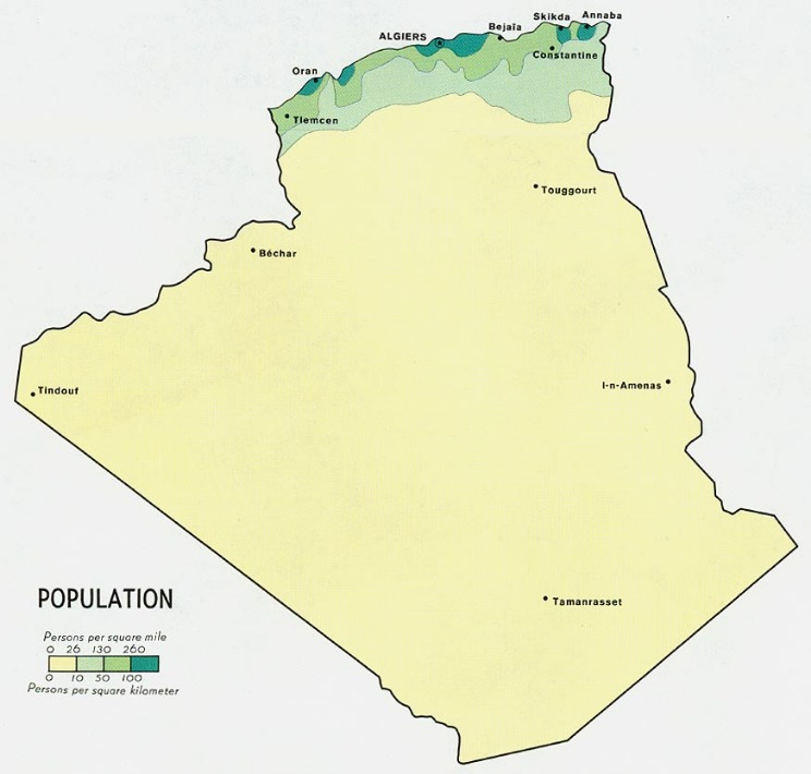
An Algeria map with cities provides a comprehensive view of the country’s geographical boundaries and important urban centers. It highlights the diverse landscape, from the Sahara Desert in the south to the Atlas Mountains in the north, capturing the overall physical geography of the nation. The map also illustrates the division of Algeria into its various provinces, known locally as Wilayas, each with its own administrative capital. These Wilayas serve as key administrative regions that facilitate local governance and organization.
Algeria is divided into 58 Wilayas, each with a designated capital city. For example, Algiers is the capital of the Algiers Wilaya, serving as the political, economic, and cultural hub of the country. Other important Wilayas include Oran, the capital of the Oran Wilaya, and Constantine, the capital of the Constantine Wilaya. The map clearly marks these capitals, helping users understand the administrative structure and geographic distribution of Algeria’s major urban centers.
Overall, detailed Algeria maps with city markers and provincial boundaries are valuable resources for understanding the country’s administrative layout, regional distinctions, and geographic characteristics. They are essential for travelers, researchers, and anyone interested in exploring or studying Algeria’s regional diversity and urban development.
Map Scale and Key Features
Algeria’s map provides detailed information about its geographical boundaries, showcasing the extent of the country’s territory in North Africa. The map clearly delineates the borders with neighboring countries such as Tunisia, Libya, Niger, Mali, Mauritania, Western Sahara, and Morocco. Major cities like Algiers, Oran, Constantine, and Annaba are prominently marked, giving a sense of the urban distribution across the nation. The map scale is designed to balance detail with readability, typically representing a certain distance on the map corresponding to actual kilometers or miles. This allows users to estimate distances between key locations accurately. Key features highlighted on the map include mountain ranges like the Atlas Mountains, the Sahara Desert covering a large part of the south, coastal areas along the Mediterranean Sea, and significant rivers and valleys. Such details facilitate better understanding of Algeria’s diverse landscape and geographical layout, making it a valuable resource for visitors, researchers, and students interested in exploring the country’s physical and political geography.
User Navigation and Map Usage Tips
Exploring the Algeria map with cities becomes easier with effective user navigation and map usage tips. Understanding how to navigate the map allows you to find specific cities quickly and efficiently, making your experience more enjoyable. Whether you’re planning a trip or studying regional distributions, mastering these navigation techniques will enhance your comprehension of Algeria’s geography.
Interpreting Algeria’s Map Features
Understanding Algeria’s map features and utilizing the navigation tools effectively can greatly enhance your exploration experience. When interpreting the map, pay attention to key symbols and color codes that represent cities, roads, landmarks, and geographic features, making it easier to plan your routes and identify points of interest. Use zoom functions to get detailed views of specific areas, such as major cities like Algiers, Oran, and Annaba, or to gain a broader perspective of the country’s vast landscape. Interactive maps often include labels and legends—review these carefully to familiarize yourself with the map’s symbols. When navigating between cities, consider the main highways and transportation routes marked on the map to optimize travel efficiency. Additionally, pay close attention to elevation contours and natural features such as deserts, mountains, and coastlines for better understanding of Algeria’s geography. Utilizing map tools like search functions and landmarks can save time and help locate specific destinations within the country more precisely.
How to Locate Major Cities
When exploring an Algeria map, navigating effectively and locating major cities can enhance your understanding of the region. Familiarizing yourself with navigation tips and map usage will make your experience more efficient and enjoyable.
- Begin by identifying the map’s key features such as borders, coastlines, and landmarks to orient yourself.
- Use the map’s legend to understand symbols representing cities, roads, and other important points.
- Look for the larger, bolded city names which typically indicate major urban centers like Algiers, Oran, Constantine, and Annaba.
- Utilize scale markers to estimate distances between cities, helping you plan routes effectively.
- If available, use latitude and longitude lines to precisely locate major cities on the grid.
- Practice identifying major cities by their relative positions: for example, Algiers is on the northern coast, while Tamanrasset is in the southern desert region.
- Zoom in on detailed sections of the map for smaller cities, and zoom out for an overall view of the country’s layout.
- Consult online maps or digital tools if you need more interactive and detailed navigation options.
Understanding Geographic and Political Boundaries
When exploring the Algeria map with cities, effective user navigation and map usage are essential for a seamless experience. Familiarize yourself with the zoom controls to easily focus on specific regions or cities. Use the search feature to quickly locate major cities like Algiers, Oran, and Constantine. Understanding the geographic boundaries helps in grasping the spatial relationships between different areas of the country. Recognize the political boundaries that separate provinces and regions, which are often marked distinctly on the map. This knowledge allows for better planning, whether for travel, study, or geographic analysis. Additionally, interpret the map’s legend to understand symbols and color codes representing various landmarks, transportation routes, and administrative boundaries, ensuring accurate comprehension of Algeria’s diverse landscape.


0 Comments