Geographical Overview of Mauritius
Located in the Indian Ocean, Mauritius is a picturesque island nation known for its diverse landscapes and rich cultural heritage. Surrounded by crystal-clear waters, the island features lush mountains, rolling plains, and extensive coral reefs, making it a unique geographical marvel. Its strategic position and varied terrain contribute to its vibrant ecosystems and appealing scenery, offering a fascinating subject for map enthusiasts and travelers alike.
Location and Coordinates
Mauritius is an island nation located in the Indian Ocean, east of the continent of Africa. It is part of the Mascarene Islands, along with Réunion and Rodrigues. The country is situated approximately 2,000 kilometers (around 1,240 miles) southeast of the coast of Africa. The geographical coordinates of Mauritius are roughly 20.3 degrees south latitude and 57.5 degrees east longitude, placing it well within the southern hemisphere. Its strategic location in the Indian Ocean has historically made it an important hub for maritime trade and cultural exchanges.
Topography and Landscape Features
Mauritius is an island nation located in the Indian Ocean, east of the coast of Africa. Its geographical landscape is characterized by a diverse topography that combines lush green mountains, volcanic plateaus, and beautiful beaches. The island’s terrain is largely volcanic in origin, with the central massif, including the prominent Piton de la Petite Rivière Noire, reaching elevations of over 800 meters. Surrounding this central highland are fertile plains and coastal areas that host the island’s vibrant coral reefs and sandy beaches. The landscape features include rugged mountains, rolling hills, and coastal lagoons, creating a picturesque and varied environment suitable for agriculture, tourism, and natural reserves. The island’s strategic location and volcanic origins have given rise to a unique landscape that combines natural beauty with ecological diversity, making Mauritius a popular destination for nature lovers and travelers seeking diverse scenery.
Climate and Weather Patterns
Mauritius is an island nation situated in the Indian Ocean, approximately 2,000 kilometers off the southeastern coast of Africa. It is part of the Mascarene Islands alongside Réunion and Rodrigues. The island features a diverse topography that includes volcanic mountains, lush green valleys, and expansive beaches lining its coastlines. The central plateau is characterized by volcanic formations and fertile plains, while the southern and eastern parts are more rugged and hilly. The surrounding waters are rich in coral reefs, supporting vibrant marine life.
The climate of Mauritius is tropical, with relatively warm temperatures year-round. It experiences a mild and dry winter from June to September, with temperatures ranging from 17°C to 23°C, and a hot, humid summer from December to April, with temperatures often reaching 30°C or higher. The island also faces a cyclone season typically from January to March, which can bring heavy rainfall and strong winds. Rainfall is distributed unevenly across the island, with the northeast receiving more precipitation due to trade winds, contributing to the lushness of the region. Overall, the climate fosters diverse ecosystems and makes Mauritius a popular destination for beach tourism and water-based activities.
Regions and Districts of Mauritius
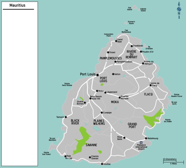
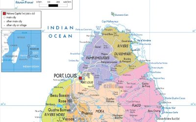
The map of Mauritius showcases the diverse regions and districts that make up this beautiful island nation. Each district offers unique cultural, geographical, and historical features, contributing to the rich tapestry of Mauritius. Understanding these divisions helps visitors and residents alike navigate and appreciate the island’s vibrant landscape.
North Region
The North Region of Mauritius is one of the most popular and vibrant areas on the island, known for its beautiful beaches, lively towns, and cultural attractions. It includes districts such as Pamplemousses, and Rivière du Rempart, offering a mix of historical sites, botanical gardens, and stunning coastal scenery. This region is a key destination for both tourists and residents, providing a variety of amenities and entertainment options. The map of Mauritius highlights the North as a prominent area with picturesque landscapes, bustling markets, and iconic landmarks like the Trou aux Biches and Grand Baie.
South Region
The South Region of Mauritius is known for its diverse landscapes and vibrant communities. It includes several districts that each offer unique cultural and natural attractions. This region is situated at the southern part of the island and features notable sites such as Le Morne Brabant and Black River Gorges National Park. The districts within the South Region include Black River, Grand Port, and Savanne. Black River is famous for its beautiful beaches, waterfalls, and surfing spots. Grand Port is renowned for its historic port and archaeological sites, reflecting the island’s colonial past. Savanne offers lush forests, scenic hiking trails, and a peaceful rural environment. Together, these districts make the South Region a popular destination for tourists and a vital part of Mauritius’s diverse geographic and cultural landscape.
East Region
The East Region of Mauritius is known for its beautiful coastal areas and vibrant communities. It is comprised of several districts, each offering unique attractions and landscapes. The region is renowned for its stunning beaches, lagoons, and historical sites, making it a popular destination for tourists and locals alike.
In the East Region, districts such as Flacq, Mahébourg, and Grand Port are prominent. Flacq is famous for its expansive shopping centers and lively markets, while Mahébourg boasts rich historical significance with its colonial architecture and former naval base. Grand Port district includes the serene beaches and the historic town of Mahebourg, which reflects the island’s maritime history.
Overall, the East Region of Mauritius combines natural beauty with cultural heritage, contributing to the diverse landscape of the island as shown on the map of Mauritius. Visitors can explore white sandy beaches, coral reefs, and traditional villages, making it a vibrant part of the island’s geographical and cultural map.
West Region
The West Region of Mauritius is a vibrant and diverse area, known for its scenic landscapes, beaches, and cultural sites. It comprises several districts that each offer unique attractions and experiences for visitors and residents alike.
- Black River District: Famous for its stunning beaches, including Tamarin Bay and Flic en Flac, as well as the Black River Gorges National Park, which offers hiking trails and waterfalls.
- Ile aux Cerfs District (part of Flacq): Known for the popular island of Ile aux Cerfs, a paradise for water sports and leisure activities.
- Rivière Noire District: Hosts the bustling town of Curepipe and Quatre Bornes, with shopping, markets, and cultural sites.
- Port Louis District: Contains the capital city, Port Louis, offering historical monuments, markets, and vibrant nightlife.
Central Plateau
The Central Plateau of Mauritius is a prominent region known for its elevated terrain and lush landscapes. It is situated at the heart of the island and encompasses several key districts that contribute to the area’s cultural and economic significance. The region is characterized by cooler temperatures and scenic vistas, making it a popular destination for both locals and tourists.
The main districts within the Central Plateau include Curepipe, Quatre Bornes, and Plaine Magnien. Curepipe is renowned for its cooler climate and colonial architecture, serving as a major administrative and commercial hub. Quatre Bornes is known for its vibrant markets and lively street life, often referred to as the “City of Flowers.” Plaine Magnien is a more rural district that offers picturesque views and is important for agriculture.
These districts are interconnected through a network of roads and are part of the broader map of Mauritius, which showcases the diverse regions of this beautiful island. The Central Plateau bridges the southern and northern parts of Mauritius, making it a crucial area for transportation and regional development.
Main Cities and Urban Areas
Main cities and urban areas are vital centers of culture, commerce, and innovation. They serve as the heartbeat of a country’s development and often reflect its history, diversity, and growth. In the context of Mauritius, understanding its main urban areas provides valuable insights into the nation’s geography and lifestyle, contributing to a comprehensive view of what makes this island unique.
Port Louis
Port Louis is the capital city and the largest urban area of Mauritius, serving as the economic, political, and cultural hub of the island nation. Located on the northwest coast, it is a vibrant city known for its bustling markets, historic sites, and modern infrastructure. As a main city, Port Louis plays a key role in the growth and development of Mauritius, attracting both local residents and international visitors.
Grand Baie
Grand Baie is one of the main cities and popular urban areas in Mauritius, renowned for its vibrant tourism scene and lively nightlife. Located on the north coast of the island, it serves as a key hub for visitors seeking beaches, water sports, and shopping experiences. As a bustling town, Grand Baie contributes significantly to the economic and cultural landscape of Mauritius.
Quatre Bornes
Quatre Bornes is one of the main cities and urban areas in Mauritius, known for its vibrant community and dynamic commercial activities. It is situated in the western part of the island and serves as a bustling hub for shopping, entertainment, and cultural events. The city is characterized by busy markets, modern shopping malls, and various recreational facilities that attract both locals and visitors. As a key urban area, Quatre Bornes plays a significant role in the overall urban landscape of Mauritius, contributing to the economic and social development of the island.
Curepipe
Curepipe is one of the main cities and urban areas in Mauritius, known for its pleasant climate and vibrant community. It serves as a key commercial and residential hub on the island, attracting residents and visitors alike.
- Located inland, Curepipe is approximately 20 kilometers southeast of Port Louis, the capital city of Mauritius.
- It is renowned for its cooler climate compared to the coastal regions, making it a popular retreat during hot weather.
- The city boasts various shopping centers, restaurants, and cultural sites, contributing to its lively urban atmosphere.
- As part of Mauritius’s map, Curepipe plays a significant role in the island’s infrastructure and economy, connecting different regions through road networks.
Natural Landmarks and Sites of Interest
Discovering the natural landmarks and sites of interest in Mauritius offers a breathtaking glimpse into the island’s diverse landscape and rich heritage. From lush mountains to pristine beaches, each location showcases the unique beauty that makes Mauritius a sought-after destination for travelers seeking natural wonders. Exploring these sites provides an unforgettable experience and deepens appreciation for the island’s remarkable environment.
Black River Gorges National Park
Black River Gorges National Park is a prominent natural landmark located in the southwest of Mauritius. Covering approximately 65 square kilometers, it is a protected area that showcases the island’s rich biodiversity and stunning landscapes. Visitors can explore lush forests, panoramic viewpoints, waterfalls, and endemic plant and animal species that are unique to the island. The park is an ideal destination for hiking, bird watching, and experiencing the pristine natural environment of Mauritius.
Le Morne Brabant
Le Morne Brabant is a striking natural landmark and a UNESCO World Heritage Site located on the southwest coast of Mauritius. This imposing mountain is renowned for its cultural significance and breathtaking scenery, attracting visitors from around the world. It stands as a symbol of the island’s history, especially related to the emancipation of runaway slaves who sought refuge on its summit to escape colonial oppression.
The site offers spectacular panoramic views of the surrounding ocean and lush landscape, making it a popular destination for hiking, nature walks, and photography. Its unique limestone cliffs and verdant surroundings highlight Mauritius’s diverse natural beauty. Le Morne Brabant is not only a natural wonder but also a poignant reminder of the island’s cultural heritage and resilience.
Chamarel Waterfall and Rainbow Mountain
Mahreu on the beautiful island of Mauritius offers a variety of natural landmarks and sites of interest that attract visitors from around the world. Among these, the Chamarel Waterfall and Rainbow Mountain stand out as must-see destinations for nature enthusiasts and adventure seekers alike.
- Chamarel Waterfall: Located in the southwest of Mauritius, Chamarel Waterfall is one of the most spectacular waterfalls on the island. It cascades from a height of about 83 meters into a lush green gorge, creating a breathtaking view. Surrounded by vibrant plant life and overlooking the South West Nature Reserve, this waterfall offers excellent photo opportunities and a tranquil atmosphere for visitors.
- Rainbow Mountain (Le Morne Brabant): While commonly known as Le Morne Brabant, a UNESCO World Heritage Site, Rainbow Mountain is celebrated for its striking colors and panoramic scenery. This mountain is famous for its multi-colored volcanic slopes, which showcase a natural spectrum of reds, yellows, and greens. It is also a significant cultural site, symbolizing the history and resilience of the enslaved people who once sought refuge here. Hiking to the summit provides stunning views of the island and the Indian Ocean.
Île aux Cerfs and Other Islands
Mauritius is renowned for its stunning natural landmarks and picturesque islands, making it a popular destination for travelers seeking scenic beauty and outdoor adventures.
One of the most famous natural sites is the Île aux Cerfs, a small island located off the east coast of Mauritius. It is celebrated for its pristine white sandy beaches, clear lagoons, and vibrant coral reefs, perfect for snorkeling, swimming, and relaxing. The island also features a golf course and various water sports activities, attracting visitors from around the world.
Beyond Île aux Cerfs, Mauritius is home to other beautiful islands and sites of interest. Île aux Aigrettes is a protected nature reserve rich in endemic flora and fauna, offering a glimpse into the island’s natural heritage. Île aux Serpents, although notable for its name, is known more for its wildlife and conservation efforts.
The island’s diverse landscapes include the Black River Gorges National Park, marked by lush rainforests, waterfalls, and hiking trails, and the Le Morne Brabant, a UNESCO World Heritage Site with a striking mountain backdrop. These natural landmarks highlight Mauritius’s rich ecological and geological diversity, making the island a truly remarkable destination for nature lovers.
Transportation Networks
Transportation networks are vital for connecting different regions and facilitating the movement of people and goods. In the context of Mauritius, these networks play a crucial role in linking urban areas, rural communities, and key tourist destinations across the island. A well-developed transportation system enhances accessibility, supports economic growth, and promotes tourism, making it an essential aspect of the island’s infrastructure.
Roads and Highways
Transportation networks, roads, and highways are vital components of Mauritius’s infrastructure, facilitating the movement of people and goods across the island. The map of Mauritius highlights a well-developed system that connects urban centers with rural areas, ensuring accessibility and economic growth.
- Primarily, the main highways and roads are designed to support efficient travel between major cities such as Port Louis, Curepipe, and Quatre Bornes.
- Major highways like the M1, M2, and M3 provide vital links across the island, reducing travel time and improving connectivity.
- Secondary roads and local streets extend from these main routes, enabling access to remote villages and tourist destinations.
- The road network is complemented by public transportation options, including buses and shared taxis, which are prominently featured on the map of Mauritius.
- Recent developments aim to expand and upgrade the road infrastructure to cope with increasing traffic and urbanization.
Public Transit Systems
Transportation networks and public transit systems play a vital role in the development and connectivity of Mauritius. The island features a comprehensive road network that facilitates movement across urban and rural areas, supported by well-maintained highways and secondary roads. Public transit options primarily include buses operated by the National Transport Authority, which connect major towns, tourist destinations, and suburbs. These systems provide affordable and accessible transportation for residents and visitors alike. Additionally, there are plans to enhance the transportation infrastructure with proposals for modernized transit solutions, including potential metro or light rail projects, aiming to improve efficiency and reduce traffic congestion. The Mauritius map often highlights these transit routes, showcasing the integration of road networks and public transit systems to support the island’s economic growth and mobility needs.
Ports and Airports
Transportation networks, including ports and airports, are vital components of Mauritius’s infrastructure, facilitating both domestic connectivity and international trade. The island nation boasts a well-developed port system, with Port Louis being the main port serving as a hub for cargo shipping and logistics. This port handles a significant portion of the country’s imports and exports, making it essential for economic activities. Additionally, Mauritius features an international airport, Sir Seewoosagur Ramgoolam International Airport, which connects the island to major destinations across Africa, Europe, Asia, and beyond. The air transport network supports tourism, business travel, and cargo transportation, playing a crucial role in the island’s economy. Overall, the integrated transportation infrastructure of ports and airports enhances Mauritius’s connectivity, supporting its growth as a key regional hub.
Maps and Cartography in Mauritius
Maps and cartography in Mauritius hold a vital place in the island’s history and development. The art of mapmaking has evolved over centuries, reflecting the island’s rich cultural heritage and geographical significance. From early explorers to modern digital cartography, Mauritius has witnessed remarkable advancements that enhance navigation, land management, and geographical understanding on the island.
Historical Maps and Evolution
Maps and cartography in Mauritius have a rich history that reflects the island’s strategic importance and evolving understanding of its geography. Historically, early maps of Mauritius were created by explorers and sailors who documented the island’s coastline and notable landmarks as they navigated the Indian Ocean. These maps were often rudimentary, illustrating the island’s position relative to trade routes and nearby landmasses. Over time, as European powers such as the Dutch, French, and British took control of Mauritius, more detailed and accurate cartographic representations were produced, incorporating land features, sugar plantations, and settlements. The evolution of map-making techniques, from hand-drawn charts to modern digital cartography, has significantly enhanced the accuracy and utility of maps. Today, geographic information systems (GIS) and satellite imagery provide precise, dynamic maps that support development, navigation, and environmental management. The history of maps in Mauritius showcases a progression from simple navigational sketches to sophisticated representations that reflect the island’s cultural and geographical complexity. This journey highlights the importance of cartography in both understanding and shaping the development of Mauritius as a nation and a key maritime hub.
Modern Digital Mapping Technologies
Maps and cartography in Mauritius have a rich history that reflects the island’s evolving understanding of its geography, from traditional hydrography to modern digital mapping technologies. Today, digital mapping plays a vital role in various sectors, including urban planning, tourism, and environmental management. Modern digital mapping technologies such as Geographic Information Systems (GIS), satellite imagery, and drone surveying enable precise and up-to-date representations of Mauritius’s diverse landscapes. These tools facilitate detailed spatial analysis, helping policymakers and developers make informed decisions. Additionally, open-source mapping platforms like OpenStreetMap allow for community-driven map updates, ensuring local relevance and accuracy. The integration of these advanced technologies continues to enhance the quality and accessibility of maps of Mauritius, supporting sustainable development and tourism growth on the island.
Uses of Maps for Tourism and Navigation
Maps and cartography play a vital role in Mauritius by providing detailed representations of the island’s geography, facilitating navigation, planning, and exploration. Mauritian maps help in understanding the diverse landscapes, from sandy beaches to mountainous regions, aiding both locals and visitors in navigation and decision-making. Cartography services contribute to urban planning, infrastructure development, and environmental management, ensuring sustainable growth on the island. The precision of maps supports various sectors such as agriculture, tourism, and transport, enhancing overall efficiency and safety.
In tourism, maps serve as essential tools for visitors to explore Mauritius’s popular destinations, beaches, national parks, and cultural sites. Tourist maps often highlight points of interest, accommodations, and routes, making it easier for travelers to plan their trips. Digital maps and GPS applications provide real-time directions, ensuring smooth navigation across the island. For navigation, accurate maps assist drivers, hikers, and watercraft operators in reaching their destinations safely, preventing accidents and ensuring a enjoyable experience. Overall, maps and cartography significantly contribute to making Mauritius a welcoming and well-organized destination for visitors and residents alike.


0 Comments