.jpeg")
Geography of Mauritius
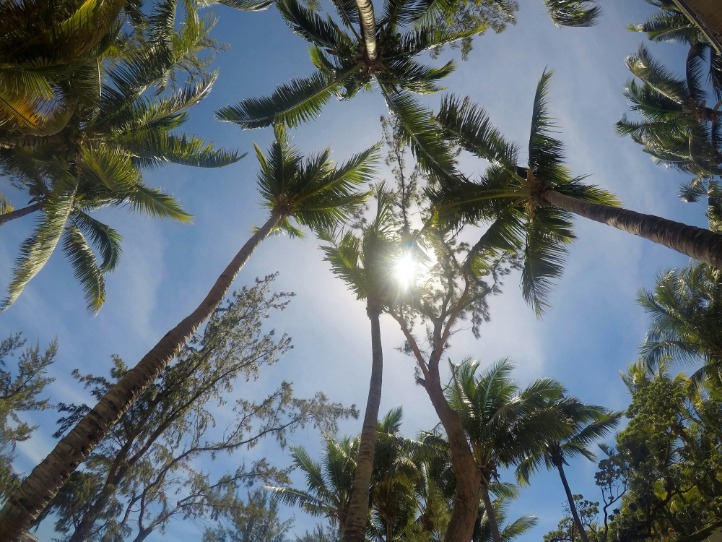
The island of Mauritius is a tropical paradise situated in the Indian Ocean, east of the continent of Africa. Known for its stunning landscapes, diverse terrain, and rich ecological heritage, Mauritius covers an area of approximately 2,040 square kilometers. Its geography includes lush volcanic mountains, expansive beaches, coral reefs, and fertile plains, making it a unique destination for nature lovers and explorers alike.
Location and Coordinates
The island of Mauritius is located in the Indian Ocean, off the southeastern coast of Africa. It is part of the Mascarene Islands, which also includes Réunion and Rodrigues. Mauritius is situated approximately 2,000 kilometers (1,200 miles) southeast of the coast of mainland Africa, near the Tropic of Capricorn.
The coordinates of Mauritius are approximately 20.3484° South latitude and 57.5522° East longitude. Its position in the southern Indian Ocean gives it a tropical climate and makes it a popular tourist destination. The island’s geography features a combination of sandy beaches, coral reefs, rugged volcanic mountains, and lush inland forests, all of which are clearly depicted on maps of Mauritius.
Topography and Terrain
Mauritius is a volcanic island located in the Indian Ocean, known for its diverse topography and rugged terrain. The island’s geography features a central plateau surrounded by mountain ranges and coastal plains. The terrain is characterized by lush green hills, volcanic mountains, and fertile valleys that support rich biodiversity and agriculture. Prominent peaks, such as Piton de la Petite Rivière Noire, stand majestically within the island’s interior, offering stunning views and contributing to the island’s scenic beauty. The coastal areas are generally flat and sandy, with coral reefs protecting the shores and making them ideal for tourism and marine activities. Overall, the topography of Mauritius combines volcanic origins with a variety of elevations and landscapes, creating a uniquely varied geographic profile.
Major Landforms
The island of Mauritius is known for its diverse geography and striking landforms that define its landscape. Situated in the Indian Ocean, this volcanic island features a variety of major landforms that contribute to its unique terrain and natural beauty.
- Volcanoes and volcanic peaks, including the prominent Le Morne Brabant and Pieter Both.
- Coral reefs surrounding the island, creating natural lagoons and protected marine areas.
- Mountain ranges with lush green hills and valleys, particularly in the central and southwestern regions.
- Plateaus such as Plaine Champagne and Plaine Verte, which are fertile for agriculture.
- Coastal cliffs and white sandy beaches along the island’s perimeter.
- Rivers and waterfalls that flow through the volcanic terrain, enhancing the island’s scenic beauty.
Climate and Weather Patterns
The island of Mauritius is situated in the Indian Ocean, east of the coast of Madagascar. It features a diverse geography with rugged mountains, lush valleys, and extensive coral reefs along its coastlines. The central plateau is characterized by fertile plains and volcanic formations, contributing to its rich biodiversity. The island’s landscape is dotted with inland rivers and waterfalls, making it a picturesque destination.
The climate of Mauritius is classified as a tropical island climate, with warm temperatures and high humidity throughout the year. It experiences distinct wet and dry seasons, with the summer months from November to April being hot and humid, often accompanied by heavy rainfall and cyclones. The winter months from June to September are cooler and drier, making it the best time to visit. The island’s weather patterns are influenced by monsoons and ocean currents, contributing to its moderate temperature variations and rainfall distribution across different regions.
Map Features of Mauritius
The map features of Mauritius showcase the island’s diverse geographical landscape, including its lush interior, rocky coastlines, and picturesque beaches. It highlights key areas such as capital cities, mountain ranges, and major roads, providing a comprehensive view of the island’s physical and political boundaries. Understanding these features helps visitors and residents navigate and appreciate the unique beauty and structure of Mauritius.
Main Islands and Atolls
The island of Mauritius and its surrounding atolls are characterized by diverse map features that highlight its unique geographic and marine environment. The main island is the largest landmass within the republic, featuring rugged mountains, lush valleys, and expansive beaches. Surrounding the main island are several smaller islands and atolls that add to the area’s geographic complexity and scenic beauty.
- Main Island Mauritius: The central focus, known for its mountainous terrain and coastal regions.
- Île aux Cerfs: A popular island renowned for its beaches and water sports.
- Coin de Mire (Gunners’ Quoin): An isolated volcanic islet famous for its cliffs and marine life.
- Île aux Aigrettes: A small coral reef island protected as a nature reserve.
- Rodrigues Island: Located east of Mauritius, known for its lagoons and eco-tourism sites.
- Îles aux Serpents and Île aux Benitiers: Smaller islands near the main island, popular for tourism and recreation.
- Atolls and coral reefs: Surrounding the main islands are vibrant coral atolls that serve as critical habitats for marine biodiversity.
Coastline and Beaches
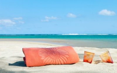
The island of Mauritius is renowned for its diverse and striking map features, including a rugged coastline and beautiful beaches. The coastline stretches approximately 177 kilometers, offering a variety of sandy shores, coral reefs, and rocky coves. These coastal areas are characterized by their vibrant marine life, making them popular spots for snorkeling, diving, and relaxing by the sea. The beaches of Mauritius, such as Belle Mare, Flic en Flac, and Grand Baie, are famous for their pristine white sands and crystal-clear waters. These scenic spots not only define the island’s natural beauty but also contribute significantly to its tourism appeal, providing picturesque landscapes and tranquil environments for visitors seeking leisure and adventure.
Mountain Ranges and Peaks
The island of Mauritius is characterized by diverse and prominent geographical features that make its map particularly interesting. The island’s central region is dominated by mountains and peaks, showcasing its rugged terrain. These mountains are part of the island’s volcanic origin, contributing to its lush landscapes. The most notable mountain range is the Plaine Champagne Range, which stretches across the central part of the island. Among the peaks, Pieter Both stands out as one of the highest, offering spectacular views and being a significant landmark. Other important peaks include Le Morne Brabant and Signal Mountain, each adding to the scenic and topographical diversity of Mauritius. These mountainous features not only shape the island’s landscape but also influence its climate, flora, and fauna, making them essential elements for understanding Mauritius’s geography.
Rivers and Water Bodies
The island of Mauritius is characterized by diverse map features, including a rugged coastline with numerous bays and indentations. Inland, the landscape transitions into lush hills and volcanic mountains, notably the Pieter Both and Le Morne Brabant. The island’s topography influences its water bodies, creating a network of rivers and lakes. Major rivers such as the Grand River South East, Grand River North West, and the Rivière du Poste flow across various parts of Mauritius, providing vital water resources and supporting agriculture. Additionally, there are several lagoons, coral reefs, and artificial reservoirs that serve as important water bodies around the island, contributing to its rich biodiversity and scenic beauty. These water features are essential for both ecological balance and tourism activities, making Mauritius a unique island with stunning natural water landscapes.
Administrative Divisions on the Map
The map of Mauritius provides a detailed overview of the country’s administrative divisions, which are essential for understanding its governance and regional organization. These divisions help categorize the island’s various areas, including districts and municipalities, allowing for better management and administrative functions. Exploring the map reveals how Mauritius is segmented to facilitate local administration, development, and resource allocation across the island.
District Boundaries
The map of Mauritius features clearly defined administrative divisions and district boundaries that help organize the island’s geographical and political landscape. These divisions facilitate local governance and administrative functions across the island. Each district is distinguished by its unique boundaries, often reflecting historical, geographical, or administrative considerations. The main districts of Mauritius include Port Louis, Pamplemousses, Rivière du Rempart, Flacq, and others, each serving as key administrative hubs. The map provides a visual overview of these divisions, making it easier to identify locations, plan travel, and understand regional differences across the island.
Urban and Rural Areas
The Administrative Divisions on the Map of Mauritius highlight the country’s organizational structure, distinguishing between urban and rural areas. Urban regions typically include the capital city, Port Louis, and surrounding municipalities with dense populations and developed infrastructure. These areas serve as economic, political, and cultural hubs. In contrast, rural areas cover the countryside and smaller communities, characterized by agricultural activities and less density. Understanding these divisions helps in comprehending the land use, governance, and development patterns across Mauritius. The map visually illustrates the distribution of urban centers versus rural zones, providing insight into regional priorities and infrastructure planning on the island.
Capital and Major Cities
The island of Mauritius is divided into several administrative divisions, each serving as key regions for governance and local administration. The capital city of Mauritius is Port Louis, which is also the largest city and economic hub of the country. Major cities include Beau Bassin-Rose Hill, Curepipe, and Quatre Bornes, which play important roles in commerce, culture, and infrastructure. These administrative divisions and major urban centers help shape the political and economic landscape of the island, facilitating effective governance and development.
Landmarks and Natural Reserves
The island of Mauritius is renowned for its stunning landmarks and protected natural reserves that showcase its rich biodiversity and cultural heritage. From pristine beaches and vibrant coral reefs to lush national parks and historical sites, the island offers a diverse array of attractions for visitors and nature enthusiasts alike. Exploring the map of Mauritius reveals these remarkable landmarks and reserves that define the island’s unique landscape.
National Parks
The island of Mauritius is renowned for its stunning landmarks, natural reserves, and national parks that showcase its diverse ecosystem and rich cultural heritage. Visitors can explore the Black River Gorges National Park, which is home to lush rainforests, waterfalls, and rare bird species. The Pamplemousses Botanical Garden offers a glimpse into exotic plant life and historical significance. Additionally, Le Morne Brabant, a UNESCO World Heritage site, stands as a symbolic landmark with its breathtaking mountain scenery and historical importance. These protected areas play a vital role in preserving the island’s unique wildlife and stunning landscapes, making Mauritius a beautiful destination for nature lovers.
Protected Areas
The island of Mauritius is renowned for its diverse landmarks and natural reserves that showcase the beauty and richness of its environment. Visitors can explore lush botanical gardens, such as the Sir Seewoosagur Ramgoolam Botanical Garden, which is home to rare and exotic plant species. The island also boasts several protected areas and natural reserves that preserve its unique flora and fauna, including the Black River Gorges National Park and the Île aux Aigrettes Nature Reserve. These sites offer opportunities for eco-tourism, hiking, and wildlife observation, highlighting Mauritius’s commitment to conserving its natural heritage. Overall, Mauritius’s landmarks and protected areas are essential for understanding its ecological significance and natural beauty.
Tourist Attractions
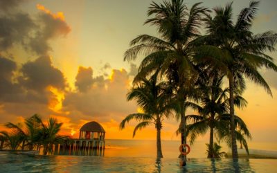
The island of Mauritius is renowned for its stunning landmarks and natural reserves that attract travelers from around the world. Visitors can explore the lush Black River Gorges National Park, which offers scenic hiking trails and a diverse array of endemic flora and fauna. The majestic Le Morne Brabant, a UNESCO World Heritage site, stands as a symbol of resilience and offers breathtaking views of the island’s southern coast. Additionally, the Chamarel Waterfall and the Seven Colored Earths in Chamarel showcase unique geological formations and vibrant landscapes. These natural attractions are complemented by numerous beaches, coral reefs, and marine parks, making Mauritius a perfect destination for nature lovers and adventurers alike. Tourists also enjoy visiting the Pamplemousses Botanical Garden, home to giant water lilies and a wide variety of exotic plants, providing a serene escape into nature’s beauty.
Transportation and Infrastructure
Transportation and infrastructure play a vital role in connecting the diverse regions of Mauritius, an island renowned for its stunning landscapes and vibrant culture. Efficient roads, ports, and airports facilitate movement and commerce, ensuring that residents and visitors can easily explore the island’s rich attractions. A well-developed infrastructure underpins the tourism industry and supports economic growth, making Mauritius a unique blend of natural beauty and modernity.
Road Network and Major Highways
The island of Mauritius features a well-developed transportation and infrastructure network, vital for connecting its diverse regions and supporting tourism and commerce. The road network is extensive, comprising primary, secondary, and tertiary roads that facilitate smooth travel across the island. Major highways such as the M1 and M2 serve as the main arteries, linking the northern and southern parts of Mauritius and connecting key urban centers like Port Louis and Curepipe. These highways are well-maintained and enable efficient movement of vehicles, goods, and tourists. In addition to the road network, Mauritius also has a network of local roads that provide access to rural areas and coastal regions, enhancing connectivity throughout the island. Overall, the infrastructure supporting transportation plays a crucial role in the economic development and accessibility of Mauritius, making it easier for visitors to explore the scenic locations marked on the island map.
Ports and Harbors
The island of Mauritius features a well-developed transportation network that includes ports and harbors crucial for trade and tourism. Its strategic location in the Indian Ocean makes it a vital hub for maritime activities, supporting the movement of goods and passengers between the island and global destinations.
- Port Louis Harbor: The main port serving as the commercial and cargo hub of Mauritius, equipped with modern facilities for shipping and logistics.
- Grand Baie Harbor: A popular destination for yacht and cruise ships, supporting tourism and recreational boating activities.
- Rodrigues Island Port: Facilitates connectivity between Mauritius main island and Rodrigues, enabling transportation of goods and residents.
- Impacts on Infrastructure: The ports are complemented by extensive road networks and airports that enhance accessibility and support economic growth.
- Future Developments: Investments are ongoing to expand port capacity and upgrade harbor facilities to meet increasing maritime trade demands.
Airports and Accessibility
The island of Mauritius boasts well-developed transportation infrastructure that enhances accessibility for residents and visitors alike. Its network of roads and highways connects major cities, towns, and tourist destinations, facilitating smooth travel across the island. The country’s airports, including Sir Seewoosagur Ramgoolam International Airport, serve as vital gateways, offering international flights from numerous destinations. Accessibility is further supported by public transportation options such as buses and private taxi services, making it easy to explore the diverse regions of Mauritius. Overall, the robust transportation and infrastructure systems contribute significantly to the island’s connectivity and tourism appeal, as depicted on the Mauritius map.
Economic Zones and Land Use
Economic zones and land use planning play a crucial role in shaping the sustainable development of regions like Mauritius. These areas are designated to promote economic growth, attract investment, and manage land resources efficiently. Understanding the layout of economic zones on the Mauritius map provides valuable insights into the island’s development strategy and land utilization patterns, ensuring balanced progress while preserving its natural beauty.
Agricultural Areas
The island of Mauritius features a diverse land use pattern, including designated economic zones, agricultural areas, and urban development. These zones are strategically planned to promote economic growth while preserving natural and agricultural landscapes.
- Economic Zones: Mauritius has established special economic zones to attract foreign investment, foster export-oriented industries, and create job opportunities. These zones are typically located near ports and major infrastructure to facilitate trade.
- Land Use Planning: The land use plan for Mauritius balances industrial development, residential areas, and environmental conservation. Large portions of the island are designated for protected areas and national parks to conserve biodiversity.
- Agricultural Areas: Agriculture remains a vital part of Mauritius’s economy, with sugarcane being the predominant crop. Other agricultural activities include tea, fruits, and vegetables, primarily in the inland and rural regions.
- Urban Areas: Major towns such as Port Louis, Curepipe, and Quatre Bornes are the centers of commerce, administration, and services, with expanding residential zones to accommodate growing populations.
Industrial Zones
Economic zones and land use policies play a crucial role in shaping the development of Mauritius, particularly its industrial zones which are strategically positioned to support the nation’s economic growth. These zones, including Export Processing Zones and Freeport zones, are designated areas that offer favorable conditions such as tax incentives and infrastructural support to attract manufacturing and export-oriented industries. Proper land use planning ensures that these industrial zones are developed sustainably, balancing economic needs with environmental preservation. The map of Mauritius highlights these zones in designated areas, showing their proximity to ports, transportation hubs, and urban centers, which enhances their effectiveness. By focusing on well-organized industrial zones, Mauritius aims to boost its industrial output, create employment opportunities, and foster sustainable economic development, all while maintaining efficient land utilization and environmental considerations.
Commercial and Residential Areas
The island of Mauritius features a diverse landscape with designated Economic Zones and distinct land use patterns that support its growing economy. These zones are strategically designated areas that foster industrial development, trade, and investment opportunities.
Within Mauritius, Commercial Areas are typically concentrated in urban centers such as Port Louis and Curepipe, where shopping districts, markets, and business hubs facilitate economic activities. These areas are designed to accommodate retail stores, offices, and service providers, contributing significantly to the island’s commercial growth.
Residential Areas on the island are spread across various towns and coastal regions, offering a mix of housing options from modern apartments to traditional homes. These areas are carefully planned to provide residential comfort while maintaining proximity to commercial and industrial zones, enhancing the quality of life for residents.
Overall, Mauritius’s land use planning integrates economic zones with residential and commercial areas to promote sustainable development, balancing industrial growth with community needs and environmental considerations across the island.

0 Comments